Journal of Samuel Kiechel
3 – 9 February 1586
From Copenhagen to Helsingborg
“The aforementioned Øresund is no more than one German mile wide, and all ships sailing into and out of the country must lower their sails, drop anchor and pay the toll. A ship loaded with grain, salt, herring or similar goods, pays half a Reichsthaler per ‘last’.“
Die Reisen des Samuel Kiechel aus drei Handschriften, K. D. Haszler (ed.), Stuttgart 1866, p. 56f; Bayerische Staatsbibliothek.
In Copenhagen
After crossing the Danish islands, Samuel Kiechel arrived in Copenhagen. Regarding his experience travelling to Scandinavia during winter so far, he observed that it was much colder in Denmark than in his hometown of Ulm, Swabia, and he explained that the farther north one travelled, the colder it became.
Kiechel’s remarks on Copenhagen are typically brief. He noted that the city, which is the capital of the Kingdom of Denmark, is quite small and lacks fortifications. The Danish king resides there, but the palace could easily be mistaken for a fortress. Additionally, Copenhagen boasts a very deep harbour that can accommodate even large, heavily laden ships. At the time, Kiechel observed that all vessels in the harbour were trapped in the ice, and eight large ships belonging to the king were anchored close together near the palace.
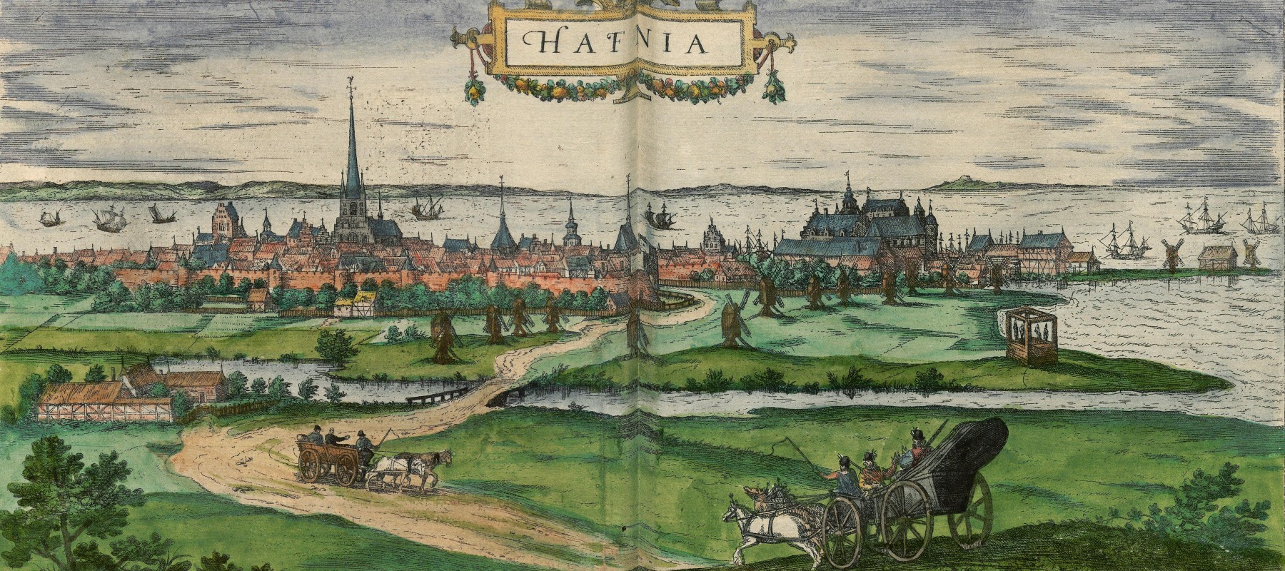
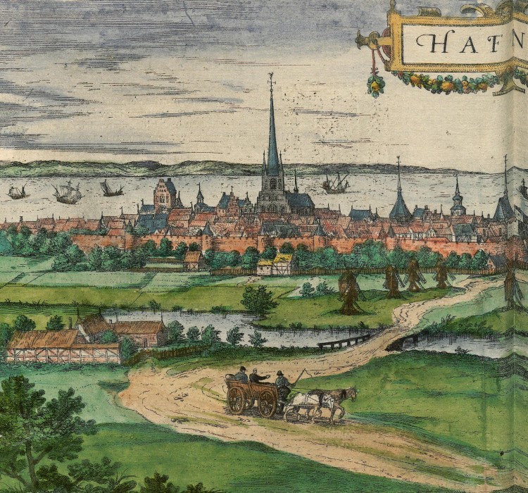
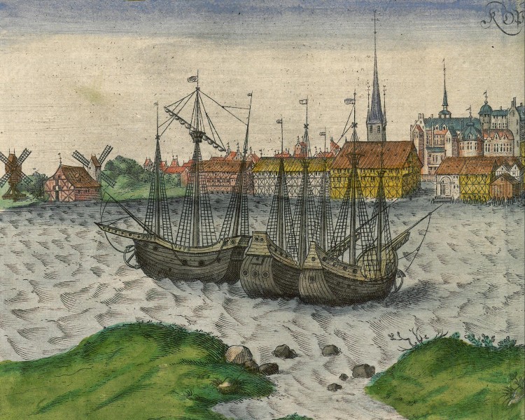
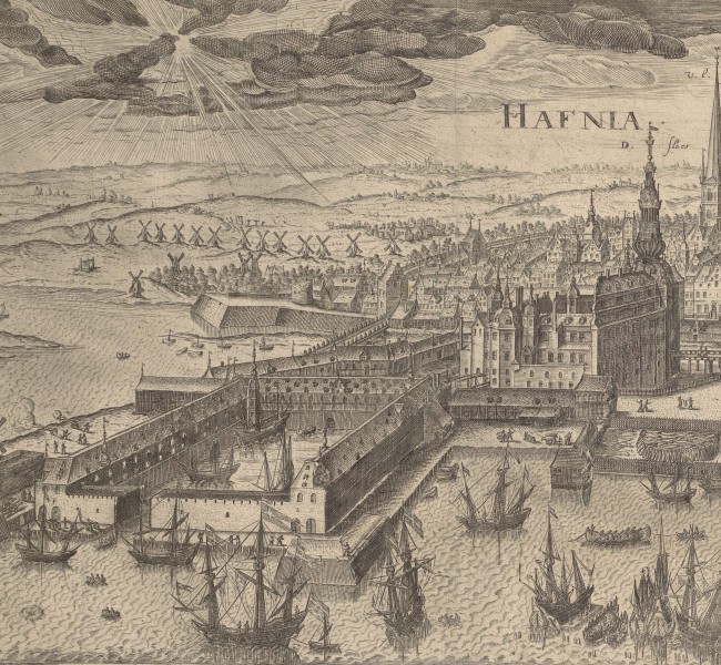
Two views of Copenhagen are featured in volume four of the Civitates Orbis Terrarum. Both are profile views and appear on the same page. The first depicts Copenhagen from the land, with a farm, a few windmills, and two carriages in the foreground: a peasant’s cart leaving the city and the coach of a wealthy individual approaching Copenhagen.
In the view, the city’s silhouette has two focal points: the Church of Our Lady and the royal palace. Kiechel mentioned that the palace looked like a fortress, and he was right. Originally built as a castle in the late Middle Ages to protect the harbour, it had, by the mid-fifteenth century, become the residence of Danish kings. At the time of Kiechel’s visit, Frederick II (1534–1588) was King of Denmark.
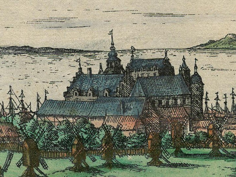
The royal palace in Copenhagen, 1588
Today, neither the Church of Our Lady nor the royal palace still exist. The church was destroyed by fire in the eighteenth century. The old palace was demolished and rebuilt several times. Today, the site is occupied by Christiansborg Palace, constructed in the early nineteenth century.
In the background of this view, behind the city’s silhouette, are the Øresund and, on the horizon, the coast of Scania. The Øresund is the easternmost of the three large straits connecting the Baltic to the North Sea. The other two are the Little and Great Belt, which our traveller had crossed in the previous days. The Øresund separates the Danish island of Zealand from the Swedish province of Scania.
While in Copenhagen, Kiechel heard that one winter had been so cold that the sea had frozen over, allowing people to travel across the ice in the Øresund to Malmö on the other side. He was astonished and wrote that it must have been very cold for the Sound to freeze over, as its waters are usually very rough.
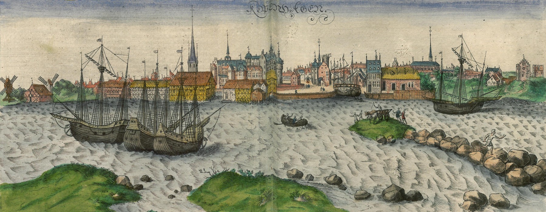
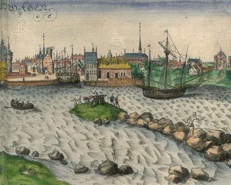
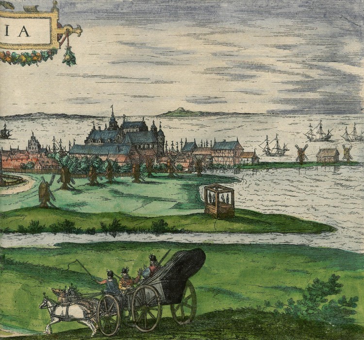
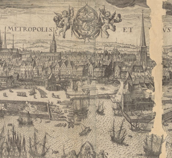
The second view in the Civitates shows Copenhagen from the Øresund and the harbour. The narrow strips of land in the foreground are islands close to the coast that offer some protection to Copenhagen’s harbour from the sea. The city appears relatively small, just as Kiechel described. But its significance as a major trade centre is highlighted by numerous large ships either anchored or at sea. The palace and the Church of Our Lady are also visible.
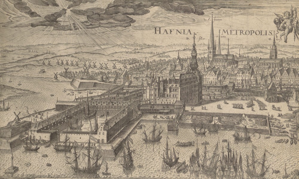
An alternative view of Copenhagen from the early seventeenth century provides a more detailed depiction of the city. In this image, the harbour is in the foreground with the Øresund on the right — both filled with many ships. On the right, beside the water, is a shipyard. Meanwhile, on the far left side of the image stands the Arsenal of Copenhagen, built in 1604. Behind and to the right of the Arsenal is the palace, with the Church of Our Lady and other smaller churches situated in the background. Additionally, compared to the images in the Civitates and Kiechel’s comments, Copenhagen is now surrounded by a wall.
Travel Plans
Samuel Kiechel spent five days in Copenhagen, staying at the house of a man named Hanns Runckh. Runckh was born in Hamburg, spoke German, and now lived in Copenhagen, providing accommodation for German travellers. Although Kiechel does not mention how he learnt about Runckh’s house, he probably just followed his companions, the two merchants from Flensburg.
Having reached the city, Samuel Kiechel had to decide how he should proceed. He could not leave the city by ship because it was winter and the sea was frozen. But he was also not in the mood to return to Germany along the same route he had arrived.
While he pondered what to do, two merchants from Lübeck arrived and took their accommodation in Hanns Runckh’s house. Both men had businesses and warehouses in Sweden and wanted to travel to Stockholm. Kiechel inquired about them and learnt that both men had good, honest reputations. So, our traveller approached the merchants and asked if he could join them on their journey. The two men agreed. In retrospect, Kiechel mentioned that they would prove their good reputation was well deserved.
To Helsingør
Samuel Kiechel and his two new companions left Copenhagen around noon on 8 February 1586, riding north along the coast of the Øresund in the back of a cart. As they travelled, the freezing weather and strong northerly wind cut into their faces. Kiechel worried he might suffer frostbite on his nose or ears, a concern fueled by stories he had heard from his innkeeper in Copenhagen. The innkeeper recounted a winter journey from Bergen, Norway, when he travelled with fourteen others—only six returned with their ears intact, while the rest suffered frostbite from the cold and wind.
The travellers arrived in Helsingør, a town in the northeast of Zealand, in the evening. Kiechel wrote that Helsingør was a small, unfortified town by the sea. The sea was called the Sound (Øresund). Next to the town was Kronborg Castle. It had been built by the current king, Frederick II (1534-1588), and was fortified with mounted guns and garrisoned by many soldiers.
The Sound Toll
The reason for a heavily armed and fortified castle at the northeastern end of Zealand was the Øresund. This waterway between the island of Zealand and the coast of Scania was the most vital shipping lane connecting the Baltic and the North Seas. It was at its narrowest at Helsingør. A toll, known as the Sound Toll, was levied on all ships passing through the Sound at Helsingør. This toll was the primary source of income for the Kingdom of Denmark for many centuries. It was introduced in the fifteenth century (1429) and abolished in 1857. Tolls were also enforced in the Great Belt and the Little Belt, which were the only alternative sea routes.
A sixteenth-century navigational chart shows the Øresund and the surrounding coastlines in detail. The chart is oriented eastward and depicts the coast of the Sound from southern Norway to the province of Scania. It contains detailed information about water depths, natural hazards, and safe anchorages.
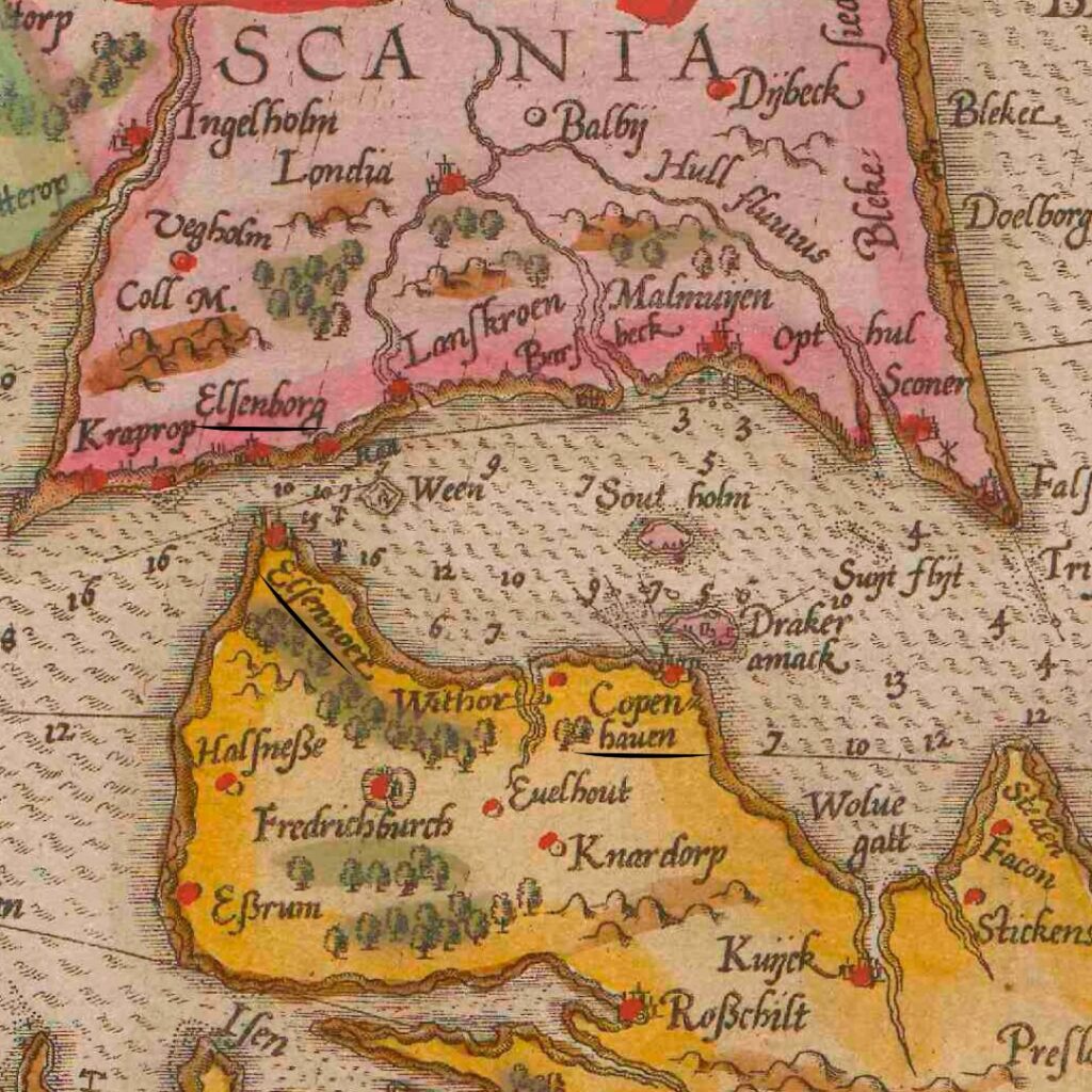
Naval chart of the Øresund (1596) with Helsingborg (Elsenborg), Helsingør (Elsennoer) and Copenhagen (Copenhauen)
Samuel Kiechel was interested in the toll and traffic on the Sound. He wrote: The Øresund is no wider than one German mile, and all ships entering and leaving Denmark must stop and pay a toll. Our traveller further explains: A vessel carrying grain, salt, herring, or similar goods must pay half a Reichsthaler per ‘Last’. Ships without cargo, only carrying ballast, still had to pay a quarter of a Reichsthaler per ‘Last’. According to our traveller, it was a hefty toll.
A Reichsthaler was a standard silver coin introduced in the Holy Roman Empire in 1566. It was accepted outside of the Empire, especially in trade between northern German cities and Scandinavia. Samuel Kiechel often used currencies he was familiar with to communicate the value of things.
A ‘Last’ was a unit of weight and volume used during the Middle Ages and early modern period to estimate the carrying capacity of ships. One ‘Last’ was approximately 2,000 kilograms in weight or about 2.7 cubic metres in volume.
Kiechel further reports: In good weather, it often happens that fifty to sixty ships or more pass through the Sound in a single day. These ships sail from Holland to Danzig (Gdańsk) to collect grain. Despite sailing empty, they must lower their sails and pay the toll. All ships heading to Sweden, Finland, Narva, Rügen (Island of Rügen), Reval (today: Tallinn), Königsberg (today: Kaliningrad), Danzig (Gdańsk), Stettin (Szczecin), Stralsund, Greifswald, Rostock, Wismar and Lübeck must pass through the Øresund. All ships sailing westward towards the Netherlands, France, England, Spain, and Portugal also need to use the Sound. For our traveller, it was clear that the toll was Denmark’s primary source of income.
Regarding control of the Sound, Samuel Kiechel noted: Directly opposite Helsingør is a village called Helsingborg with a castle on a hill above it. No ship can safely sail through the Sound as the mounted guns of the castles at Helsingør and Helsingborg can fire all the way to the opposite coast. Kiechel also learnt that ships shouldn’t travel under full sail through the Sound. During the summer, royal Danish ships are present. They are armed with guns and ammunition and carry soldiers and sailors. These ships are ready to raise anchor at any moment. Therefore, no vessel can pass through the Øresund without paying the toll.
Views of Helsingør and the Øresund
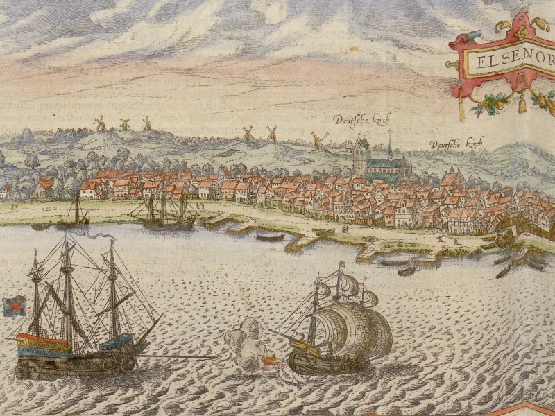
Helsingør, 1598
A view of Helsingør is in volume five of the Civitates Orbis Terrarum. The town is depicted from the east with the Øresund in the foreground. Kronborg Castle appears on the right side of the image. Helsingør is positioned to its left and shown as a small town. Two churches are highlighted by their names. They are both labelled “Deutsche Kirch” (German Church), which is likely an error on the part of the mapmakers. The largest church in Helsingør is St. Olaf’s Church. The other, smaller church, marked as “Deutsche Kirch” on the map, might have been built by German merchants who settled in the town.
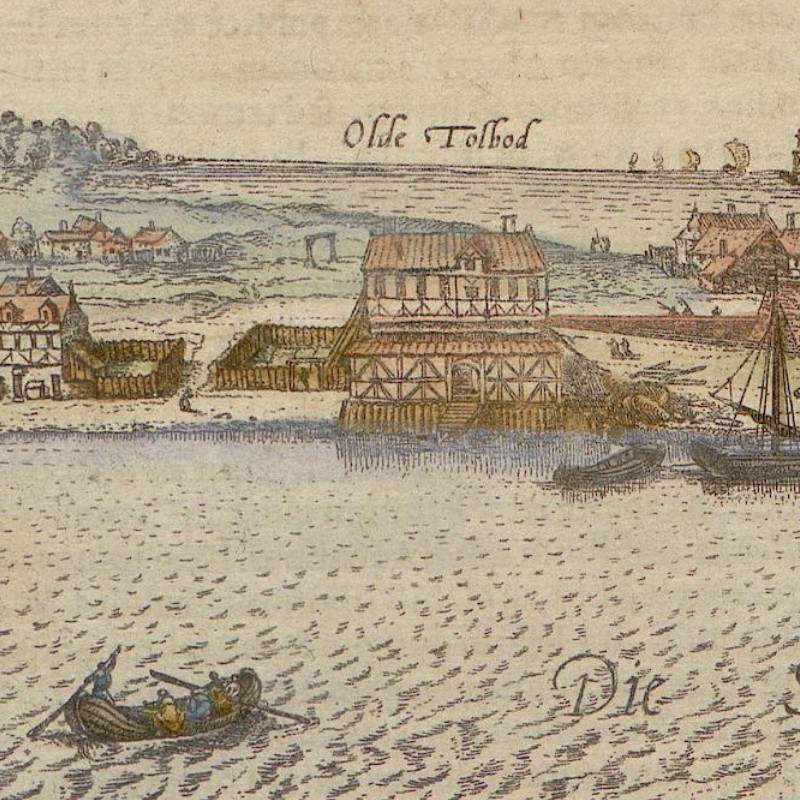
Between the town and Kronborg Castle, you can see a large house at the water’s edge named “Olde Tolbod” (Old Tollhouse). Presumably, ships had to stop there and pay the toll. Some ships are shown in the foreground, and a small rowing boat is moving towards the toll house.
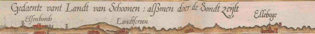
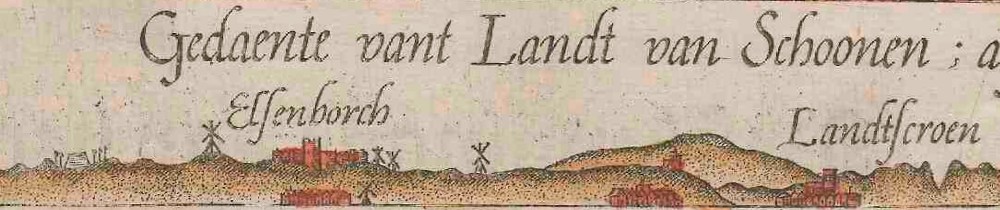
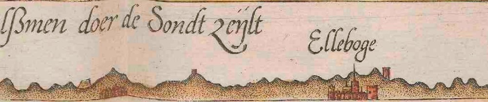
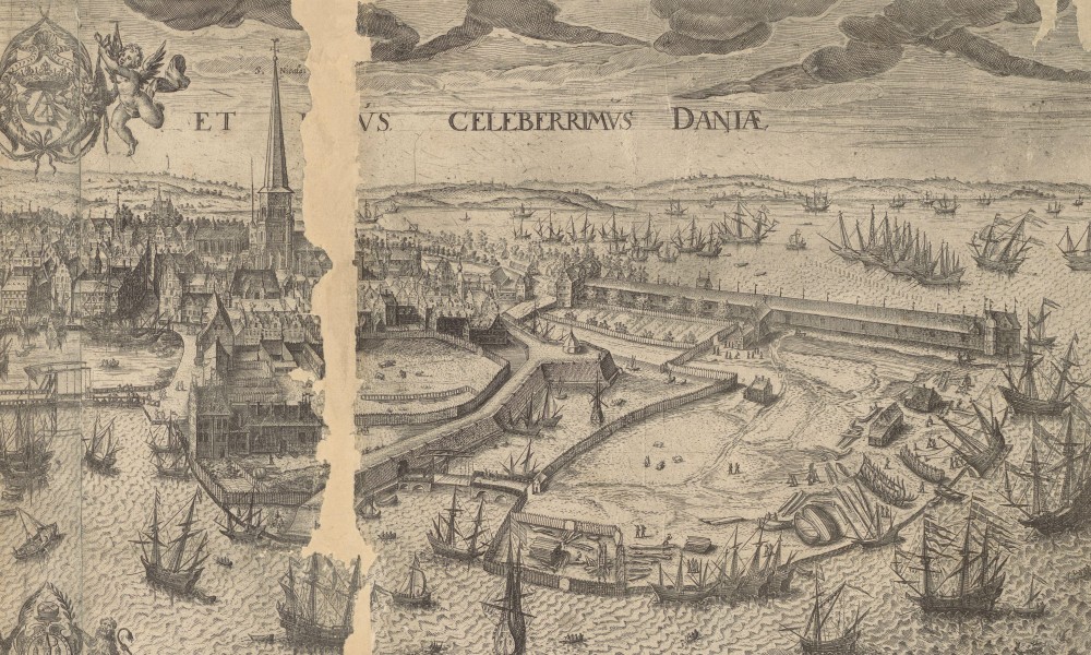
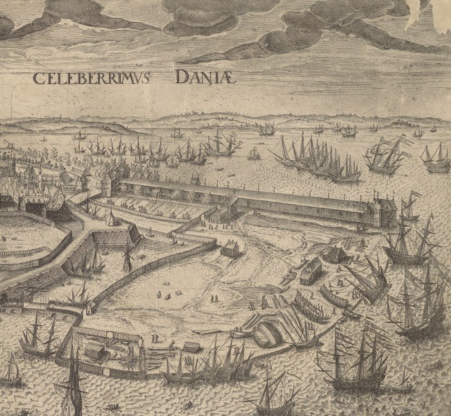
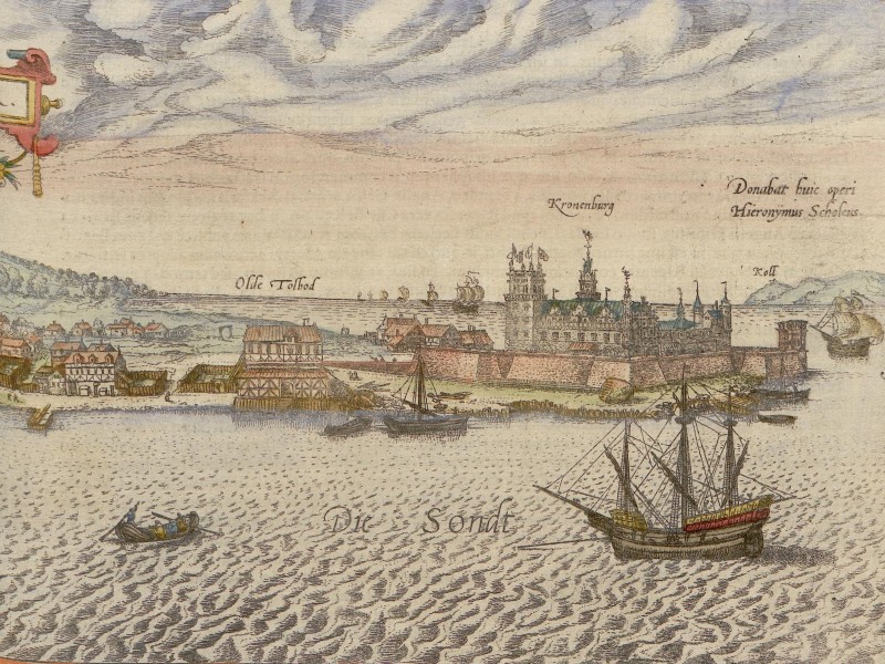
A bird’s-eye view of the entire Øresund from the west appears in volume four of the Civitates. Kronborg Castle is at the centre of the scene, highlighting its importance in regulating traffic through the Sound. In the waters surrounding Kronborg, more than forty large ships can be seen; many are anchored on both sides of the castle, likely stopping to pay the toll. Some gunfire is also seen: two ships are firing their cannons, along with a single shot from Kronborg. These shots could be gun salutes, or they might have been added to the view to demonstrate that Kronborg is not only strategically located but also heavily fortified.
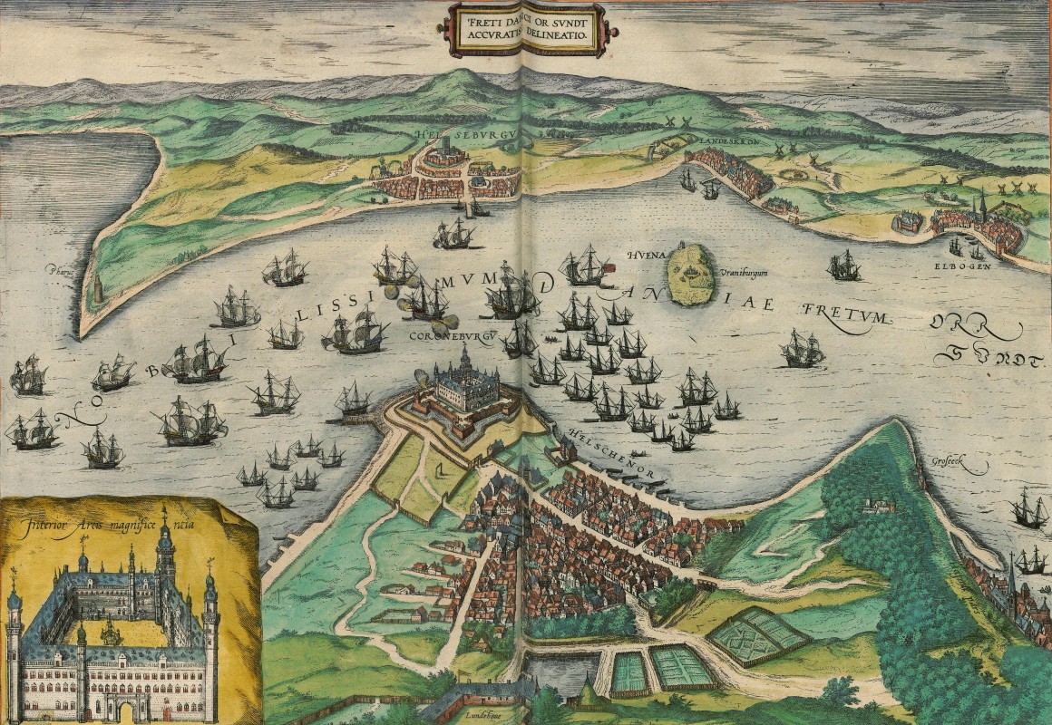
Øresund, 1588
Below Kronborg, to the right, is the town of Helsingør, and in the lower right corner of the map, a small section of Copenhagen (Hafniae pars). Across the Sound from Kronborg, the village and castle of Helsingborg are depicted. On the right side of Helsingborg (to the south), along the coast of the Sound, are the cities of Lund (Landeskron) and Malmö (Elbogen).
A depiction of Helsingborg is also included in the Civitates, but upon closer inspection, it is merely a cut-out from the Øresund view.
Crossing the Sound
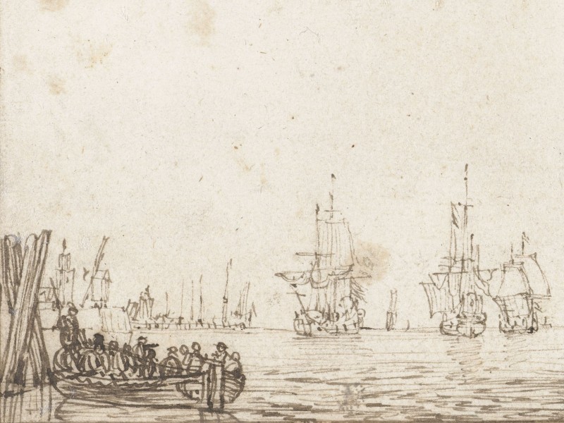
Samuel Kiechel and his companions were fortunate. The day after they arrived in Helsingør, a boat was departing for Helsingborg across the Øresund. Kiechel pointed out that during winter, travellers often waited three or four days for a vessel to Helsingborg because of the ice. He explains: The Øresund is very narrow at this point and filled with ice, but it does not freeze over completely. When the wind blows towards the sea, it pushes the ice out of the Sound, but when it blows towards the land, it pushes the ice back in. There is rarely a moment without wind, so crossing the Sound in winter is always dangerous.
The boat left Helsingør with the wind blowing towards the sea and the water mostly free of ice. But throughout the crossing, there was the fear that this might change. A shift in the wind would have brought the ice back, and the boat would then become stranded in the middle of the Sound with no way to reach either side. Fortunately, the weather remained stable, and the travellers reached Helsingborg safely.
Illustrations & References
All images are in order of appearance with links to sources on external websites:
- Copenhagen, in: Braun, Georg, Hogenberg Frans: Civitates Orbis Terrarum (4), Cologne 1594, fol. 28v; Heidelberg University.
- Waghenaer, Lucas Jansz., Teerste [-tweede] deel vande Spieghel der zeevaerdt, Leiden 1585, pt. 2, fol. 8v, map 31; Utrecht University Repository.
- van Campen, Jan Diricks, Gezicht op Kopenhagen, 1570 – 1622; Rijksmuseum Amsterdam.
- Waghenaer, Lucas Jansz., Thresoor der zeevaert, inhoudende de geheele navigatie ende schip-vaert vande Oostersche, Noordtsche, Westersche ende Middellantsche Zee, met alle zee-caerten daer toe dienende …, Amsterdam 1596, fol. 116v; Utrecht University Repository.
- de Vlieger, Simon, Stille zee met schepen en een roeiboot links, 1610 – 1653; Rijksmuseum Amsterdam.
- Helsingør, in: Braun, Georg, Hogenberg Frans: Civitates Orbis Terrarum (5), Cologne 1599, fol. 33v; Heidelberg University.
- Øresund, in: Braun, Georg, Hogenberg Frans: Civitates Orbis Terrarum (4), Cologne 1594, fol. 26v; Heidelberg University.