Samuel Kiechel left the Danube, crossed the Bohemian Forest, and was about to reach Prague, the first major stop on his journey. As our traveller approaches the city, I would like to introduce one of the primary sources that provides insight into what the sixteenth-century cities Kiechel visited looked like: the Civitates Orbis Terrarum. Most cities have changed considerably over the past four centuries. The Civitates offers a glimpse into Samuel Kiechel’s world and gives us an idea of what our traveller experienced.
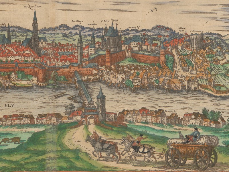
View of Görlitz in the Civitates Orbis Terrarum, 1575
The Civitates Orbis Terrarum
The sixteenth century was a period of increased interest among Europeans to learn more about distant lands. Portuguese and Spanish explorations a century earlier had provided the initial impulse to this growing curiosity; news about colonies, expeditions and the many new and exotic commodities had sustained it.
Maps, in particular, became a popular means of showcasing the expanding knowledge of the New World and depicting the Old World with greater detail and accuracy. Advances in cartography and the use of the printing press, another significant Renaissance invention, contributed to a rise in the production, publication and distribution of maps. Maps could now be reproduced and printed in large quantities and sold at a reasonable price.
A significant development in cartography was the publication of the Theatrum Orbis Terrarum in 1570 by Abraham Ortelius. It was the first modern atlas, featuring the best available maps printed in a consistent format and bound in a book with descriptions and references to the mapmakers.
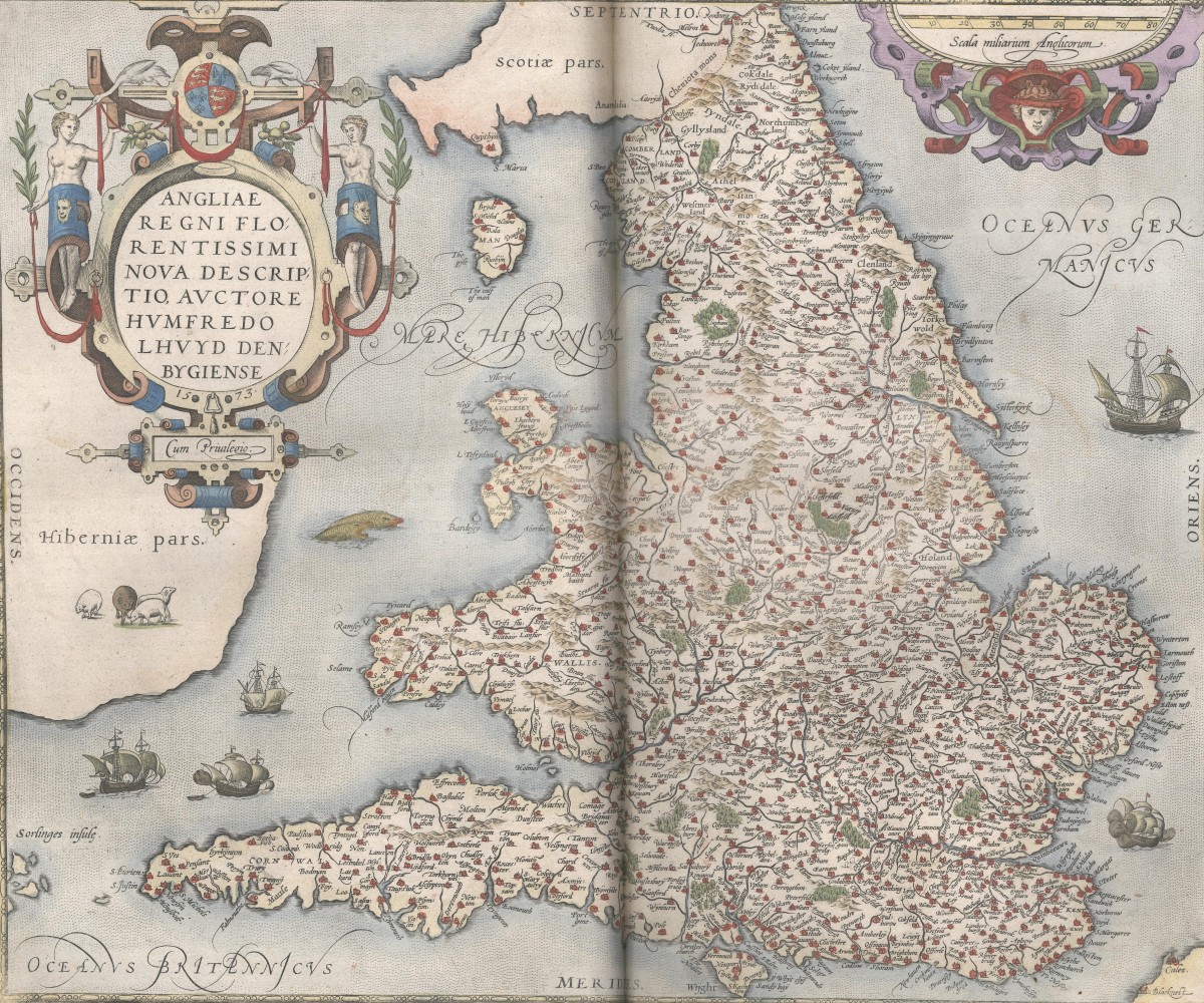
Map of England in the Theatrum Orbis Terrarum
However, people were not only interested in the new world or regional cartography but also in detailed knowledge about specific places. Cities were economic strongholds. There, increased trade across Europe and the influx of colonial goods had led to growth and prosperity. They were centres of social life, of education and the arts.
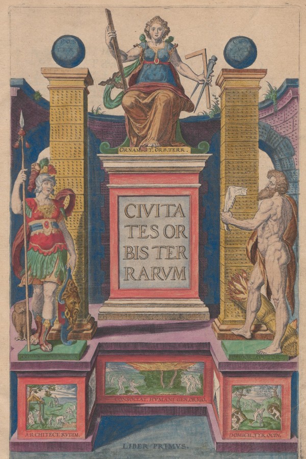
Title page of the Civitates Orbis Terrarum
Inspired by the Theatrum and initially planned as a supplement to it, Georg Braun and Frans Hogenberg published the Civitates Orbis Terrarum. Released in six volumes between 1572 and 1617, the Civitates presents views of European cities and towns, as well as places in Africa, Asia and even America. Travelling to these locations would have been time-consuming, difficult and risky. So, Braun and Hogenberg aimed to bring the cities of the world to curious, educated readers so they could learn about them without leaving home.
The first volume of the Civitates Orbis Terrarum was published in Latin in 1572, just two years after Ortelius’ work. At first, Braun and Hogenberg did not plan for more volumes. However, the book was a great success. It was translated into German (1574) and French (1575) and reissued seven times between 1575 and 1612. Due to its popularity, they decided to continue. The second volume of the Civitates was published in 1575, the third in 1581, the fourth in 1588, the fifth in 1598, and the last in 1617. The title Civitates Orbis Terrarum was originally only used for the first book. Today, the entire collection is known by this name.1
The Publishers
Georg Braun (1541-1622), a clergyman from Cologne, was the editor of the Civitates. He spent two years (1566-1568) in Antwerp as a private teacher to the son of a wealthy Cologne merchant. Antwerp was the cultural centre of the Low Countries. During his time in the city, Braun presumably got to know artists, scholars, publishers and engravers — contacts that would later prove useful when he set out to publish the Civitates.2
Georg Braun’s co-publisher, Frans Hogenberg (1535–1590), was among the leading engravers of the late sixteenth century. Originally from Flanders, Hogenberg had lived in Antwerp but was forced to emigrate to Cologne because of religious tensions arising from the Protestant Reformation. He had worked on many maps for Abraham Ortelius’ Theatrum Orbis Terrarum before he began collaborating with Georg Braun on the Civitates.
Hogenberg’s work with Ortelius probably inspired the idea of creating a city atlas. Ortelius was actively involved in bringing this idea to fruition. A letter from Georg Braun to the esteemed cartographer, requesting advice on using German place names instead of the usual Latinised versions, exemplifies their cooperation.3
For each volume of the Civitates Orbis Terrarum, Georg Braun wrote the foreword and compiled the descriptive texts accompanying each view. He had built a network of contacts to obtain drawings of cities that had not yet been published. In the foreword to every volume, Braun even asked readers to send him images and information about their hometowns. While he directed this call mostly at the educated elites in the cities, it is an early form of public engagement with a publication.
Frans Hogenberg adapted the maps and drawings supplied by artists and other sources in his workshop to fit the layout of the Civitates before engraving and printing them.
The First Modern City-Atlas
The Civitates was not the first collection of city views. However, earlier publications such as the Nuremberg Chronicle (1493) by Hartmann Schedel or Sebastian Münster’s Cosmographia (1544) focused mainly on textual descriptions and used images solely as illustrations. These authors presented many cities as generic views unrelated to reality. For example, in his book, Hartmann Schedel reused some woodcuts multiple times to represent different places, such as Naples and Perugia.4
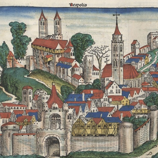
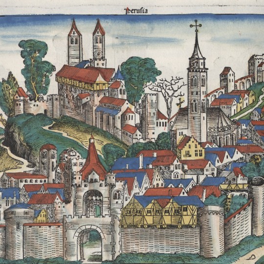
Naples and Perugia in Schedel’s Nuremberg Chronicle, 1493
Conversely, Georg Braun and Frans Hogenberg aimed to publish precise, realistic views. The six volumes of the Civitates Orbis Terrarum contain images of 475 different towns and cities. In some instances, the collection features two views of the same location, and Rome even has three. When a second view of a city appears, it is usually found in a later volume and is more up-to-date. Many city views are presented individually on separate pages, while others share a page. The extreme case is twelve Swiss cities on a double page in the first volume. Generally, however, between two and five cities share the same page.5
A short text accompanies each view of a city. The texts are usually collations of general information that Georg Braun found in popular chronicles and cosmographies, along with some contemporary news and details received by letter or oral communication from local sources. However, the maps and city views are rarely described or even mentioned in the texts. Many descriptions primarily focus on the place’s history, the etymology of its name, wealth and trade.
In contrast to the Theatrum Orbis Terrarum with its systematic structure, the Civitates appears more random. There is a rough geographical sequence in all five volumes, starting with the British Isles, Spain and Portugal, then France, the Low Countries, Germany, Scandinavia, northeastern Europe, and finally Italy and the Mediterranean. However, which cities were shown depended presumably on the images available to the publishers.
A distinctive feature of the Civitates Orbis Terrarum is the relationship between text and image. In earlier publications, such as Schedel’s Nuremberg Chronicle, the text formed a coherent narrative guiding the reader through the volume. The images were merely illustrations. In the Civitates, the views and maps take centre stage. The texts provide some additional detail, but there is no consistent narrative or order linking the cities.
Artistic Styles in the Civitates Orbis Terrarum
A notable feature of the Civitates is the variety of visual styles, as different artists contributed to the publication. Some views are top-down, showing the grid of streets in detail, similar to modern maps, while others depict cities from a bird’s-eye perspective or in profile from ground level.
The different styles are apparent in a comparison between the images of two of the artists who contributed the most views to the Civitates: Georg (Joris) Hoefnagel (1542-1600) and Jacob van Deventer (1500-1575).
Hoefnagel had travelled to Spain, Italy, France, England and Germany. During his travels, he drew and sketched numerous cities, with sixty-three of his images published in the Civitates. He commonly depicted the places from a low oblique angle, creating bird’s-eye views. Additionally, he integrated them into the surrounding countryside and often added allegorical elements or scenes of local life. However, he kept the city and its immediate surroundings separate. Hoefnagel endeavoured to depict the cities as realistically as possible, even when he embellished the images by including peripheral scenery.6
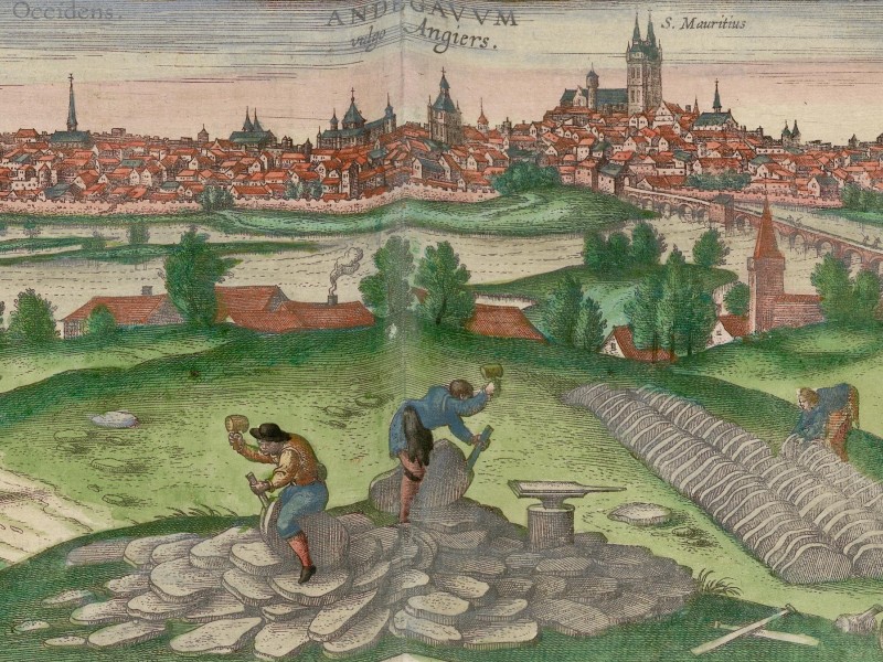
View of Angers by Georg Hoefnagel
Jacob van Deventer contributed forty-eight images to the Civitates. In the service of King Philip II of Spain, van Deventer travelled through the Low Countries, creating maps of all the towns and cities he visited. His views are top-down and resemble modern city plans. He relied on local surveys as the basis for his work. Van Deventer did not embellish his drawings. The views are remarkably accurate representations of a town’s layout. But he did not bother with the buildings. Unlike other views in the Civitates, many of his maps show only streets, canals, walls, public buildings, gates and churches, with features outside the walls such as roads, windmills, canals, rivers and surrounding minor settlements.7
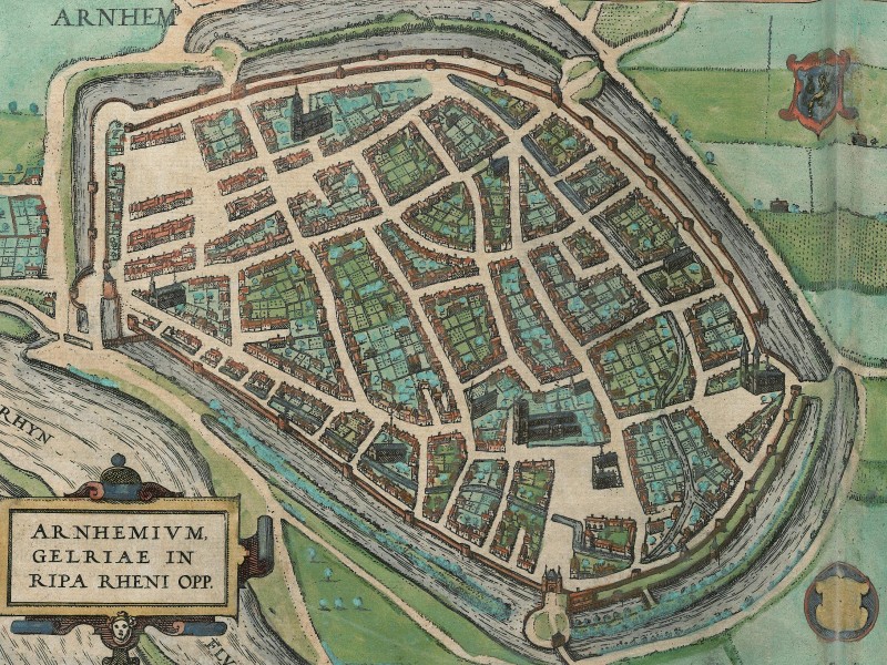
View of Arnhem by Jacob van Deventer
Van Deventer’s maps were adapted to the style of the Civitates, but you can view two notebooks with his drawings in the digital collection of the Biblioteca Nacional de España.
On Costumes and the Turks
One final, intriguing aspect of the Civitates Orbis Terrarum is the depiction of people dressed in local attire in the foreground of many views. These figures were not a product of the mapmakers’ imagination; the publishers had consulted costume books. The clothing exemplifies regional styles and fashion of the period, and even indicates how Samuel Kiechel might have been dressed.
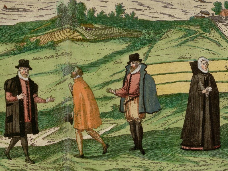
Example of people in local dress in the Civitates
Georg Braun states in his foreword to the Civitates that the inclusion of these people was a deliberate decision. The Ottoman Empire was viewed as a threat in the sixteenth century. There was a widespread fear that they might use the published maps to gather strategic information about a city’s defences. To allay this concern, Braun explains they deliberately included the people in each city-view because: “the bloodthirsty Turk, who is not allowed to see printed or painted illustrations, will never allow this book to be seen regardless of its benefits.”8 Muslims were forbidden from viewing images of humans. As a logical consequence, placing people in the foreground or around the edges of maps would prevent the Ottomans from gaining any useful information. It remains uncertain whether this precaution was adequate.
Visiting Sixteenth-Century European Cities
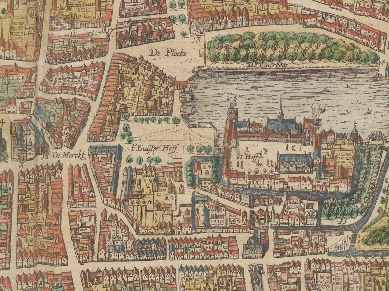
The Hague in the Civitates Orbis Terrarum
The images in the Civitates depict moats and walls, skyline-dominating churches, and gatehouses that shape the first impressions of a city to any arriving traveller. The bird’s-eye views enable us to see streets and marketplaces, as well as familiar municipal buildings like town halls, and unfamiliar structures such as armouries. Many of the prints also include a glimpse of everyday life. This could be a local scene played out in the foreground, like in Georg Hoefnagel’s images, or simply depictions of boats on a river, carts and people rushing by, or a busy harbour with cargo stacked on the quays.
Despite the desire for realism and accuracy, the city views in the Civitates are somewhat biased. Because of its popularity, publishing a city in this collection served as a form of advertising. As mentioned, Georg Braun requested contributions from the readers to showcase their city. As a result, many views focus on size, wealth and strength. The walls, churches and municipal buildings often form the central features of the images. Sometimes, these structures are depicted slightly larger than their surroundings. In many views, the publishers identified important buildings by name or function. Conversely, signs of decay, damage or low-quality housing of the poor are rarely visible.
In the 400 years since the Civitates Orbis Terrarum was first published, wars, natural disasters and modernisation have significantly altered the appearance of European cities. The Civitates, therefore, provides an invaluable window into the world of the sixteenth century. Samuel Kiechel’s journey took place at the time of its publication, and the cities featured in the collection are as close to Kiechel’s experience of those places as we can get without a time machine.
Illustrations & References
All images are in order of appearance with links to sources on external websites:
- Görlitz, in: Braun, Georg, Hogenberg, Frans: Civitates Orbis Terrarum (2), Cologne 1575, fol. 45v; Heidelberg University.
- England, in: Ortelius, Abraham, Theater of the World, Antwerp 1587, fol. 11v; Library of Congress.
- Braun, Georg, Hogenberg, Frans: Civitates Orbis Terrarum (1), Cologne 1593; Heidelberg University.
- Schedel, Hartmann, Nuremberg Chronicle, 1493, fol. 42v & 48v ; Bayerische Staatsbibliothek.
- Angers, in: Braun, Georg, Hogenberg, Frans: Civitates Orbis Terrarum (5), Cologne 1599, fol. 20v; Heidelberg University.
- Arnhem, in: Braun, Georg, Hogenberg, Frans: Civitates Orbis Terrarum (3), Cologne 1593, fol. 17v; Heidelberg University.
- Rostock, in: Braun, Georg, Hogenberg, Frans: Civitates Orbis Terrarum (5), Cologne 1599, fol. 47v; Heidelberg University.
- The Hague/Den Haag, in: Braun, Georg, Hogenberg, Frans, Civitates Orbis Terrarum (6), Cologne 1618, fol. 9v; Heidelberg University.
- Füssel, Stephan: Natura Sola Magistra — Der Wandel der Stadtikonografie in der Frühen Neuzeit, in: Braun, Georg & Hogenberg, Franz: Civitates Orbis Terrarum — Städte der Welt, Katalog der Stadtansichten (Füssel, Stephan & Althoff, Joahnnes, eds.), Cologne 2015, pp. 58-59. ↩︎
- Ibid., pp. 19-30. ↩︎
- Ibid., pp. 19-20. ↩︎
- Ibid., p. 12. ↩︎
- van der Krogt, Peter, Mapping the towns of Europe: The European towns in Braun & Hogenberg’s Town Atlas, 1572-1617, in: Belgeo 3-4, 2008. ↩︎
- Koeman, Cornelis, Schilder, van Egmond, Marco and van der Krogt, Peter, Commercial Cartography and Map Production in the Low Countries, 1500–ca. 1672, in: The History of Cartography (Woodward, David ed.), vol..3, pt. 2, pp. 1296-1383, see p. 1334. ↩︎
- Koeman, Cornelis and van Egmond, Marco, Surveying and Official Mapping in the Low Countries, 1500–ca. 1670, The History of Cartography (Woodward, David ed.), vol. 3, pt. 2, pp. 1246-1295, see p. 1275. ↩︎
- Braun, Georg, Hogenberg, Frans, Civitates Orbis Terrarum (1), Cologne 1593, Praefatio; Heidelberg University. ↩︎