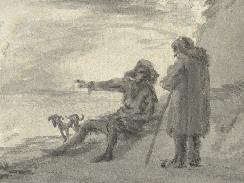
A journey was a rare and often once-in-a-lifetime experience in earlier centuries, when the idea of travelling for leisure was still unknown. As a result, for many people, their town or village and the surrounding countryside defined their horizon, a boundary rarely crossed. In such circumstances, a journey was an expedition into a world that was known and somewhat familiar in places, but also mysterious, sometimes frightening, hostile or simply unintelligible. Detailed travel guides filled with practical information to help prepare for the endeavour did not exist yet.
Itineraries and Road Maps
Samuel Kiechel was about to leave Prague and head north towards Hamburg. On his way, he will travel across the length of the Holy Roman Empire. But how did he know which road to take? Road signs were scarce or nonexistent, and public transport consisted of postal carriages along a few highly frequented routes.
Kiechel did not mention how he prepared himself for his journey. Given his background as the son of a wealthy merchant, he had received a good education and certainly had some geographical knowledge of Europe. But it isn’t easy to estimate how thoroughly he planned his adventure.
One source of helpful travel advice he might have perused was Itineraria. Itineraries were already known and in use in the Middle Ages. They were usually lists of cities, towns and villages along the route to a specific destination. Often, the lists included the distances between waypoints. Itineraries were written to guide travellers to a particular destination.
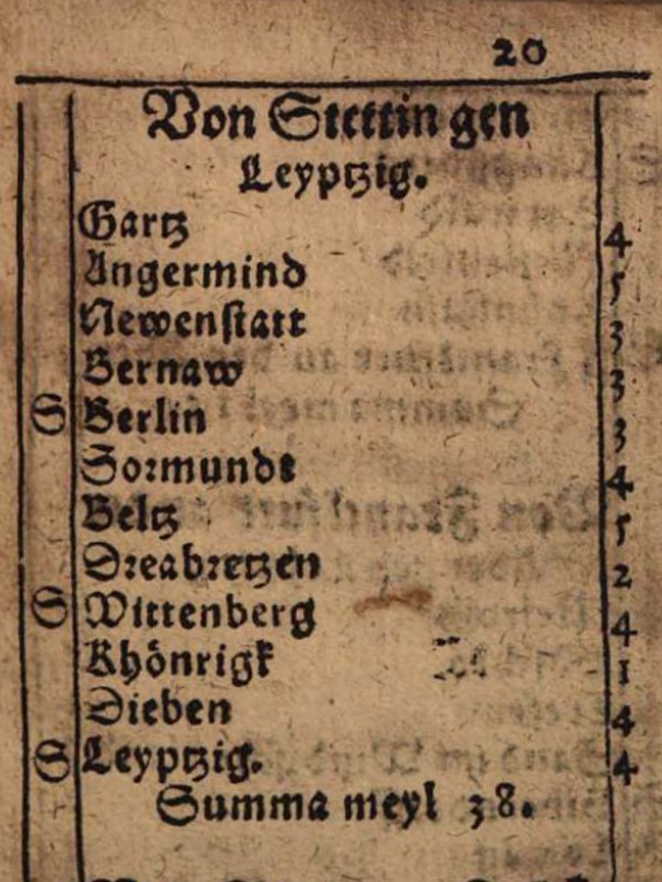
Page of an itinerary detailing a route from Stettin (Szczecin) to Leipzig, 1612
In the fifteenth century, itineraries underwent a significant evolution after the invention of the printing press. Individual itineraries were collected and published together as guidebooks to the road networks in Western and Central Europe. The roads described were the most heavily frequented routes at the time, connecting important political and commercial places. Itineraries could contain additional information, such as symbols denoting postal stations, inns and intersections with other major routes. The intersections allowed a degree of freedom while using itineraries. Travellers could change routes to reach their destinations.
It is important to note that itineraries were textual descriptions and not maps. Some early modern collections included regional maps with the places mentioned in the book highlighted. However, those maps were of limited use due to their small scale and lack of detail.
However, a notable exception to the textual form of itineraries is the Romweg-Map (Roads to Rome) by Erhard Etzlaub.
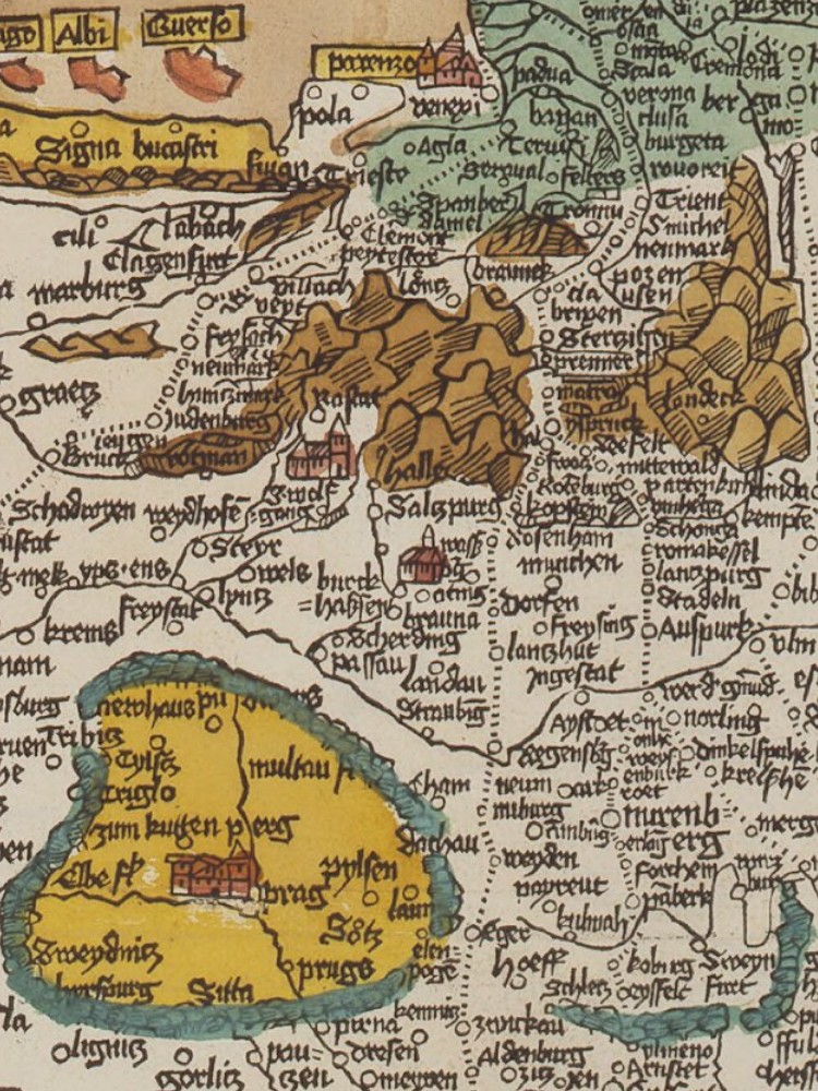
Part of the map by Erhard Etzlaub. The map is oriented southwards. Bohemia appears in the lower left corner, the Alps are in the centre, and Venice is at the top.
Etzlaub was a cartographer and physician from Nuremberg. In preparation for the many pilgrims expected to visit Rome for the Catholic jubilee year of 1500, he created a woodcut map showing the roads from the Holy Roman Empire to Rome. A text at the top of the map states: “Daß ist der Rom-Weg von meylen zu meylen mit puncten verzeychnet von eyner stat zu der andern durch deutzsche lantt” (“This is the road to Rome, from mile to mile marked with dots from one town to the next, through Germany”). Dotted lines indicate the roads to Rome, with each dot representing one mile. While road maps are common today, this map was a novelty at the time.
The Itinerary of Daniel Wintzenberger
A qualified person to write an itinerary of the major roads would, for example, be a messenger. Such a person was Daniel Wintzenberger. Wintzenberger was a messenger of the Prince-Elector of Saxony. He wrote two itineraries about the roads he knew and had travelled. The first itinerary contains routes from Dresden to various destinations across central Europe. Dresden was the residence of the Prince-Elector and the principal city of the Duchy of Saxony. The book was first published in 1578 and reprinted in 1597.1
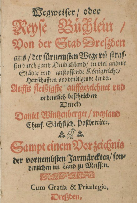
Title page of Wintzenberger’s Itinerary of Dresden, 1597
The second itinerary, published in 1595, is about routes from Leipzig.2 Both books contain similar routes because Leipzig is not far from Dresden. Presumably, this itinerary was a partial copy of the first. But it includes some additional information.
The books by Daniel Wintzenberger are an example of the kind of information a sixteenth-century traveller could obtain from itineraries. However, they are by no means comparable to modern travel guides. They contain no directions or practical advice about accommodation, food, transport or sights. Nor do they offer detailed information about the cities and towns. Itineraries were only helpful in preparing for a journey, helping travellers choose a route to a specific destination.
In his foreword, Daniel Wintzenberger clearly states his intentions and the particular audience he had in mind. The purpose of his itineraries was to guide people along the correct routes from one city to another. The audience he had in mind included merchants, fellow messengers, post riders, journeymen and travellers.
More than just Routes and Distances — the Content of Wintzenberger’s Itinerary
The itinerary of 1578 begins with a list of the larger European kingdoms, their rulers, and capitals. The subsequent section lists the Prince-electors of the Holy Roman Empire and their residences.3 These Prince-electors were the highest-ranking nobles in the Empire, responsible for electing the Emperor. This is followed by a comprehensive list of regional lords, bishoprics, and lower nobility (counts) with their extensive domains within the Empire and beyond.
Routes
The next part of Daniel Wintzenberger’s itinerary contains the actual routes. There is no recognisable system or order to the routes. Most begin in Dresden, as this was Wintzenberger’s home town.
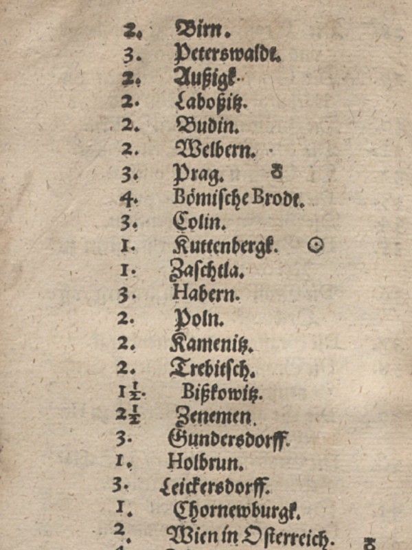
Route from Dresden to Belgrade, 1578
As an example, the first route leads from Dresden via Prague, Vienna and Budapest to Belgrade. The description lists the towns and villages along with their distances. The distances are always written first. From Dresden, it is therefore two miles to “Birn” (Pirna). From there, it is three miles to “Peterswaldt” (Petrovice), then two miles to “Außigk” (Usti nad Labem) and so on. At the end of each route, Wintzenberger wrote the sum total of the distances. In this case, the route from Dresden to Belgrade was 162 German miles (~ 1.200 kilometres4).
The first leg of this route is the same one Samuel Kiechel took, just in the opposite direction, on his way from Prague to Dresden. The locations mentioned in Kiechel’s journal are the same as in Wintzenberger’s itinerary.
Rivers
Following the routes, an extensive index lists the rivers within the Empire, along with the towns and cities on their banks. As we have seen with Kiechel’s journey along the Danube, rivers were vital for travel and trade in the Empire.
Another list details the rivers in neighbouring countries and the towns and cities along the coastlines of the North Sea and the Baltic Sea. Next, Wintzenberger noted all toll stations along the river Elbe, along with the regional lord or city to which they belonged.
Bridges
Stone bridges represented a remarkable feat of architecture in early modern Europe. Samuel Kiechel frequently mentioned them. Our traveller described the beautiful bridge over the Vltava in Prague, and he will comment on the delicate stone bridge in Dresden. Bridges were a crucial part of Europe’s infrastructure. Compared to ferries, they allowed for easy, safe crossings of large streams and often served as symbols of a city’s wealth and power.
Wintzenberger’s itinerary includes a list of eighteen major stone bridges along the routes in his book. For the Danube, Rhine and Elbe rivers, he provided separate lists with their bridges.
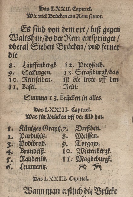
List of bridges across the Rhine and Elbe in Wintzenberger’s Itinerary, 1578
Three short paragraphs then describe the stone bridges in Dresden, Regensburg and Prague — all visited by Kiechel.
About Dresden, Wintzenberger stated that the first stone bridge was built in 1119, taking thirty years to complete. The bridge had twenty-four arches. Due to the reconstruction of the Ducal Palace, the bridge was shortened by five arches.
The Regensburg stone bridge was completed in 1146 after eleven years of construction, featuring fifteen arches. Lastly, Prague’s bridge has sixteen arches. However, Wintzenberger admitted he did not know when its construction started.
Fortifications
Furthermore, Daniel Wintzenberger listed the main fortresses in the Holy Roman Empire and neighbouring territories. He divided this list into the Emperor’s fortresses, the Prince-electors’, and various regional lords’. He also included important fortified cities within the Empire. At the end of this section, Wintzenberger pointed out key fortresses in Denmark, Sweden, Poland, Prussia, Livonia, France, England, Italy and Brabant. In total, his lists cover 189 strongholds.
The fortresses were almost always fortified cities at key points along various routes. Their locations made them strategic, economic and political centres, as well as crucial waypoints for merchants, messengers, post riders, journeymen and fellow travellers — the intended audience addressed by Wintzenberger in his foreword.
For travellers like Samuel Kiechel, large fortified cities offered not only safety but also some comfort. Kiechel passed through perilous lands on his journey, whether due to war or the region’s remoteness, where banditry could go largely unchecked. Cities provided security and amenities for travellers to recover from exhausting journeys.
The Reprinted Edition and the Leipzig-Itinerary
Daniel Wintzenberger’s first itinerary concludes at this point. But the 1597 reprint offers additional information. First, there is a compilation of the distances from Dresden to various cities. This list is somewhat curious. The majority of cities are in the Holy Roman Empire and neighbouring countries. But in between, there are Damascus (481 German miles), Jerusalem (480 German miles) and Lisbon (330 German miles).
Moreover, the reprinted edition presents an inventory of all major trade fairs held across the Empire. This list would have been helpful to merchants and travelling artisans.
Heraldry
An additional section of the itinerary consists of several pages of blank escutcheons. In heraldry, an escutcheon is the shield on which a coat of arms is displayed. Wintzenberger notes that these blank shields might be helpful for apprentices of goldsmiths, sculptors, stonemasons, carpenters and armourers. The comment is vague, and the purpose of the shields remains unclear.
The final part of the reprinted edition features several pages showing the coat of arms of the Emperor, the Prince-electors, nobility, foreign realms and various cities. These visual representations could assist travellers. Heraldic symbols were often displayed on city gates.
The Length of a Mile
Daniel Wintzenberger’s itinerary of Leipzig is mostly a copy of the Dresden itinerary. However, one notable addition is an explanation of the distances. All distances in the itinerary are in miles. But in the early modern period, the length of a mile could differ between countries.
Wintzenberger explains that the German, Spanish, Danish, Swedish, Polish, Bohemian and Livonian miles are roughly similar in length. The Norwegian, Hungarian and Swiss miles are about one and a half times as long as the German mile. One German mile equals five Italian or two French miles. Five English miles are equivalent to three German miles. Five Russian versts equal one German mile.
The Itinerary — an Early Modern Travel Guide?
Itineraries helped to plan a journey. A traveller could choose a route to a destination, learn the waypoints and distances, estimate the time needed to reach the destination and organise finances and provisions accordingly.
Samuel Kiechel did not mention the use of itineraries, but he might have consulted them in preparation. Our traveller recorded the distance he travelled each day and noted the territories he passed through. Itineraries could have provided such information.
However, while valuable, many itineraries covered only the major routes and cities. The density of the road network and the available knowledge about it varied between different parts of Europe. In northern Italy, a popular travel destination, as well as in the German-speaking countries and France, itineraries linked all major cities. The more comprehensive itineraries often included additional directions into the neighbouring and, at the time, peripheral regions of Eastern Europe and Scandinavia. Outside Western and Central Europe, itineraries were not in use.
Additionally, itineraries list the names of places and the distances between them, but do not provide directions. With the lack of road signs in the sixteenth century, a traveller could not quickly identify which ruddy track was the road to his destination. Local guidance or knowledgeable companions were still necessary.
Kiechel’s journey was not straightforward. He had most likely only a few popular destinations in mind that he intended to visit. Otherwise, our traveller’s route meandered through Europe, also taking him to peripheral regions such as Sweden, Poland, Lithuania and Livonia. While he used major roads described in the itineraries, he would switch between them or go ‘off the beaten track’.
Illustrations & References
All images are in order of appearance with links to sources on external websites:
- Schellinks, Willem, Italiaans landschap, 1637 – 1678; Rijksmuseum Amsterdam.
- Itinerary of the route from Stettin (Szczecin) to Leipzig, in: Mayr, Georg, Wegbüchlin, Augsburg, 1612, fol. 20r; Bayerische Staatsbibliothek.
- Etzlaub, Erhard, Das ist der Rom-Weg von meylen zu meylen …, ca. 1500; Bayerische Staatsbibliothek.
- Wintzenberger, Daniel, Wegweiser oder Reyse Büchlein von der Stad Dreszden, 1597; Martin-Luther-University Halle Wittenberg.
- Itinerary of the route from Dresden to Belgrade, in: Wintzenberger, Daniel, Ein naw Reyse Büchlein von der Stad Dreßden, 1578; Bayerische Staatsbibliothek.
- Bridges across the Rhine and Elbe, in: Wintzenberger, Daniel, Ein naw Reyse Büchlein von der Stad Dreßden, 1578; Bayerische Staatsbibliothek.
- Wintzenberger, Daniel, Wegweiser oder Reyse Büchlein von der Stad Dreszden, 1597; Martin-Luther-University Halle Wittenberg.
- Wintzenberger, Daniel: Ein naw Reyse Büchlein von der Stad Dreßden aus durch gantz Deudschlandt in die andern anstossenden Königreichen und umbligenden Lendern, Dresden 1578. Wintzenberger, Daniel: Wegweiser oder Reyse Büchlein von der Stad Dreszden, Dresden 1597. ↩︎
- Wintzenberger, Daniel: Ein Naw Reyse Büchlein von der Weitberümbten Churfürstlichen Sechsischen Handelstad Leiptzig, Dresden 1595. ↩︎
- The Empire was an elective monarchy and the privilege to elect a future King and Emperor was held solely by seven Prince-electors: the Archbishops of Cologne, Mainz and Trier, the Duke of Saxony, the Margrave of Brandenburg, the King of Bohemia and the Count Palatine. ↩︎
- One German mile is about 7400 metres or 7.4 kilometres. ↩︎