Journal of Samuel Kiechel
12 September – 13 November 1585
In London
“London is the main and capital city of England, a royal, beautiful, large, sprawling and wide city, but nothing is fortified, and it has no walls; people can enter and leave the city by day and night.“
Die Reisen des Samuel Kiechel aus drei Handschriften, K. D. Haszler (ed.), Stuttgart 1866, p. 22; Bayerische Staatsbibliothek.
First Impressions
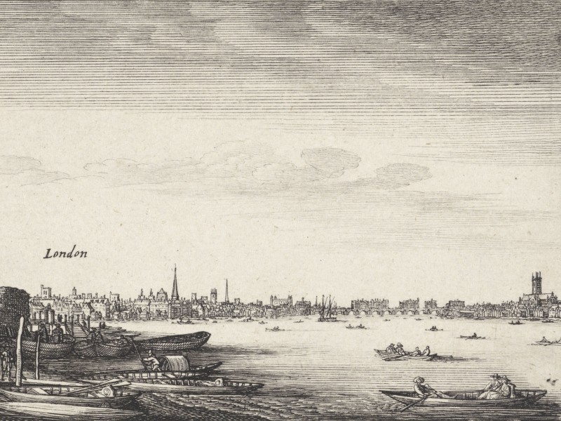
London and the Thames from the west
Samuel Kiechel arrived in London late at night, having traveled by boat up the Thames from Gravesend. With little knowledge of the city or where to find accommodation, he stumbled upon a bakery where the owner was still working. Kiechel, who did not speak English, was fortunate that the baker spoke French and allowed him to stay there for the rest of the night. The next morning, our traveller left with directions to the White Bear Inn. He knew that the inn belonged to a Dutchman and that German travellers often stayed there.
Kiechel’s first impression of London was that of a royal, beautiful, and vast city. He remarked that it is unfortified, allowing everyone to enter day or night. This must have been a new experience for a traveller from the continent, where towns and cities were surrounded by walls and had curfews. Kiechel noticed a castle (the Tower) built near the river. He also mentioned that much linen and cloth are traded in the city. These textiles are produced from the wool of the many sheep in England.
The oldest map of London is the Woodcut Map (also known as the Agas Map), dating from around 1561. It is a large, highly detailed bird’s-eye view of the city and its surrounding areas. The Woodcut Map has only survived in fragments and copies from the seventeenth century. Fortunately, using these sources and others, a project by the University of Victoria has recreated Elizabethan London as an interactive map (Map of Early Modern London (MoEML)).
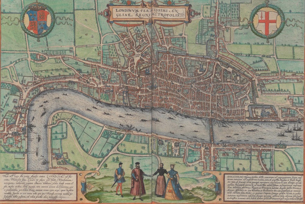
London in the Civitates Orbis Terrarum, 1572
A bird’s-eye view of London also appears as the very first image in the initial volume of the Civitates Orbis Terrarum, showing the city from the south across the River Thames. London is depicted as a large city mainly situated on the northern bank of the river, surrounded by fields and farmland. To the left is Westminster, with the Palace and Abbey. The Tower is located on the eastern edge of the city. Numerous boats are visible on the Thames, with a few larger ships on the right side of the map, in the direction where the Thames flows into the North Sea. Only a single bridge crosses the river. Various landmarks and notable buildings are labelled.
I also wish to highlight a highly detailed and quite lifelike panoramic view of mid-sixteenth-century London. Since it is not in the public domain, I cannot display it here, but it is available in the digital collection of the Ashmolean Museum in Oxford. The view was created by the Flemish artist Anton van den Wijngaerde, comprising fourteen sheets and drawn in perspective. It depicts London from the south, across the River Thames. The Palace of Westminster and Westminster Abbey are visible on the left, while St. Paul’s Cathedral and London Bridge are prominent in the centre, with the Tower discernible to the right. As always, van den Wijngaerde’s drawing offers a realistic impression of the city, reflecting what travellers like Kiechel might have seen and experienced.
A detailed written description of Elizabethan London was published by the historian John Stow in 1598, with a second edition released in 1603. His Survey of London divides the city into twenty-six wards, and Stow guides the reader through them as if on a walking tour. While Stow’s main interest was the history of the places, buildings and the origins of their names, the survey remains an exceptional source for conveying an impression of England’s capital in the late sixteenth century.
Samuel Kiechel noted that London was unfortified. However, some fortifications, such as walls and a moat, are visible on all maps and views of London. Kiechel may not have noticed them because the walls no longer marked the city’s borders. London had expanded significantly. From a population of around 70,000 people when Elizabeth I ascended to the throne in 1558, it grew to about 220,000 by her death in 1603. London was by far the largest city in England.1 Due to population growth, people started building houses outside the walls, and soon the old fortifications were overwhelmed as the city spread into the surrounding countryside. John Stow laments in his survey of London that the ditch (moat) and walls had disappeared beneath gardens and houses.2


East to west through London: Ludgate (A), St Paul’s Gate (B), Cheapside (C), Poultry (D), Cornhill Street (E), Leadenhall Street (F), Aldgate Street (G) and Aldgate (H)
According to Stow’s survey, a long thoroughfare runs from east to west through London. It begins at Ludgate in the west, then St Paul’s Gate, and follows Cheapside Street, Poultry, Cornhill Street, Leadenhall Street and Aldgate Street to Aldgate in the east. There is no obvious north-south dividing line. However, Stow notes that the narrow river Walbrook once separated London into eastern and western parts. By the late sixteenth century, this brook had been built over.3
The River Thames played a central role in London’s daily life. In the view, many ships and boats are seen travelling up and down the river. The Thames was the city’s main artery, with around two thousand small boats (wherries) transporting passengers across, along, or up and down the river. River transport was a quicker, more comfortable way to get around London than the crowded, narrow streets. Additionally, larger boats and barges of different sizes carried groups of passengers or cargo along the river.4
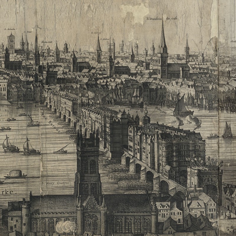
London Bridge, 1616
The only bridge across the Thames was London Bridge, which must have been quite a sight to see. John Stow writes: “It is a work very rare, having with the draw-bridge twenty arches made of squared stone, of height sixty feet, and in breadth thirty feet, distant one from another twenty feet, compact and joined together with vaults and cellars; upon both sides be houses built, so that it seemeth rather a continual street than a bridge”.5
Another intriguing source that offers a glimpse into Elizabethan London is Hugh Alley’s A caveatt for the citty of London of 1598. It is a small booklet presented to the Lord Mayor with suggestions for altering market regulation and enforcing those rules. However, a large part of the booklet features drawn views of London’s marketplaces.
Hugh Alley was not an artist, and his drawings do not match the quality of the other city views shown here so far. His depictions are fairly straightforward, and the houses around the marketplaces often look quite simple and uniform. But his focus was on the markets, the products sold, and the activity around them. As a sidenote, Alley’s images show London’s markets as he may have imagined them after his reforms were carried out (which never happened). We see none of the frantic chaos and bustle typical of busy markets in a large city.6 Nonetheless, considering the scarcity of visual sources from the late sixteenth century, Hugh Alley’s depictions still offer some insight into the inner city and the places our traveller might have visited.
Using the Woodcut Map and Hugh Alley’s drawings, I have attempted to reconstruct Samuel Kiechel’s route from the port at Billingsgate to the White Bear Inn, enabling us to walk through the centre of London. For this reconstruction, I assumed that since Kiechel was unfamiliar with the city, he would have taken the main streets.
Walking Through Elizabethan London
After spending the night in the bakery, Kiechel left for the White Bear Inn. The inn was situated on Basinghall Street in the Basinghall Ward (now called Bassishaw Ward), one of the smallest wards in London. To reach it, our traveller had to cross the city’s centre.

Samuel Kiechel’s route through London
Samuel Kiechel’s boat from Gravesend had brought him to the port of London. The port was situated between London Bridge and the Tower, in the Billingsgate and Tower Street Wards. It featured about twenty quays. Merchant ships, along with boats and barges, sailed up the Thames to moor there for loading or unloading. The vessels brought “fish, both fresh and salt, shell-fishes, salt, oranges, onions, and other fruits and roots, wheat, rye, and grain of divers sorts”.7
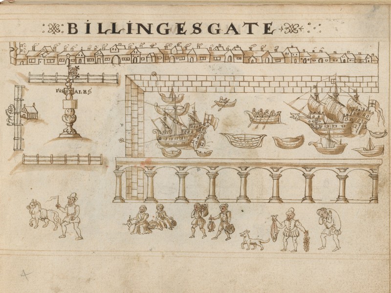
Billingsgate and the Port of London, 1598
Thames Street ran past the port and parallel to the river. The Survey of London states that Thames Street was the longest street in the city, lined with numerous large merchants’ warehouses and the Customs House.
The baker who provided shelter to our traveller for the remainder of the night was most likely located on Thames Street. John Stow mentions that cooks and pastry bakers have their shops along this street.8 One bakery in Billingsgate Ward, which would gain unfortunate fame in 1666, was the Bakery of Thomas Farriner, where the Great Fire of London supposedly began. The bakery was situated on Pudding Lane (offal was referred to as pudding, and butchers used the lane to transport said offal to the river for disposal by boats).9

From east to west: the Port in Billingsgate Ward, Thames Street, Pudding Lane, the Church of St. Magnus and New Fish Street (Map of Early Modern London)
Samuel would have followed Thames Street and then turned into New Fish Street at the crossroads where St. Magnus’ Church stood. While Thames Street ran parallel to the river, New Fish Street began at London Bridge to the south and extended northward into the city. Being directly connected to the only bridge across the Thames, it was a major route into the heart of London. According to Stow, fishmongers’ houses and various taverns lined the street.10
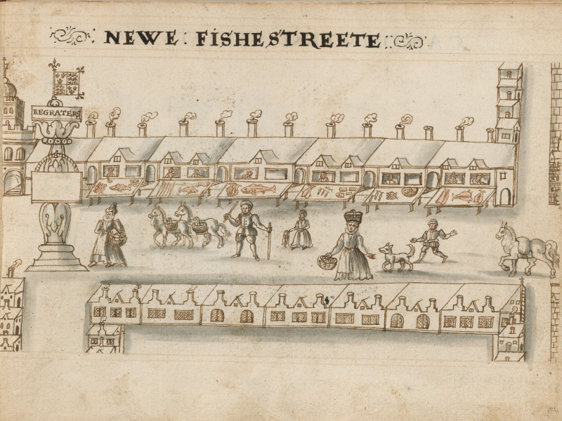
New Fish Street and the fish market, 1598
Across London, there were various food markets, each specialising in specific products such as fish, beef, white meat (poultry and dairy), fruit and vegetables. Usually, there was at least one of each type of market in both the eastern and western parts of the city.11 New Fish Street was the fish market in eastern London. Our traveller followed it to where it crossed Eastcheap Street. This was the meat market where many butchers lived.12

Eastcheap market, 1598
After crossing Eastcheap, New Fish Street became Gracechurch Street. Kiechel would have continued along it until he reached St. Benet Gracechurch on the right side. There, he would have turned left onto Lombard Street, named after the Italian merchants and bankers who were allowed to settle there in the late Middle Ages. The street remained a centre of commercial activity in the sixteenth century with the Royal Exchange and Leadenhall Market on Cornhill Street only a short distance away.

Gracechurch Street, St. Benet Gracechurch and Lombard Street (Map of Early Modern London)
Samuel Kiechel visited the Royal Exchange during his two months in London. After the visit, he wrote: The merchants of London meet daily in a beautiful building called “Börse” (Royal Exchange). It is a square building with a broad and open yard in the middle. Arcades on all four sides surround the yard, allowing people to walk under them during rainy weather and stay dry. At the Royal Exchange, all sorts of goods are sold. Whatever someone needs, it is available there. The merchants of the Royal Exchange have a tradition: they return home for lunch at one o’clock every day, despite some having to walk for half an hour. The same tradition can also be observed in Antwerp and other places in the Netherlands. Before the merchants leave their homes in the morning, they have breakfast.13
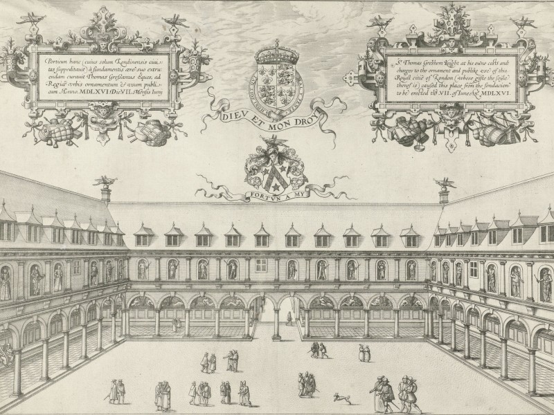
Royal Exchange, 1569
The Royal Exchange was founded in 1565 by Thomas Gresham. The building was modelled on the Antwerp Exchange.

The crossroad of Cornhill, Poultry and Lombard Street, with the Royal Exchange on the right, St. Mary Woolchurch in the centre and the Stocks Market on the left (Map of Early Modern London)
Following Lombard Street, our traveller reached a major crossroads in London. The east-west route, with Cornhill Street to the east and Poultry to the west, intersected with Threadneedle Street from the north and Lombard Street from the south. To his left, Kiechel would have seen St. Mary Woolchurch, and as he walked past it into Poultry, he would pass the Stocks Market, where stalls sold meat and fish. As the name suggests, poultry was sold in the street.
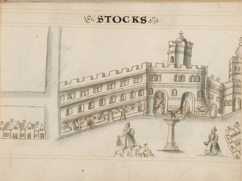
The Stocks, 1598
Soon, Poultry led into Cheapside. According to John Stow, Cheapside got its name from a market called West Cheping. It was the main market and the widest street in London, as well as the most prosperous, lined with shops and houses belonging to merchants and goldsmiths on both sides. Most of those houses stood three or four storeys high.14
In early modern London, most streets were narrow, and the upper floors of houses on both sides were built forward, projecting into the street and blocking the light. This made the streets not only narrow but also dimly lit. Imagine walking down one of these streets and entering Cheapside. About 350 metres long and between fifteen and eighteen metres wide, it was a striking contrast to find such a wide, open space within the city. As a result, Cheapside hosted notable public events, announcements and punishments.15 One such event, the Lord Mayor’s Show, Samuel Kiechel witnessed.


Cheapside with the Little Conduit in the west, Cheapside Cross, the Standard in the centre, and the Great Conduit and Mercer’s Hall at the eastern end (Map of Early Modern London)
At the eastern end of Cheapside, where Kiechel entered, stood the Great Conduit in the middle of the street and the Mercers’ Hall on his right. The Great Conduit was a fountain connected to underground channels and pipes that supplied the city with drinking water. It had been built in the mid-thirteenth century, with the underground channels later extended into other parts of the city.16
The Mercers’ Hall stood just north of the Great Conduit, and Samuel Kiechel would have passed it. Mercers were merchants, and the Worshipful Company of Mercers was one of London’s livery companies. Livery companies were trade associations or guilds created to regulate their trades. They were very protective of their trades, allowing only their members to operate within their crafts. This protectionism helped maintain the quality of their products and the training of their craftsmen. The Mercers were the oldest and most prestigious among the livery companies.
Another fountain, the Standard, stood further west on Cheapside. To the west of the Standard stood Cheapside Cross, a Catholic monument erected by Edward I in the thirteenth century in memory of his wife. By the time of Kiechel’s visit, the Cross had become a contentious object among the Protestant citizens. It will be demolished in 1643. Hugh Alley’s drawing of Cheapside depicts what are presumably the Standard and the Cross.
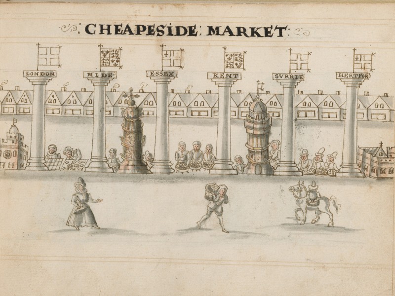
Cheapside with Cheapside Cross and the Standard, 1598. The pillars with the county names are fictional.
Both sides of Cheapside were lined with tall houses with shops on their ground floors, while the food market occupied the middle of the street. Along the southern side of Cheapside, between Bread Street and Friday Street, was Goldsmith’s Row. On the eastern end of Cheapside were the shops of the textile merchants. Leather goods were sold at Cow Face, where Milk Street and Laurence Lane branch off. With shops for luxury goods on both sides, Cheapside was the wealthiest part of London. Aside from the rich merchandise in the shops and the constant chaos and bustle of the market, the street must also have been a spectacular sight, thanks to the many colourful signs identifying the houses and shops.17

Cheapside with the Mercer’s Hall and the Conduit at the bottom, the Guildhall in the centre and White Bear Inn at the top (Map of Early Modern London)
At the western end of Cheapside stood the Little Conduit, another fountain, and the gate to St. Paul’s Churchyard. However, Samuel Kiechel would have turned right into Ironmonger Lane behind the Mercers’ Hall. As the name suggests, metalworkers had their houses and shops in Ironmonger Lane.18 Walking down this street, our traveller soon found himself in front of the Guildhall, London’s town hall and the administrative centre of the city. To the right of the Guildhall was Basinghall Street, lined with merchants’ houses. Between the Halls of the Girdlers and the Weavers, two of London’s livery companies, and opposite the church of St. Michael Bassishaw, stood the White Bear Inn.
As in our time, foreign travellers often gravitated towards inns and hostels well known for accommodating visitors from other countries. Language barriers did not exist in those establishments; information and advice about the city could be shared, and sometimes guided tours to notable attractions were arranged. These inns provided travellers with opportunities to find companions to spend time with or travel alongside. Like modern tourists, early modern travellers sought the company of fellow countrymen. For visitors from Germany, the White Bear Inn in London was one such place.
Near the Guildhall and Cheapside, the inn was located in a wealthy part of the city. According to Kiechel, its guests were mainly German travellers from noble families or, like our traveller, successful merchant families. At the inn, Kiechel met companions to pass the time in London and explore the city’s sights.
Illustrations & References
All images are in order of appearance with links to sources on external websites:
- Smith, William, London, 1588; British Library.
- Hollar, Wenceslaus, Londen gezien over de Theems vanuit Milford Stairs, 1643 – 1644; Rijksmuseum Amsterdam.
- London, in: Braun, Georg, Hogenberg, Frans, Civitates Orbis Terrarum (1), Cologne 1593, fol. A; Heidelberg University.
- Visscher, Claes, Londinum florentissima Britanniae urbs, 1616; Folger Shakespeare Library, Washington DC.
- Billingsgate, in: Alley, Hugh, A caveatt for the citty of London, or, A forewarninge of offences against penall lawes [manuscript], 1598, fol. 9r; Folger Shakespeare Library, Washington DC.
- The Route of Samuel Kiechel reconstructed on: Jenstad, Janelle, Newton, Greg, McLean-Fiander, Kim (eds.), The Agas Map of Early Modern London, 2013-present; University of Victoria, Victoria, BC.
- New Fish Street, in: Alley, Hugh, A caveatt for the citty of London, or, A forewarninge of offences against penall lawes [manuscript], 1598, fol. 10r; Folger Shakespeare Library, Washington DC.
- Eastcheap, in: Alley, Hugh, A caveatt for the citty of London, or, A forewarninge of offences against penall lawes [manuscript], 1598, fol. 11r; Folger Shakespeare Library, Washington DC.
- Hogenberg, Frans, Beurs in Londen, 1569; Rijksmuseum Amsterdam.
- Stocks, in: Alley, Hugh, A caveatt for the citty of London, or, A forewarninge of offences against penall lawes [manuscript], 1598, fol. 14r; Folger Shakespeare Library, Washington DC.
- Cheapside, in: Alley, Hugh, A caveatt for the citty of London, or, A forewarninge of offences against penall lawes [manuscript], 1598, fol. 15r; Folger Shakespeare Library, Washington DC.
- Mortimer, Ian, The Time Traveller’s Guide to Elizabethan England, London 2021, p. 15. ↩︎
- Ibid., pp. 19f. ↩︎
- Stow, John, Survey of London, 1598, pp. 107f. ↩︎
- Ibid., p. 13. ↩︎
- Ibid.; pp. 25f. ↩︎
- Harding, Vanessa, Cheapside: commerce and commemoration, Huntington Library Quarterly 71/1, 2008, pp. 77-96. ↩︎
- Stow, Survey, p. 185. ↩︎
- Ibid., p. 124. ↩︎
- Ibid, p. 189 ↩︎
- Ibid., pp. 190-194. ↩︎
- Harding, Cheapside. ↩︎
- Stow, Survey, pp. 190-194. ↩︎
- Die Reisen des Samuel Kiechel aus drei Handschriften, K. D. Haszler (ed.), Stuttgart 1866, p. 29; Bayerische Staatsbibliothek. ↩︎
- Ibid., pp. 240f, Mortimer, Guide to Elizabethan England, p. 34. ↩︎
- Harding, Cheapside. ↩︎
- Stow, Survey, p. 237. ↩︎
- Harding, Cheapside. ↩︎
- Ibid., p. 242. ↩︎