Journal of Samuel Kiechel
6 – 21 June 1586
From Danzig to Königsberg
“In the area, for some miles along the Baltic coast, amber is found; the sea washes it onto the shore. All amber belongs to the margrave, who makes a large profit from exporting it, especially to Turkey. It is prohibited, under threat of corporal punishment, for anyone except those tasked with it to pick up or collect amber.“
Die Reisen des Samuel Kiechel aus drei Handschriften, K. D. Haszler (ed.), Stuttgart 1866, p. 98; Bayerische Staatsbibliothek.
To Elbing (Elbląg)
Samuel Kiechel stayed in Danzig (Gdańsk) for about two weeks and left the city on 6 June in a carriage with two Englishmen. They crossed the Vistula three miles outside the city. As they were close to their destination, the city of Elbing (Elbląg), the carriage ran off the road and crashed.
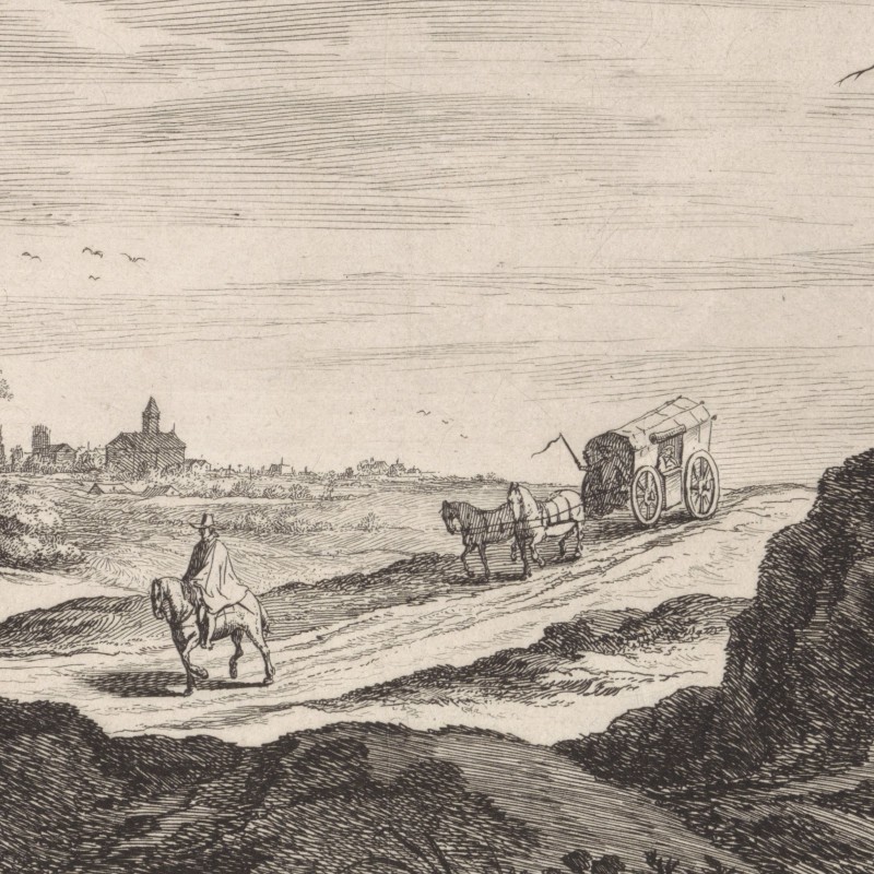
Kiechel wrote that this happened because they were travelling at high speed. He added pointedly that, given the time spent getting the carriage back on the road, a more leisurely pace would have been better from the start.
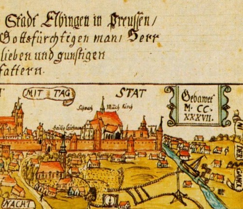
They arrived in Elbing, Prussia, in the evening. According to our traveller, the city was small, well fortified and close to the sea. Many English merchants lived there and traded in textiles with Danzig, Poland and other places.
Elbing was, beside Danzig, one of Prussia’s main economic centres. Trade had a long history in the area. Just south of the city, on Lake Drużno, the Viking Age trade settlement of Truso had existed since probably the seventh century. The settlement was abandoned when the lake’s connection to the Baltic Sea silted up.
Economically, Danzig became the major port in the area. But in the 1230s, the Teutonic Order, which had just gained a foothold in the region, founded Elbing. Like Danzig, Elbing became a member of the Hanseatic League, joined the Prussian Confederation against the Teutonic Knights in 1440, and, with the Second Peace of Thorn (1460), became a free city subject only to the Polish King.
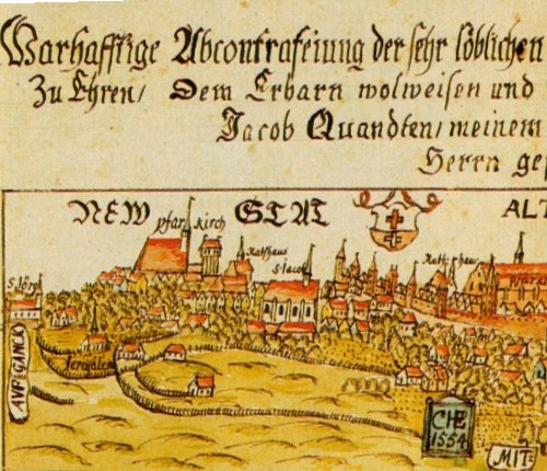
Before Caspar Henneberger made his map of Prussia, he drew a panoramic view of Elbing:

Through Prussia
Kiechel spent one day in Elbing and left on 8 June, travelling by carriage with a Prussian man and two men from Silesia. At noon, they arrived in Braunsberg (Braniewo) and in the evening in the village of Brandenburg (Ushakovo). The road was good and flat, passing through pleasant countryside. Kiechel wrote that Braunsberg was still in Prussia, whereas Brandenburg belonged to the Margrave of Brandenburg and Anspach.
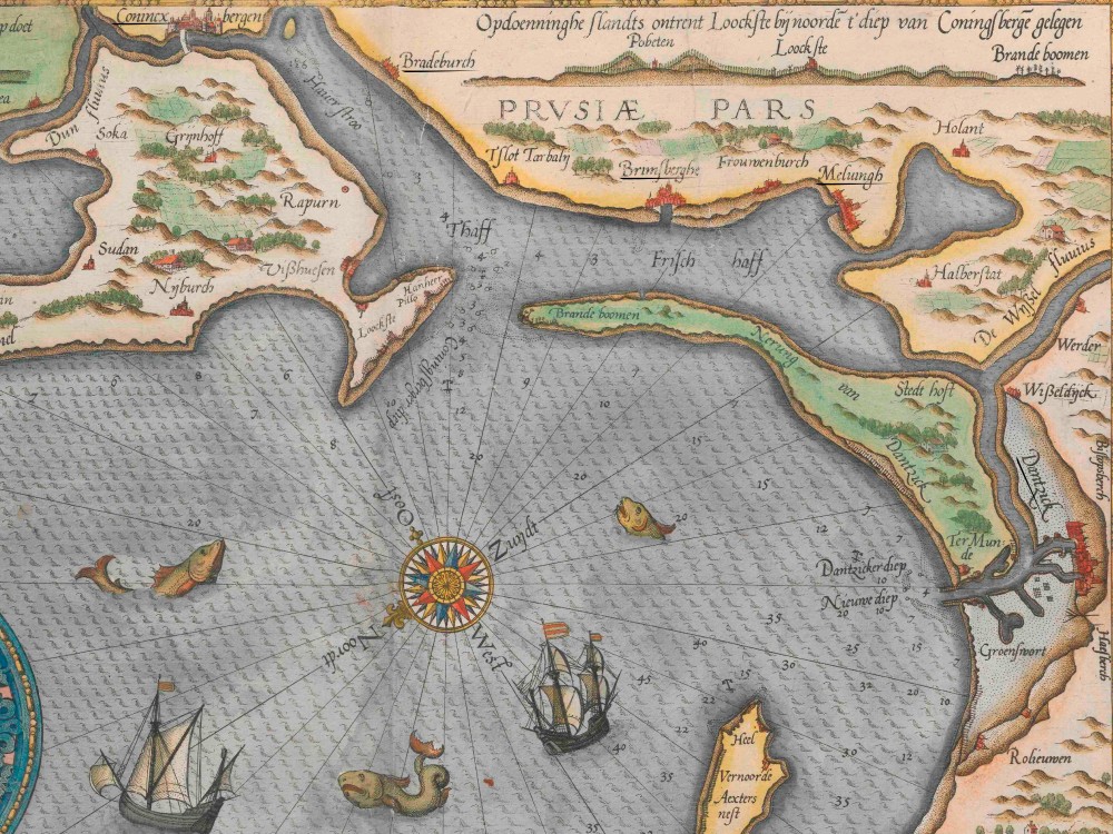
Naval chart of the Prussian coastline as seen from the north-west, including Danzig (“Dantzick”), Elbing (“Meluingh”), Braunsberg (“Brimsberghe”), Brandenburg (“Bradeburch”) and Königsberg (“Conincx bergen”)
Both Braunsberg and Brandenburg were actually in Prussia. However, the Prussian territory had been divided in 1525. The western part came under the direct rule of the King of Poland, whereas the eastern parts formed the Duchy of Prussia.
Samuel Kiechel and his companions spent the night in Brandenburg and continued the following day to Königsberg (Kaliningrad), arriving around lunchtime.
Königsberg and the Teutonic Order
Königsberg had been founded in the thirteenth century by the Teutonic Knights. Its location on the river Pregel, close to the Vistula Lagoon and the Baltic Sea, had already been the site of a settlement of a Prussian tribe. The city was named in honour of King Ottokar II of Bohemia (1233-1278), who had been on crusade against the Old Prussians with the Order.
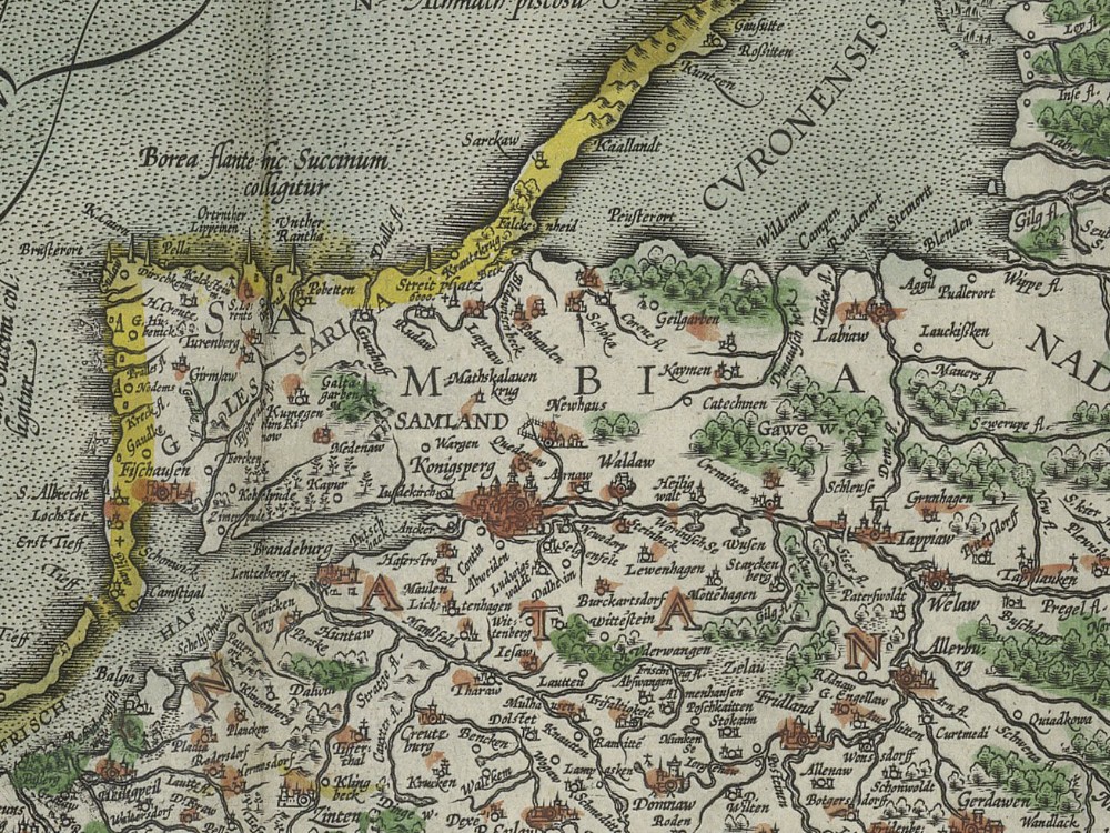
Königsberg and its surrounding area, including the Sambia Peninsula and the Curonian Lagoon
The location for Königsberg was well chosen. North of the city lay the Sambia Peninsula, followed by the Curonian Lagoon and the mouth of the Neman River (Memel, Niemen, Nemunas). The Teutonic Knights were engaged in a long-running war with the Prussians and Lithuanians that would last for more than a century, and the large Neman River provided access to the wilderness, a wide stretch of borderland between the territory of the Teutonic Order and the Grand Duchy of Lithuania. Along the river, the Knights would construct a string of castles as forward bases and border posts. Königsberg became the seat of the Marshal of the Order, who was tasked with organising the annual military expeditions eastward. Besides Marienburg Castle (Malbork), the seat of the Grand Master of the Order, Königsberg became the second most important centre of power in Prussia.
However, after the union between Poland and Lithuania and the conversion of the Lithuanians to Christianity, the Order came under increasing pressure. It could no longer claim to defend Christianity from the heathens. Long-held grudges and territorial disputes about the wilderness and Samogitia led to war, and in 1410, the Knights were decisively defeated at Grunwald (Tannenberg). The defeat set the Teutonic Order’s decline in motion. After another conflict with Poland-Lithuania, which was supported by the cities of the Prussian Confederation (Thirteen Years’ War, 1454-1466), it lost its western territories, including Marienburg Castle. The eastern part of Prussia became a Polish fiefdom. Königsberg was now the new seat of the Grand Master.
In 1525, Grand Master Albrecht von Brandenburg-Ansbach (1490-1568) introduced the Reformation in Prussia. He secularised the territory, turning it into a Duchy with himself as the first Duke of Prussia. The territory remained a fiefdom of the Polish crown, a precondition for King Sigismund I (1467-1548) to consent to the change. Königsberg became the capital of the Duchy of Prussia.
Königsberg in the 1580s
Our traveller described Königsberg as a large but not heavily fortified city. It has three parts: the Old Town, Kneiphof and Löbenicht. Each part of the city has its own council and jurisdiction. The river Pregel (Pregolya) flows through Königsberg. It comes from Lithuania, and much grain arrives on it. But the amount cannot be compared to the grain trade in Danzig (Gdańsk). A few miles from Königsberg, the Pregel flows into the Baltic Sea. Ships can sail up the river to the city to load and unload, but the ships that arrive are not very large.1
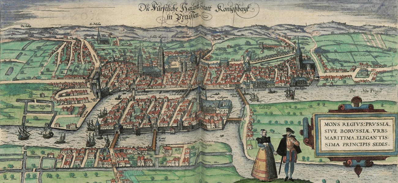
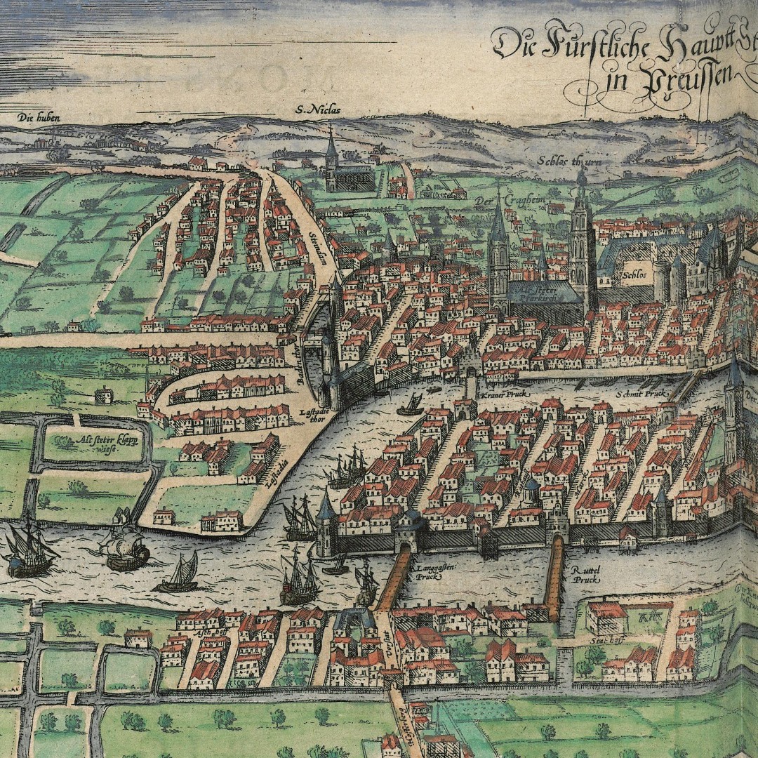
A bird’s-eye view of Königsberg appears in volume three of the Civitates Orbis Terrarum. As Kiechel wrote, the city is presented as a sprawling place with numerous suburbs but almost no fortifications. Of the three parts of Königsberg, Kneiphof is on the island at the centre of the view. The cathedral of Königsberg is on the upper-right edge of the island.
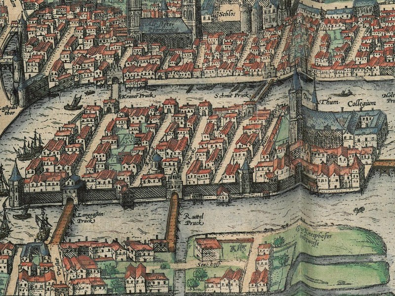
Königsberg-Kneiphof with the Cathedral (“Thum”) and University (“Collegium”)
The Old Town lies directly north (above) of Kneiphof, on the other side of the river, and Löbenicht is the eastern part (right side) of the city, around the Church of St. Barbara. The Pregel River flows through the city, and the many ships depicted on it underscore the importance of Königsberg as a regional trading port.
The view of Königsberg is very informative. Not only are the important buildings identified by name, but also the bridges across the river, streets and various other parts of the city (such as meadows and a lake).
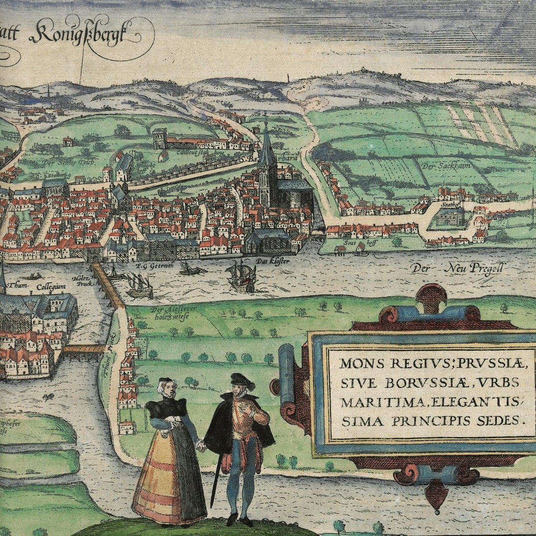
Kiechel continued in his journal: In Königsberg is the palace of the Margrave Georg Friedrich of Anspach, a large, wide and old building. Beside the palace, a large house was under construction. It was already very high. The ground floor was to contain an armoury, and the middle of the building was to be a church. But part of the construction had already collapsed. Our traveller mused that perhaps an armoury and a church did not belong in the same building. Kiechel also noted that he saw an epitaph to Margrave Albrecht in the cathedral of Königsberg, as well as one for Margrave Georg Friedrich.2
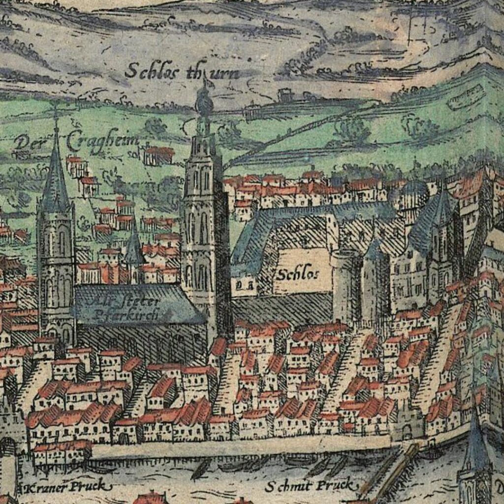
The palace in Königsberg (“Schlos”)
The Duke of Prussia was Albrecht Friedrich (1553-1618), who had financed Caspar Henneberger’s map. But Albrecht Friedrich increasingly suffered from depression and mental disorders and was declared unfit to rule. His next male of kin (cousins), Margrave Georg Friedrich of Brandenburg-Ansbach (1539-1603), took over the administration of Prussia. In 1578, the Polish King Stephen Báthory (1533-1586), as feudal overlord, granted him the province of Prussia as a fief.
An epitaph is an inscription on a tomb or gravestone. Because Samuel Kiechel explicitly mentioned an epitaph for the current margrave, who was still alive at the time, our traveller may have mistaken the coat of arms he had seen for an epitaph. In the Middle Ages, the cathedral of Königsberg was renowned for the many coats of arms painted on its walls. As the starting point for many of the Teutonic Orders’ military campaigns against the then-still-heathen Lithuanians, Königsberg attracted many Christian knights from across Europe who wanted to participate. Their coats of arms were painted in the cathedral to commemorate their visits. The second epitaph Kiechel mentioned likely belonged to Albrecht von Brandenburg-Ansbach, the last Grand Master of the Teutonic Order in Prussia and founder of the Duchy.
Samuel Kiechel also noted that amber is found along the Baltic coast around Königsberg. The amber is washed up to the shore by the sea, and all pieces found belong to the margrave. No one is allowed to collect amber under threat of corporal punishment, except the people appointed to do so. The trade in amber is very lucrative, particularly with Turkey (the Ottoman Empire).3
Amber was a highly profitable trade commodity in Prussia, and the area has been renowned for it since ancient times. Tacitus wrote in his Germania in the first century AD that a tribe called the Aesti lived on the right shore of the Baltic Sea (Mare Suebicum) and collected and traded amber.4
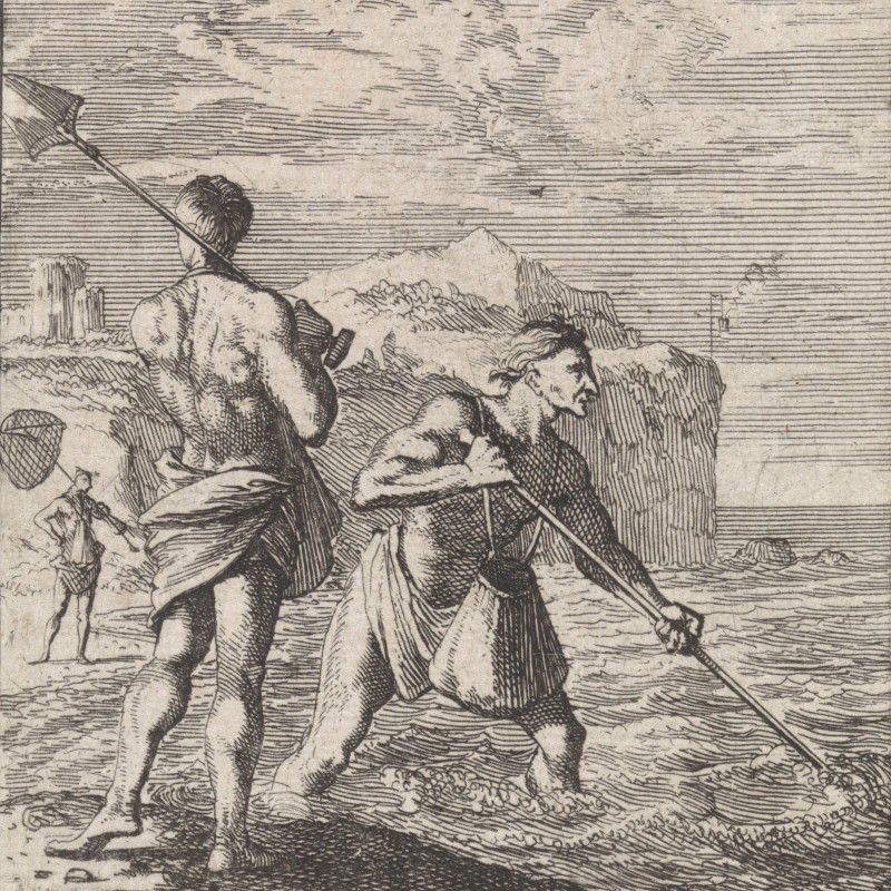
Amber collectors
Due to its value, the Teutonic Order and, later, the Dukes of Prussia established a monopoly over all amber found along the Prussian shore of the Baltic Sea. As Kiechel wrote, no one was permitted to collect amber privately or trade in it. If people found amber on the beach, they had to hand it over. The right to collect amber was granted to certain individuals, initially fishermen, on the condition that they sold everything they found to the Order or the Duke’s representatives. The penalty for illegal possession of amber ranged from hefty fines to death.
Local Stories
Caspar Henneberger, the pastor who had made the first modern map of Prussia, had also published a book explaining his map and providing readers with additional detail about the places marked on it. In addition to the historical background for the cities and castles, he occasionally included timely news and stories he had heard. He wrote that in 1585, the year before Kiechel’s visit, an unusually large number of wild geese had appeared around Königsberg, and the citizens wondered where they had come from. They were not grey, as wild geese in Prussia usually were, but more colourful. The geese descended on the fields and meadows, and many were concerned about the damage they might do there.5
Today, this is a bit of a non-story, but Henneberger considered it worth mentioning.
Henneberger also wrote about a custom among the butchers in Königsberg. They make a very long sausage for New Year’s Day, which is carried through all three parts of the city and then presented to the bakers. In 1583, the sausage was made from thirty-six pig legs. It weighed 434 pounds (ca. 200 kg), was 596 cubits long (ca. 357 m), and was carried by 91 people. The master butchers, their journeymen and apprentices, were all dressed in clean, white clothes, and the first man in the line had the sausage slung around his neck a few times. The others followed in line, carrying it on their shoulders. The last in line also had the end of the sausage slung around his neck. However, such a long sausage is not made every year; it is too expensive.6
Departure
Samuel Kiechel spent eleven days in Königsberg. The inn where he stayed was called “Golden Crown”, an unpleasant place with bad food. A fair was held in the city at the time, and Kiechel noted that he could not find companions until it was over.
During his stay in Königsberg, our traveller fell ill. He wrote that he felt unwell and cold, and that he thought he had a fever. Samuel had to lie down, but luckily felt better the next day.
Eventually, he met a Lithuanian merchant who was on his way back to Grodno (Hrodna) and together, they left Königsberg on 21 June.
Illustrations & References
All images are in order of appearance with links to sources on external websites:
- Königsberg, in: Braun, Georg, Hogenberg, Frans: Civitates Orbis Terrarum (3), Cologne 1593, fol. 43v; Heidelberg University.
- Nolpe, Pieter, Landschap met een boerderij aan een weg, 1623 – 1653; Rijksmuseum Amsterdam.
- Henneberger, Caspar, Warhafftige Abcontrafeiung der sehr löblichen Stadt Elbingen in Preussen, Archiwum Państwowe w Gdańsku; image from Wikimedia Commons.
- Waghenaer, Lucas Jansz., Teerste [-tweede] deel vande Spieghel der zeevaerdt, Leiden 1585, pt. 2, fol. 15v; Utrecht University Repository.
- Ortelius, Abraham, Theatrum Orbis Terrarum, 1606, fol. 99v; Folger Shakespeare Library.
- Königsberg, in: Braun, Georg, Hogenberg, Frans: Civitates Orbis Terrarum (3), Cologne 1593, fol. 43v; Heidelberg University.
- Luyken, Caspar, Der Agtstein-Fischer, 1711; Rijksmuseum Amsterdam.
- Die Reisen des Samuel Kiechel aus drei Handschriften, K. D. Haszler (ed.), Stuttgart 1866, p. 98; Bayerische Staatsbibliothek. ↩︎
- Reisen des Samuel Kiechel, pp. 97f ↩︎
- Ibid., p. 98. ↩︎
- Lindauer, Josef (ed.), P. Cornelius Tacitus, Germania. Bericht über Germanien, Munich 1991, p. 64. ↩︎
- Henneberger, Caspar, Ercleru[n]g der Preüssischen grössern Landtaffel oder Mappen. Mit leicht erfindung aller Stedte, Schlösser, Flecken, Kirchdörffer, Orter, Ströme, Fliesser vnd See so darinnen begriffen, Königsberg 1595, p. 192; Bayerische Staatsbibliothek. ↩︎
- Ibid., pp. 190f. ↩︎