Journal of Samuel Kiechel
21 – 25 June 1586
From Königsberg to Grodno
“We left on the 22nd in the morning and drove along a good track. The land was flat, the weather dry and warm. I was astonished by the heat, as we travelled mostly through forests and rarely saw the sun.”
Die Reisen des Samuel Kiechel aus drei Handschriften, K. D. Haszler (ed.), Stuttgart 1866, pp. 98f; Bayerische Staatsbibliothek.
From Königsberg to Grodno (Hrodna)
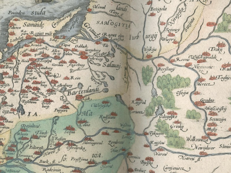
Map of Prussia and Poland with Königsberg (“Regius mons”) and Grodno
Samuel Kiechel left Königsberg (Kaliningrad) on 21 June with a Lithuanian merchant and innkeeper. The man’s name was Hanns Hülcowüz; he lived in Grodno (Hrodna) and was on his way home after visiting the Königsberg fair. He had his own carriage, coachman and horses. The carriage carried various goods he had bought in Königsberg.
In the evening, Kiechel and his new companion arrived in the village of Lamgarben (Garbno). The place was still within the Duchy of Prussia, but Kiechel noticed that its inhabitants already spoke Lithuanian.
Lamgarben was about eighty kilometres south-east of Königsberg and some distance from Lithuanian territory. While Lithuanian migrants may have settled there, it is far more likely that the population spoke Old Prussian, and Samuel Kiechel mistook it for Lithuanian. The Old Prussian language had been in decline since the Teutonic Knights conquered and subdued the Prussian tribes, but it continued to be spoken in eastern Prussia. It would die out in the eighteenth century. Lithuanian and Old Prussian belong to the same family (Baltic languages). Unfamiliar with both languages, Kiechel would not have been able to tell the difference.
The two travellers continued the following day along a good road through flat countryside. The weather was very hot, and Kiechel was surprised by the heat because they travelled through a large forest and the sun rarely managed to break through the foliage. In the evening, they arrived in a village called Schilaschach (?) in Lithuania. Kiechel noted that the area belonged to the Kingdom of Poland.
They left the village very early the next morning and travelled until around 9 o’clock, when the heat of the day became too much. The previous day, the horses had refused to move on more than one occasion because of the heat. The animals were exhausted and harassed by large gadflies. The travellers stopped in a small hamlet and remained there until evening. When the temperature had dropped to a bearable level, they continued, driving through the night and arriving early the next morning in the town of Augustów in Lithuania.
Again, Kiechel and his companion stayed in the town during the day and continued in the evening. They drove throughout the night through a large forest. At around 2 o’clock in the morning, they arrived at a tavern on the other side of the forest, where they took a break. But because they could not find anything to eat and wanted to reach Grodno before the day got too hot again, the two men left shortly after. Kiechel’s companion was worried about the condition of his horses, as the road was deep and sandy, and it took considerable effort to pull the carriage.
After another four miles of travelling, Kiechel and Hanns Hülcowüz finally arrived in Grodno.
The Wilderness
Samuel Kiechel mentioned that a dense forest covered the landscape he travelled through from Königsberg to Grodno. In sources from the fourteenth and early fifteenth centuries, the area is described as a ‘wilderness’.1 According to the sources, it was a densely forested, marshy region interspersed with open meadows. Many small rivers and streams flowed through it. It was the last primaeval forest of ancient Europe. Initially, the area was dotted with small settlements and hillforts of the Prussian tribes, but it was depopulated during the protracted conflict between the Teutonic Order and Lithuania, as the constant threat of raids or of whole armies passing through made life untenable. The Knights began to establish a network of castles in the wilderness as forward bases, watchposts and early defences against Lithuanian raids.2
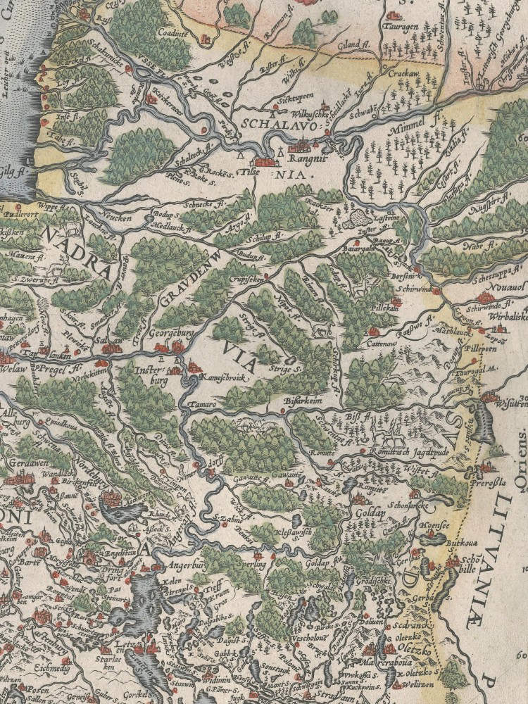
The wilderness on Caspar Henneberger’s Prussiae-Map
Sources from the Middle Ages and the first century of the early modern period are not particularly known for detailed and accurate landscape descriptions. Traveller’s journals focused mostly on the settled places and largely omitted the spaces between them.3 Kiechel is already something of an exception for writing about his time on the road. But his descriptions of the landscapes barely go beyond noting whether they were pleasant, beautiful or desolate.
So how do we know about the wilderness?
Historical background
The Teutonic Order was founded in 1198 in Acre, in the aftermath of the Third Crusade. In 1226, Duke Konrad of Masovia (1187-1247) called upon the Order to fight the heathen Prussians, a conglomerate of tribes living along the Baltic coast between the Vistula and Neman Rivers. The Knights agreed and secured their position in the region by asking Emperor Frederik II (1194-1250) to grant them all the Prussian territory they conquered (Golden Bull of Rimini, 1226). They established their own territorial domain in Prussia and expanded into Livonia in 1237 after the Brothers of the Sword, another Christian order, were defeated by the Lithuanians and incorporated into the Teutonic Order.4
After the Prussians were finally subjugated in 1283, the Teutonic Knights turned their attention to Lithuania. However, Lithuania had been unified by the Gediminid dynasty in the early fourteenth century and had expanded eastward into the territories of the former Kyivan Rus’. Protected by a wide belt of swampy wilderness, the Lithuanians offered far greater resistance to the Teutonic Knights’ attacks than the Prussian tribes. Lithuania remained the last pagan empire until its Union with Poland in 1585/86, when the Lithuanian Duke Jogaila (1352-1434) became the Polish King Władysław II Jagiełło.5
In their war with the Lithuanians, the Teutonic Order organised regular military campaigns from Königsberg to Samogitia (Lower Lithuania, the land north of the Memel between Kaunas and the Baltic Sea) and to Lithuania. Although often stylised as crusades against heathens, the sources clearly suggest that many of those campaigns were just raids. However, a marshy wilderness was not the ideal ground for heavily armoured knights, so speed and surprise were of the essence. The Knights had to get through the wilderness quickly, before the Lithuanians could organise a defence or, worse, lay ambushes. As in military campaigns today, intelligence was key. The Knights sent out scouts to mark routes through the wilderness and identify worthwhile targets in Samogitia and Lithuania for an attack.6
Scouting the Wilderness
The Teutonic Order was a medieval model of bureaucracy. The scouts, upon returning from their missions, reported their findings. Slips of paper, so-called ‘czedelln’7 or ‘czedelichen’8, were a common way to communicate information and news within the Order. They were used similarly to notepaper and occasionally reused. The slips of paper would be enclosed in a letter and then sent off. The scout’s reports were written on such slips of paper and sent to Königsberg, the seat of the Marshal of the Teutonic Order, where the campaigns were organised. With the help of those reports, routes and targets were chosen. But many of the reports were also copied into the knights’ ledgers, and 101 of them have survived.9
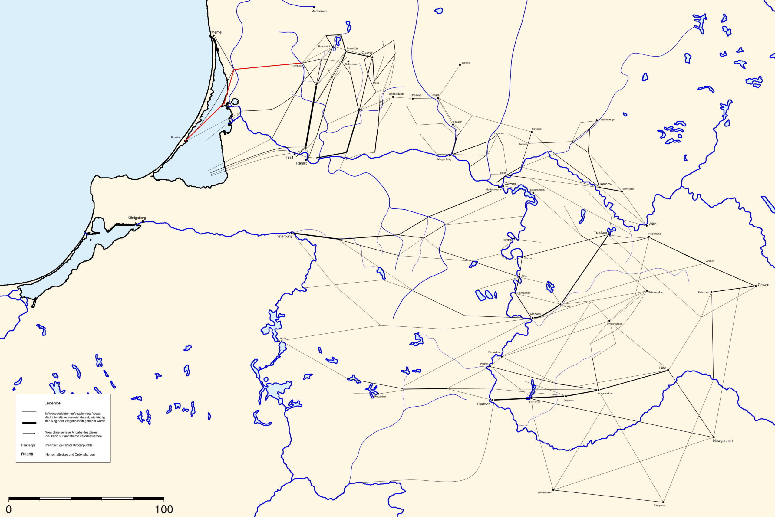
Reconstruction of the scout’s routes through the wilderness
The scout’s reports cover an area that, in modern terms, stretches from the coast of the Baltic Sea (around Klaipėda and the Curonian Lagoon) in the north-west to Novogrudok in Belarus in the south-east. The reports are matter-of-fact. They name waypoints, places for possible campsites, mention the distances between them and the landscape and obstacles, as well as the work needed to clear them. The waypoints in the wilderness are usually rivers and brooks, and the distances are guesswork. The reports contain the names of over 100 streams, lakes, swamps, meadows and stretches of woodland and over 200 villages, farmsteads and fortifications. The settlements and fortifications were usually in Samogitia and Lithuania.10
The obstacles and the work required to clear them provide a clear indication of the landscape’s character. Advice such as clearing undergrowth for a certain number of miles, building a bridge across a stream, or constructing a simple log road to cross a swamp is regularly found in the reports. The scouts also noted whether the ground was solid enough to support the weight of a war party with all its armour and baggage, or too soft and dangerous.11
In addition, the reports contain the names of about 150 scouts of the Teutonic Order. The scouts were largely Prussians and Lithuanians. Many names in the reports are therefore of Baltic origin (Old Prussian or Lithuanian) and were adopted by the Knights.12
There are no cardinal directions in the reports. While useless for actually finding your way through the wilderness, those scouts’ reports were valuable for the logistical planning of a military campaign and, today, for historians to learn about the wilderness.13
The Wilderness in the Fifteenth and Sixteenth Centuries
After the union between Poland and the Grand Duchy of Lithuania in 1385/86 and the decline of the Teutonic Order, the wilderness was reclaimed, though the process was slow. The area remained a major physical obstacle, with no established roads and very few settlements. The border through the wilderness, established between the Order and Poland-Lithuania in 1422 (Treaty of Lake Melno), is considered one of the longest-lasting borders in European history, remaining unchanged until the early twentieth century. It was, however, in continual dispute until 1545.
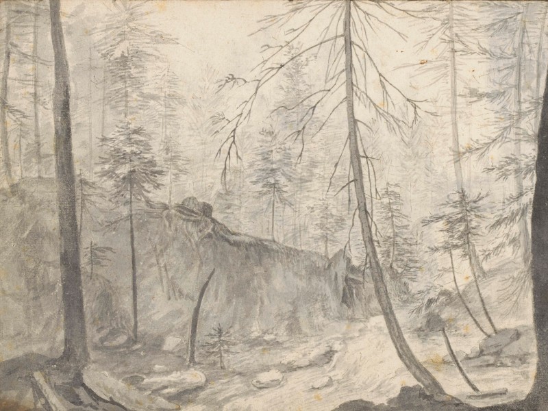
The wilderness around Veliuona on the Neman River in 1655
The wilderness, a focal point of the long conflict between the Order and Lithuania, became, with the treaty, a periphery. While there was interest in opening up the region economically, building settlements and pushing roads through, the necessary financial resources were not readily available. In addition, the waves of settlers that had moved east in the Middle Ages had dried up.14
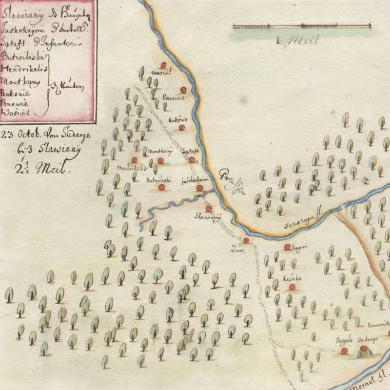
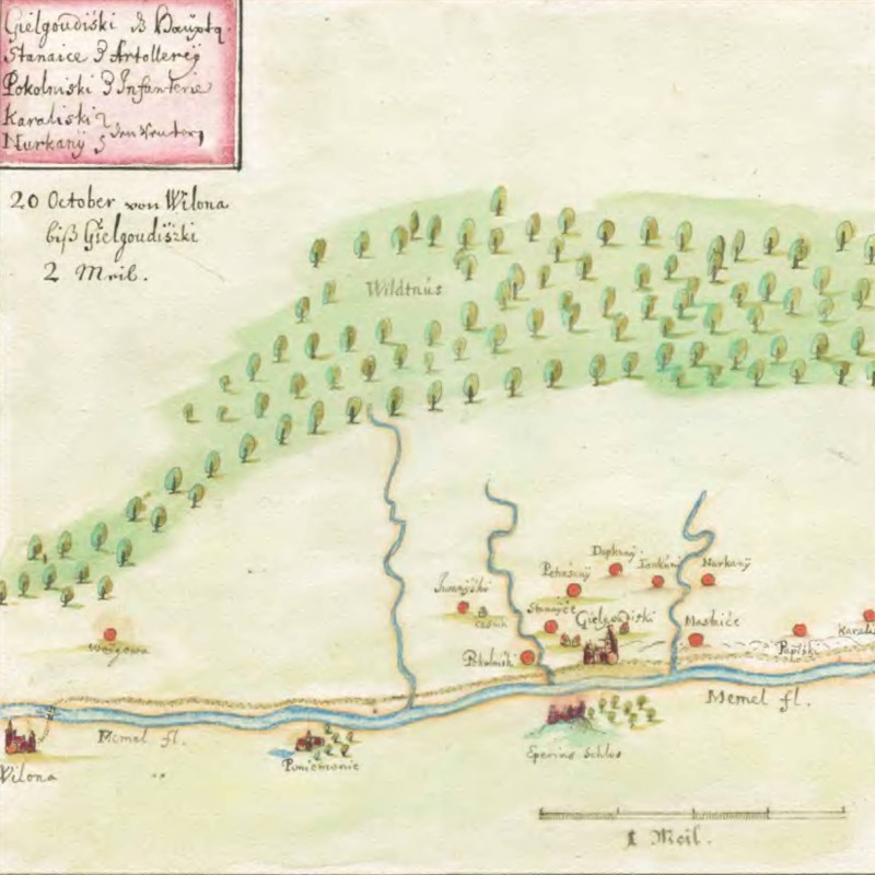
The wilderness between the Neman and Šešupė Rivers in 1655
New settlements were established, and the town of Augustów, where Kiechel stopped on his way through the wilderness, was such a newly founded place. But, as our traveller mentioned, there were still long stretches of uninterrupted forest. The area’s isolation led to a lack of central control, and the local administrators in the settlements often acted arbitrarily. Among the German, Polish and Lithuanian settlers in the wilderness, complaints, accusations and assaults were not uncommon. The region also became a popular place for smugglers. For the Polish Kings and the nobility, the wilderness became one of the foremost hunting grounds due to its abundance of large game animals, including bears, aurochs and European bison.15
The continued existence of large stretches of wilderness in the late sixteenth and seventeenth centuries is evident on Caspar Henneberger’s map and on Swedish sketch maps from the mid-seventeenth century. While most of the wilderness has disappeared today, the Białowieża Forest on the border between modern Poland and Belarus is the last remaining stretch of this ancient forest.
Illustrations & References
All images are in order of appearance with links to sources on external websites:
- van Uden, Lucas, Boslandschap, 1605 – 1673; Rijksmuseum Amsterdam.
- Ortelius, Abraham (ed.), Theatre of the World, Antwerp 1587, fol. 86v; Library of Congress.
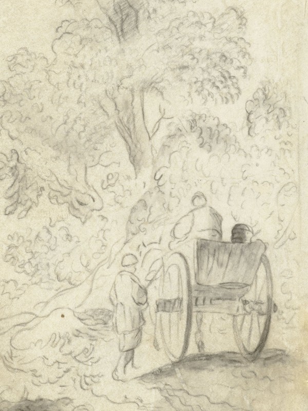
- de Molijn, Pieter, Kar met twee figuren op een landweg langs een bos, 1610 – 1660; Rijksmuseum Amsterdam.
- Ortelius, Abraham (ed.), Theatre of the World, Antwerp 1587, fol. 87v; Library of Congress.
- Striegler, Stefan, Reconstruction of the scout’s routes through the wilderness, 2010.
- van Vianen, Paulus Willemsz., Sunken Path through an Evergreen Forest, 1603; Rijksmuseum Amsterdam.
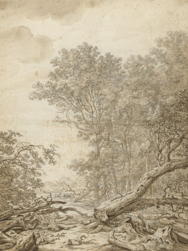
- Saftleven, Herman, Hoog Soerensche Bosschen bij Apeldoorn, 1640 – 1649; Rijksmuseum Amsterdam.
- Anonymous, 20 October von Wilona biss Gielgoudiszki 2 Meil., 1655; Swedish National Archives, Stockholm.
- Anonymous, 23 Octob. von Sudarge biss Slawianÿ 2 1/2 Meil., 1655; Swedish National Archives, Stockholm.
- „wiltnisse der heren von Prusen“, in: Aussagen alter Leute über die Ausdehnung des D. Ordensgebietes an der Grenze Samaitens, in: Hirsch, Theodor, Toeppen, Max, Strehlke, Ernst (eds.), Scriptores Rerum Prussicarum – Die Geschichtsquellen der Preussischen Vorzeit bis zum Untergange der Ordensherrschaft, Vol. 2, Leipzig 1863, pp. 709–711. Joachim Erich (ed.), Marienburger Tresslerbuch der Jahre 1399–1409, Königsberg, Bremerhaven 1896 (reprint 1973), pp. 98, 115, 238, 408. ↩︎
- Striegler, Stefan, Raumwahrnehmung und Orientierung im südöstlichen Ostseeraum vom 10. bis 16. Jahrhundert. Von der kognitiven zur physischen Karte,
Stuttgart 2018, pp. 70-86. ↩︎ - Gotthard, Axel, In der Ferne. Die Wahrnehmung des Raumes in der Vormoderne, Frankfurt/Main 2007. ↩︎
- Militzer, Klaus, Die Geschichte des Deutschen Ordens, Stuttgart 2005; Murray, Alan V. (ed.), The North-Eastern Frontiers of Medieval Europe. The Expansion of Latin Christendom in the Baltic Lands, Farnham 2014. ↩︎
- Rowell, Stephen C., Lithuania ascending. A pagan empire within east-central Europe, 1295-1345, Cambridge 1994. ↩︎
- Paravicini, Werner, Die Preußenreisen des europäischen Adels, 2 Vol., Sigmaringen 1989, 1995. ↩︎
- Geheimes Staatsarchiv Preußischer Kulturbesitz (GStA PK), Berlin, XX. HA, Ordensbriefarchiv (OBA), Nr. 561, Hochmeister an den M. in Livland betreffend den Friedensschluß mit Wytowdt, April 1398. ↩︎
- Prochaska, Antoni (ed.), Codex Epistolaris Vitoldi Magni Ducis Lithuaniae 1376–1430, Kraków 1882, p. 192, no. 425. ↩︎
- Striegler, Stefan, Die „Littauischen Wegeberichte“ – Rekonstruktion und Konstruktion eines historischen Grenzraumes, Greifswald 2010 (Master’s thesis, unpublished). ↩︎
- Striegler, Stefan, Raumwahrnehmung und Orientierung, pp. 70-86; Striegler, Stefan, Die Große Wildnis im 14. Jahrhundert — Wahrnehmung und Beschreibung eines geografischen Raumes, in: Srodecki, Paul, Steindorff, Ludwig (eds.), Viele Welten des Ostseeraumes. Politischer, wirtschaftlicher und kultureller Austausch vom Hochmittelalter bis zum Beginn der Neuzeit, Marburg, 2024, pp. 223-235. ↩︎
- Ibid. ↩︎
- Ibid. ↩︎
- Ibid. ↩︎
- Rowell, Stephen C., The Lithuano-Prussian Forest Frontier, c. 1420–1600, in: Power, Daniel, Standen, Naomi (eds.), Frontiers in Question. Eurasian Borderlands, 700–1700, Hong Kong 1999, pp. 182-208. ↩︎
- Ibid. ↩︎