“I travelled with a Dutchman I had met in Hamburg, who carried a small bag just like mine. Together, we hired a third person to carry our bags. We walked towards Stade, assuming the man with our bags would follow us.“1
From Hamburg to Bremen
13 July – 15 July 1585
Samuel Kiechel left Hamburg on 13 July, heading for London. His journey to England took him along the North Sea coast, passing through the northern Dutch provinces to the port of Vlissingen. He planned to cross the Channel to Dover and then travel through Canterbury and Gravesend to reach London. This part of the journey was a round trip. Kiechel visited London via the independent Dutch provinces and returned through the Spanish Netherlands after spending two months in the English capital.
While Kiechel’s earlier account of his journey from Ulm to Hamburg was brief, he now began to record more observations about the places he visited along the way. Notably, he described his experiences in London with much greater detail than in previous cities visited.
Across the Elbe to Stade

Map of the Elbe River with Stade and Hamburg
On the day of his departure from Hamburg, Samuel Kiechel went to the harbour at lunchtime. During the summer, a large boat left for Stade every day, weather permitting. Stade was about thirty kilometres downstream from Hamburg on a tributary of the Elbe. Many people had already gathered on the quayside, and Kiechel boarded a vessel with around fifty other passengers.

The boat set off from Hamburg. Kiechel noticed that the wind conditions were unfavourable, preventing the use of the sails. Two men had to row the boat, pulling the oars for an hour before being replaced.
The wind originated from the west and grew stronger. Eventually, the boat could make no headway. The boatmen decided to steer their craft towards the riverbank. Kiechel and the other passengers had to disembark and continue their journey to Stade on foot.
Our traveller had left Hamburg accompanied by a Dutchman he had met in the city. Faced with the prospect of walking to Stade, they decided to hire another passenger to carry their bags. Kiechel noted that he had a small “fallis”.2
Until now, our traveller has not mentioned his luggage. The term “fallis” derives from the French word ‘valise’ (in German, it is also called Felleisen), which denotes a travel bag, backpack or saddlebag. It was typically made of leather. In Kiechel’s case, it may have been a shoulder bag with a strap. Considering he had walked part of the journey, this bag must have been small enough to carry easily.
Unburdened by their luggage, Kiechel and the Dutchman walked on towards Stade. They paid no further attention to the man carrying their bags, assuming he and all the other passengers from the boat would follow the same route.

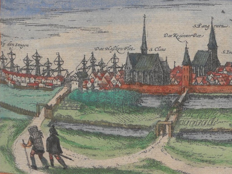
Stade
Stade is situated on the Schwinge, a river that flows into the Elbe four kilometres from the town. At the time of Kiechel’s visit, Stade was under the rule of the Bishop of Bremen. The place had been an important natural harbour since the early Middle Ages, but lost significance with the rise of Hamburg in the thirteenth century.


In this view, the city is wrongly labelled as Oldenburg. However, the names of the churches confirm it as Stade from a southern perspective. On the left side and above the houses, the masts of ships in the harbour can be observed.
Although our traveller does not give further details about the city, a bird’s-eye view can be found in the “Civitates Orbis Terrarum”. We see Stade from the south, fortified by a wall and a moat. A table in the lower right corner identifies thirty-three buildings within the city and various locations in the surrounding countryside. Municipal structures such as the weighing house, hospital, prison, and the town’s wine cellar are listed there.

View of Stade, 1598
The river Schwinge runs past the city, supplying the moat with water. Many smaller vessels and boats can be seen on it. At the upper edge of the image is the Elbe, with some ships shown sailing towards Hamburg.


In the bird’s-eye view, the land between the Elbe and Stade consists of fields and meadows bordered by rows of trees. Roads lead to the city from all directions, and Samuel Kiechel likely arrived via one of these routes.
Lost Luggage
Samuel Kiechel and his Dutch companion walked towards Stade but eventually realised that the man who had been carrying their bags was nowhere to be seen. Although suspicious of this absence, Kiechel felt powerless to do anything about it. It was already late in the day, and if the traveller did not want to spend the night outdoors, he needed to hurry. The gates of Stade would soon be locked.

Upon arriving in the city, Samuel Kiechel found that the guards had kept the gate open for half an hour longer than usual to wait for passengers from the boat. He asked the guards if they had seen a man carrying two bags. Unfortunately, the man had not yet arrived. Our traveller paid them a few coins to keep the gate open a little longer.
More passengers arrived, but the man carrying Kiechel’s bag was not among them. Eventually, the guards complained that they could not keep the gate open without permission from the mayor. Kiechel decided against spending the night outside the city and concluded that the man had run off with his bag. The guards closed the gate, and the traveller went to the inn in a foul mood.
While Kiechel was having dinner, a guard arrived at the inn. He informed our traveller that a man with two bags was waiting outside the gate. Kiechel followed the guard and discovered that this was indeed the man he had asked to carry his bag. Unbeknownst to our traveller, there were two routes from the riverbank to Stade, and some passengers, including this man, had taken the alternative route.
Unfortunately, the gate was closed and could not be reopened until the morning. The key to the gate was in the mayor’s possession for safekeeping. The man who had carried Kiechel’s bag would not be able to enter the city and had to spend the night outside.

Leaving the keys to the city gates with the mayor was common practice in many places in early modern Germany. This was part of the security measures designed to prevent anyone from covertly entering or leaving a city at night. Even bribing a guard to open a gate proved futile without the keys.
Fortunately, Kiechel spotted a gap between the cobbles and the gate. It was just wide enough to allow the bag to pass through. Relieved to reclaim his luggage, Samuel Kiechel paid the man and returned to the inn.
Bremen
Samuel Kiechel spent the night in Stade and left the following morning. He had met three Dutchmen, and together they hired a carter to take them to the village of Bremervörde. In Bremervörde, the travellers saw a large fortress surrounded by a moat, which belonged to the Bishop of Bremen.
Unwilling to stay in the village, the travellers convinced their carter to take them to Bremen. The road stretched across open heathland, forcing them to travel through the night. By morning, they reached a village just a mile outside Bremen. The travellers had breakfast and then continued into the city.

Kiechel observed that Bremen was an imperial city on the coast of the North Sea. Though not particularly large, it was a well-fortified and bustling trading port. The Weser flowed through Bremen, allowing ships to navigate up the river and anchor in the city’s harbour. The Bishop of Bremen resided there, and many Dutch people had settled there due to the freedom of religion.
Two views of Bremen are found in the “Civitates Orbis Terrarum.” Both depict the city from the southwest. The first image is a profile view and is relatively small. It shares the page with views of Brunswick, Lüneburg, and Oldenburg. This image can be traced back to a woodcut by Hans Weigel of Nuremberg in 1564.

View of Bremen, 1572
This view depicts Bremen as a fortified and densely populated city with numerous churches. In the foreground are the Weser River and ships of various sizes. A small part of the city along the bank of the Weser remains unfortified and seems to serve as Bremen’s harbour.
The origins of Bremen can be traced back to the Saxon Wars of Charlemagne in the eighth century. To promote Christianity among the subdued Saxons, Charlemagne established the Bishopric of Bremen in 788 and constructed a wooden church. When Vikings raided Hamburg around 845, the Archbishop of Hamburg fled and relocated to Bremen. The two dioceses were merged to form the Archdiocese of Hamburg and Bremen.

Map of the Weser Estuary
Due to its strategic position at the mouth of the Weser leading into the North Sea, Bremen developed into a significant trading hub. As Kiechel noted, ships could navigate up the Weser and safely anchor in the city’s harbour. In 1186, Bremen attained the status of a free and imperial city and, in 1260, became a member of the Hanseatic League.
In the following centuries, Bremen frequently found itself in conflict with its neighbours. The city’s prosperity depended on trade and free access to its harbour. The territory between the North Sea and the city was controlled by the Archbishop of Bremen, the Count of Oldenburg, and independent Frisian communities. All of them tried to partake in the lucrative sea trade by attempting to impose taxes on ships navigating up the Weser or resorting to piracy. To protect their autonomy and wealth, the citizens of Bremen needed to gain control over the mouth of the Weser from the North Sea to the city.
The Protestant Reformation reached Bremen in the mid-sixteenth century. From 1566 onwards, the bishop of Bremen was a Protestant elected bishop (administrator). The Dutch migrants mentioned by Kiechel were likely Protestants fleeing the war and religious persecution in the Netherlands. Many Dutch Protestants chose to leave their homeland and emigrate to neighbouring territories within the Empire. Among them were a considerable number of artisans, merchants, and artists.
Samuel Kiechel further notes that the river Rhine was blockaded, and all goods bound for Cologne, Westphalia, and other parts of this region had to be transported overland via Bremen. These goods included cheese, butter, stockfish, herring, and various other foodstuffs. Kiechel did not specify why the Rhine was blockaded, but it was likely due to either the Dutch War of Independence (1568-1648) or the Cologne War (1583-88).

Bird’s-eye view of Bremen, 1598
This bird’s-eye view depicts Bremen as a fortified city. A single wooden bridge crosses the Weser River. The city is densely populated, with numerous houses built close together. The churches and several municipal buildings are labelled by name.
Kiechel had arrived in Bremen from the east (the upper part of the bird’s-eye view). Upon leaving the city, he crossed the Weser on the wooden bridge shown in both images.
Illustrations & References
All images are in order of appearance with links to sources on external websites:
- Stade [misnamed as Oldenburg3], in: Braun, Georg, Hogenberg, Frans, Civitates Orbis Terrarum (1), Cologne 1593, fol. 23v; Heidelberg University.
- Ortelius, Abraham, Theater of the World, Antwerp 1587, fol. 49v; Library of Congress.
- Brueghel, Jan, View of a City along a River, c. 1630; Rijksmuseum Amsterdam.
- Saftleven, Herman, Man met twee zakken en een man met een grote kist, 1619 – 1685; Rijksmuseum Amsterdam.
- Stade, in: Braun, Georg, Hogenberg, Frans, Civitates Orbis Terrarum (5), Cologne 1599, fol. 40v; Heidelberg University.
- Waterloo, Anthonie, Stadspoort te Hamburg (?), 1619 – 1690; Rijksmuseum Amsterdam.
- Merian, Matthäus, Nachtelijk vertrek bij een herberg, 1603 – 1650; Rijksmuseum Amsterdam.
- Saftleven, Herman, Landschap met een kasteel, 1619 – 1685; Rijksmuseum Amsterdam.
- Bremen, in: Braun, Georg/Hogenberg, Frans, Civitates Orbis Terrarum (1), Cologne 1593, fol. 23v; Heidelberg University.
- Ortelius, Abraham, Theater of the World, Antwerp 1587, fol. 44v; Library of Congress.
- Bremen, in: Braun, Georg/Hogenberg, Frans, Civitates Orbis Terrarum (5), Cologne 1599, fol. 41v; Heidelberg University.
- Die Reisen des Samuel Kiechel aus drei Handschriften, K. D. Haszler (ed.), Stuttgart 1866, p. 11; Bayerische Staatsbibliothek. ↩︎
- Ibid. ↩︎
- Füssel, Stephan: Natura Sola Magistra — Der Wandel der Stadtikonografie in der Frühen Neuzeit, in: Braun, Georg & Hogenberg, Franz: Civitates Orbis Terrarum — Städte der Welt, Katalog der Stadtansichten (Füssel, Stephan & Althoff, Joahnnes, eds.), Cologne 2015, p. 133. ↩︎