Journal of Samuel Kiechel
26 – 29 July 1585
From Harlingen to Amsterdam
“At night, the wind picked up significantly. I found myself wishing I was back on land. The ship began to cross back and forth against the wind. The weather did not change the following morning, forcing us to spend the day and the next night at sea.“
Die Reisen des Samuel Kiechel aus drei Handschriften, K. D. Haszler (ed.), Stuttgart 1866, p. 15; Bayerische Staatsbibliothek.
Leaving Harlingen
Samuel Kiechel did not spend any time in Harlingen. Upon his arrival, he learnt that a ship was about to depart for Amsterdam and decided to continue his journey. According to our traveller, one or two ships depart from Harlingen for Amsterdam each week. He also heard that the trip would take only eight to nine hours with favourable winds. So, Kiechel bought just a piece of bread as provisions and went aboard. Approximately sixty passengers were already on the vessel.
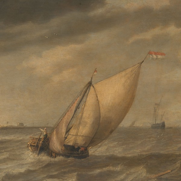
The ship departed from Harlingen, but after about two miles, the wind shifted and pushed it back towards the harbour. However, despite the adverse winds, the vessel’s owner was reluctant to turn back. Kiechel explained that the ship needed to arrive in Amsterdam at a specific time, regardless of the wind conditions. The owner and crew would not get paid if they fell behind schedule.
The ship continued to sail against the wind throughout the night. The sea grew rougher, and our traveller wished he were back on land. When morning broke, the weather had not improved. The ship kept sailing against the wind all day and through the following night.
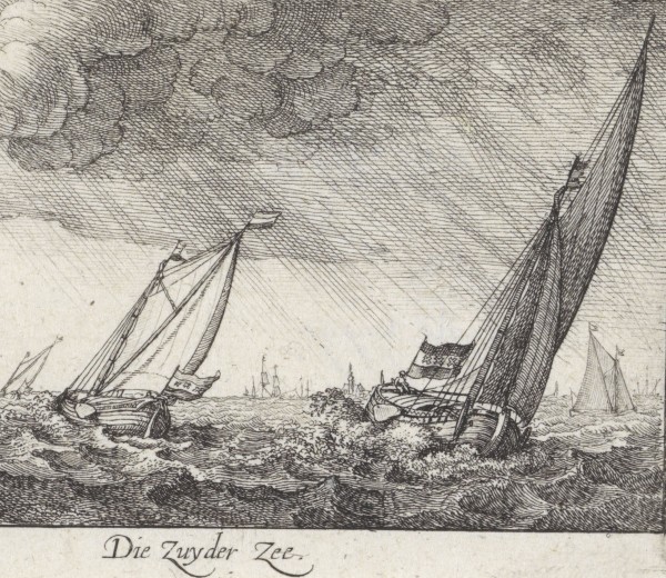
The Zuiderzee
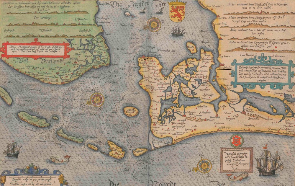
Naval chart of the Zuiderzee, 1585
Harlingen was an important Frisian port at the entrance to a large basin known as the Zuiderzee, a vast bay of the North Sea that extended deep into the Netherlands. A chart in the Spieghel der zeevaerdt depicts the Zuiderzee and its coastlines. The chart is oriented towards the east-southeast, placing Harlingen on the left side of the image along the coast. Amsterdam is situated at the northwestern end of this bay (the right side of the chart). The Ij, an arm of the Zuiderzee, serves as the sole maritime route to access Amsterdam.
Today, this bay no longer exists. In the nineteenth century, a canal was constructed to extend the Ij to the coast, providing Amsterdam with direct access to the North Sea. Simultaneously, the construction of a dam and the Oranjesluizen (Oranje locks) separated the Ij from the Zuiderzee. In 1932, the completion of the Afsluitdijk, a thirty-two-kilometre-long dam, sealed off the Zuiderzee and created the IJsselmeer. Over half of the land that the Zuiderzee once covered has since been drained, and the IJsselmeer is now a significantly smaller body of water. Remarkably, the reclaimed area is the world’s largest land-based ship graveyard.1
Due to its size and strategic location, the Zuiderzee was the central hub for Dutch maritime traffic, including regional trade, transport and international shipping, during the early modern period. Not only did ships of the Dutch East India Company (Vereenigde Oostindische Compagnie) pass through it on their way to the Dutch colonies in Asia, but vessels engaged in Baltic Sea trade also used it. While the colonial exploits are more widely known, the trade in Northern Europe generated the wealth that facilitated them. Ships destined for Hanseatic towns such as Zwolle, Deventer and Kampen could only reach them via the Zuiderzee.2
Navigating the Zuiderzee
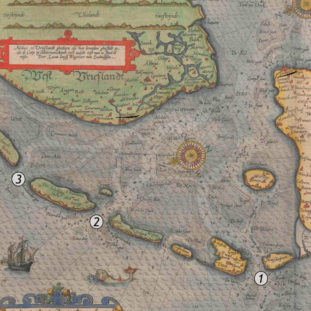
The entrance to the Zuiderzee: (1) Marsdiep, (2) Vlie, (3) Amelander Zeegat
Access to the Zuiderzee was through a funnel-like strait from the North Sea. The sea narrowed, forming the entrance to the Zuiderzee between Stavoren on the eastern coast and Enkhuizen on the western coast. This funnel was dangerous to navigate due to its sandbanks. There were three access routes for large ships: the Marsdiep (1), Vlie (2), and Amelander Zeegat (3). These channels were marked with buoys and barrels to ensure safe navigation.3
Once a ship had passed through the funnel and entered the Zuiderzee, the conditions differed from those in open sea. The tides were less pronounced because of the sandbanks at the entrance, and most of this vast bay was relatively shallow, with an average depth of three metres.4
The traditional method of marking sandbanks and mudflats involved placing beacons. These beacons consisted of long branches or bundles of branches stuck into the seabed. Buoys were used for the deeper shipping channels. The markers required regular maintenance. The city that was granted the privilege of maintaining them collected the Paalgeld from all ships on the Zuiderzee. The Paalgeld was a levy to finance the maintenance of the sea lanes.5
Lighthouse at Zandvoort, 1607
In addition to the buoys, familiarity with the coastline was vital for sailing through the Zuiderzee. Church towers and other recognisable structures served as points for orientation. When permanent landmarks were absent, temporary beacons, such as wooden scaffoldings, could be erected. At night, fires were lit on the shore to assist navigation. Initially, these were simple open fires at elevated locations, but over time, lighthouses were built in their place.6
Sailing the Zuiderzee
Regional Dutch trade and maritime transport on the Zuiderzee were conducted by smaller, flat-bottomed ships that crossed the basin or sailed along its coast into the rivers and channels linking the hinterland to the sea. Although our traveller did not specify the vessel he was on, it was likely one of these smaller boats. According to Kiechel, regular services between Harlingen and Amsterdam operated on a fixed timetable. A smaller boat with a shallow draught was better suited to navigate the Zuiderzee, reducing the risk of running aground while maintaining the schedule. These smaller vessels also encountered fewer difficulties accessing the often shallow harbours.
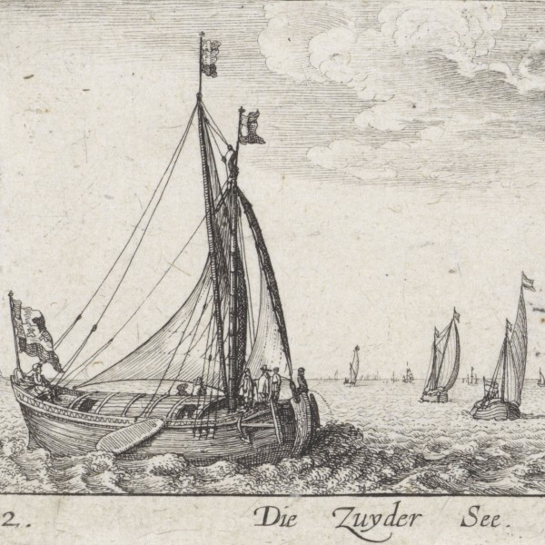
Ship with a leeboard on the Zuiderzee
In paintings and prints from the period, numerous Dutch boats are depicted with leeboards. A leeboard is a flat, vertical board attached to the side of boats without a fixed keel. It can be lowered into the water to prevent a boat from drifting sideways when sailing at an angle to the wind. In the shallow waters along the Dutch coast, a fixed keel might become lodged in the seabed, whereas a leeboard can be raised when not needed.
Stop in Enkhuizen
Samuel Kiechel’s sea voyage to Amsterdam was not proceeding as planned. Strong winds hindered the ship’s progress. After one day and night at sea, sailing against the wind, the crew managed to bring their vessel close to Enkhuizen on the northern coast of the Zuiderzee. Around lunchtime on 28 July, two days after leaving Harlingen, they dropped anchor in the harbour of the town.
Since Kiechel had expected the journey to take only a few hours, he had brought only a small piece of bread aboard. Now, feeling quite hungry, he went into Enkhuizen to find something to eat.
The journeys from Emden to Dokkum and Harlingen to Amsterdam had taught Samuel Kiechel about the unpredictability and dangers of sea voyages. He would learn from these experiences and prepare more carefully when embarking on ships later in his travels.
Regarding Enkhuizen, Kiechel wrote: The city, located in the province of Holland, is large, heavily fortified, and mainly inhabited by fishermen. Many large ships are moored in the harbour, though they are no longer in use.
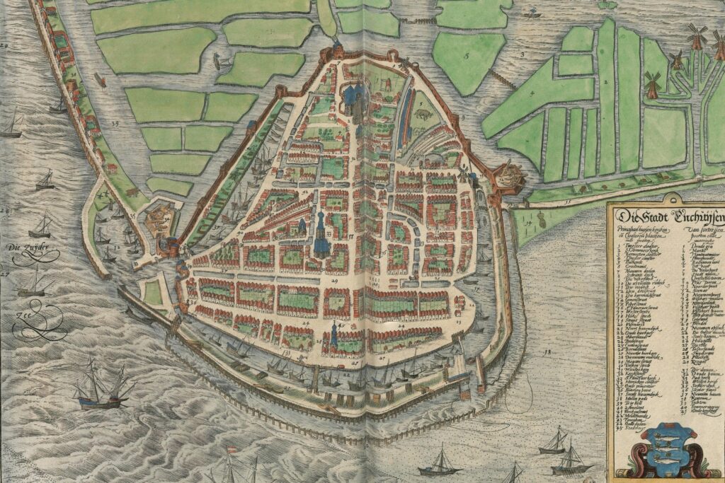
Bird’s-eye view of Enkhuizen, 1581
This detailed bird’s-eye view of Enkhuizen from the east confirms Kiechel’s observations. The city is protected by walls and surrounded by water. Numerous canals around and within Enkhuizen are visible. A large canal runs through the eastern and northern parts of the city, just behind its walls, while another canal crosses its southern section.
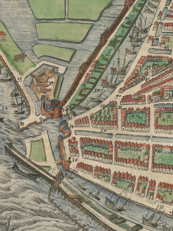
The harbour of Enkhuizen
The view of Enkhuizen features a very elaborate table with eighty-four entries divided into two parts. One part lists the names of various municipal buildings, churches, streets and public squares. The other part includes the names of fortifications, canals and harbour areas. All names are referenced by numbers on the map.
According to these entries, the large canal along the southern part of the city (on the left side of the map) is the new harbour and the shipyard. The section of the canal that runs along the northern side of the city (right side) is the fishery port. Numerous ships are moored along this canal.
Enkhuizen was one of the first Dutch cities to join William the Silent, Prince of Orange, in the revolt against Spanish rule in 1572 (Eighty Years’ War). As a reward, William granted Enkhuizen the Paalkistrecht in 1573. The Paalkistrecht was the right to maintain navigational beacons and buoys in the Zuiderzee and to levy charges from all ships. This privilege was lucrative and served as a powerful tool to control shipping on the Zuiderzee.
Amsterdam had previously held the right to set and maintain the buoyage, but the city remained loyal to the Spanish crown. Consequently, the rebels blockaded the sea routes to Amsterdam across the Zuiderzee. Only when the city joined the rebellion in 1578 did it regain the right to maintain all navigational beacons and buoys in the Zuiderzee.
Due to its role as a transport hub and its location in the centre of the Netherlands, the Zuiderzee served as a focal point in the early struggle of the Dutch against the Kingdom of Spain. The Watergeuzen were Protestant Dutch noblemen fighting against Spanish rule during the early years of the Eighty Years’ War. Their name translates to “Sea Beggars” and originated from a derogatory term used by the Spanish to describe a group of Dutch noblemen who petitioned Margaret of Parma, the governor of the Habsburg Netherlands. One of Margaret’s advisers suggested that the nobles were merely beggars. The Dutch noblemen adopted the term and called themselves Geuzen (Beggars). Because they achieved significant success at sea as privateers, they were widely known as Watergeuzen. In 1573, a Spanish fleet sent to secure the sea routes to Amsterdam was defeated by the smaller Geuzen fleet on the Zuiderzee.
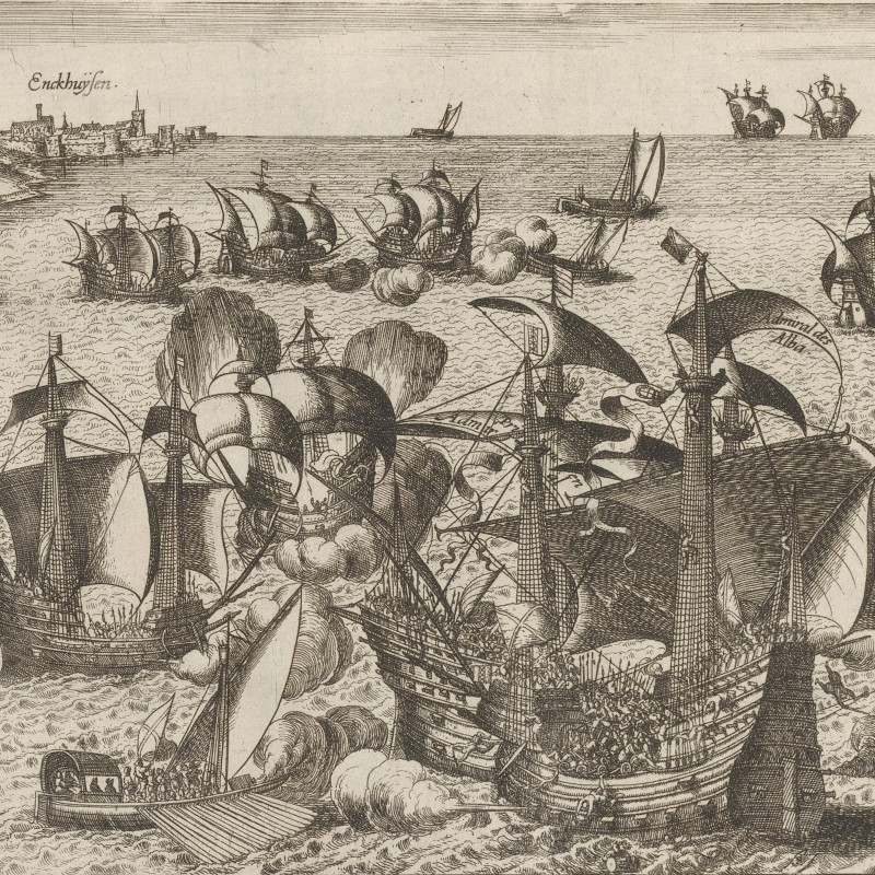
Battle on the Zuiderzee, 1573
Samuel Kiechel spent the day in Enkhuizen. By the afternoon, the wind had calmed, and the ship was ready to depart. Throughout the night, a gentle breeze allowed him to sail to Amsterdam, where he arrived on 29 July.
Illustrations & References
All images are in order of appearance with links to sources on external websites:
- Sorgh, Hendrick Martensz., Storm on the Meuse River, 1668; Rijksmuseum Amsterdam.
- Peeters, Bonaventura, Travellers Disembarking at a Jetty on the Scheldt in Strong Winds, c. 1635; Rijksmuseum Amsterdam.
- Waghenaer, Lucas Jansz., Teerste deel vande Spieghel der zeevaerdt, vande navigatie der Westersche Zee, innehoudende alle de custen van Vranckrijck, Spaignen ende ‘t principaelste deel van Engelandt, in diversche zee caerten begrepen, Leiden 1585, fol 2v; Utrecht University Repository.
- Visscher, Claes Jansz., Vuurbaken te Zandvoort, 1607; Rijksmuseum Amsterdam.
- Hollar, Wenceslaus, Die Zuyder See, 1635; Rijksmuseum Amsterdam.
- Hollar, Wenceslaus, Die Zuyder Zee, 1635: Rijksmuseum Amsterdam.
- Enkhuizen, in: Braun, Georg, Hogenberg, Frans, Civitates Orbis Terrarum (3), Cologne 1593, fol. 30v; Heidelberg University.
- Hogenberg, Frans, Slag op de Zuiderzee, 1573-1583; Rijksmuseum Amsterdam.
- Popta, Yftinus T., Westerdahl, Christer L., Duncan, Brad G., Maritime Culture in the Netherlands: Accessing the Late Medieval Maritime Cultural Landscapes of the North‐eastern Zuiderzee, in: International Journal of Nautical Archaeology Vol. 48/1, 2019. ↩︎
- Ibid. ↩︎
- Waldus, W. B., De Zuiderzee als transportlandschap: Historische maritieme archeologie van de turfvaart (1550-1700), Groningen 2021. https://doi.org/10.33612/diss.174859568 ↩︎
- Ibid. ↩︎
- Ibid. ↩︎
- Ibid. ↩︎