Journal of Samuel Kiechel
25 – 28 June 1585
From Wittenberg to Brandenburg
“… , we left Brexen and travelled to Berlin. The Elector of Brandenburg has his residence in the city. A river flows through Berlin and divides it into two parts with different names. One part of the city, with the palace of the Elector, is called Cölln an der Spree and the other part is called Berlin.“
Die Reisen des Samuel Kiechel aus drei Handschriften, K. D. Haszler (ed.), Stuttgart 1866, pp. 6-7; Bayerische Staatsbibliothek.
From Wittenberg to Berlin
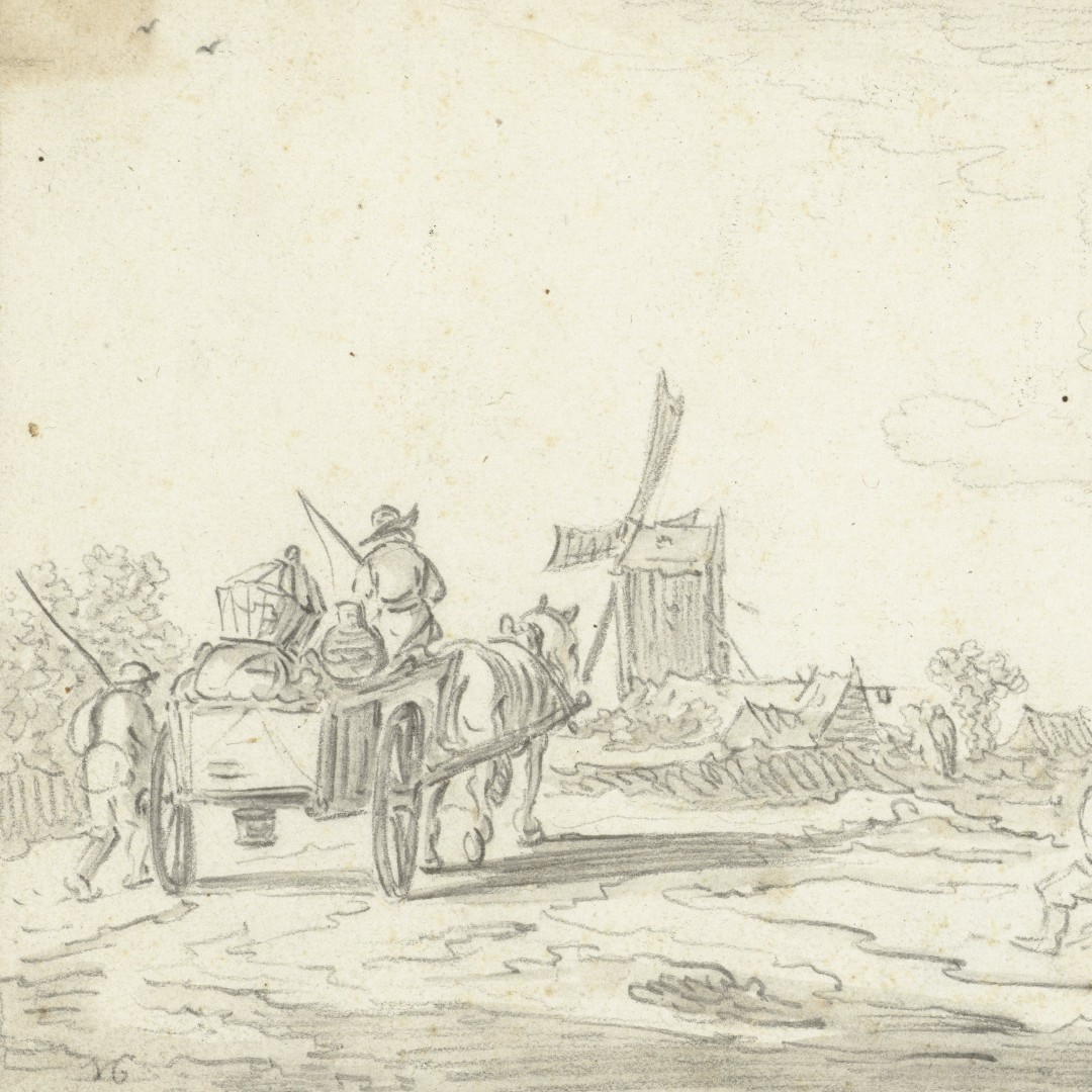
On 25 June, Samuel Kiechel left Wittenberg in the back of a cart headed for Berlin. However, half an hour outside the city, the poor weather had turned the road into a mire. The cart got stuck, and the horses could not pull free. Our traveller had to return to Wittenberg to seek another opportunity to continue. Eventually, he found a Polish coachman from Poznań on his way home. The coachman spoke only Polish, and Kiechel knew only German, French and some Latin.
The language barrier between the traveller and his various companions is a recurring theme of the journey. Kiechel did not primarily choose his companions based on their cultural background or a common language. A general observation about Samuel Kiechel’s journey is that our traveller was fairly open to others and travelled with noblemen and peasants. While he could not ignore the social status of his companions, Kiechel rarely appeared to judge them by it. In the middle of the Empire, he might have eventually found someone who spoke German. However, the Polish coachman was available, and both men agreed to travel together despite barely being able to communicate.
On the way to Berlin, Kiechel and his new companion left the Duchy of Saxony. They stopped in the small town of Treuenbrietzen, located in the Margraviate of Brandenburg. The following morning, they continued their journey and arrived in Berlin that day.

Stopover in Berlin
Berlin, today the largest German city and a popular tourist destination, was not much more than a town on the edge of the Empire in the late sixteenth century. For a traveller from a powerful imperial city in southern Germany, the place must have seemed rather unimpressive. Kiechel wrote: The river Spree divides Berlin into two parts. The Elector of Brandenburg has his court in the city. The part of the city with the palace is called Cölln, and the other part is called Berlin.
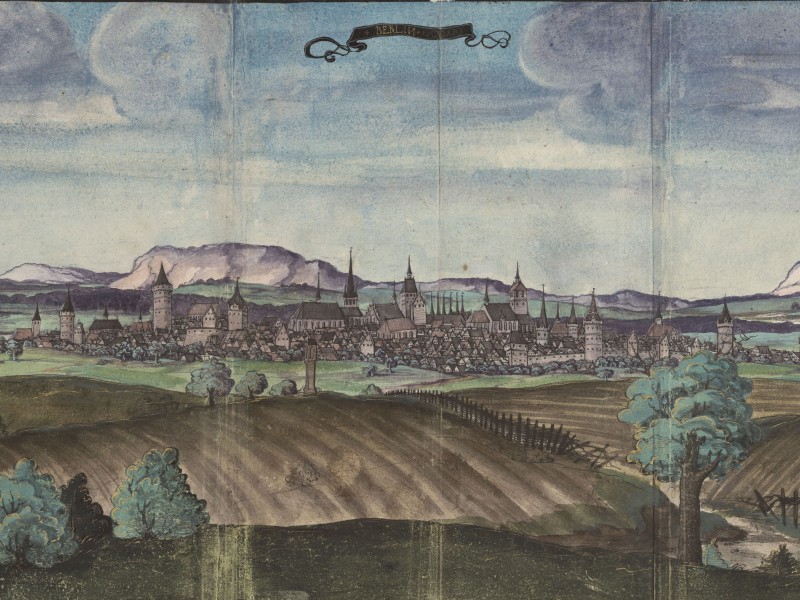
Berlin, 1536
The Civitates Orbis Terrarum contains no image of Berlin. However, a profile view of the city from the northeast appears in Otto-Henry’s journal.1 The view presents a fortified town of moderate size with a few church towers.
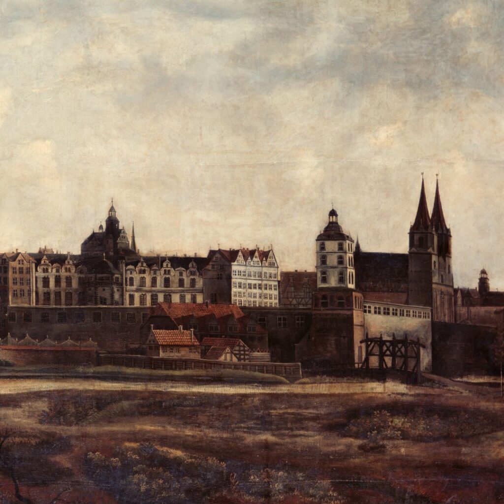
Berlin, c. 1650
Berlin gained importance in the fifteenth century when Frederick I (1371 – 1440) became Elector of Brandenburg. Frederick was from the Hohenzollern Dynasty. Berlin became the political centre of the Margraviate of Brandenburg and the residence of the Elector.
Despite being the residence of the Elector, Berlin was, at the time of Kiechel’s visit, of minor political importance. Power was centred around the Emperor in Prague, and the ruling House of Habsburg had its ancestral lands in the south, in Austria and Switzerland.
Only after the Thirty Years’ War did Berlin become an influential European city. The energetic Elector Frederick William (1620 – 1688) unified his fractured domain and introduced reforms. To restore the country, which had been badly depopulated and devastated, Frederick William issued the Edict of Potsdam (1685). The Edict invited Protestants suffering from religious persecution, especially in France, to resettle in Brandenburg. They were promised land, financial support, tax exemptions, and other benefits. About 20.000 Huguenots accepted this invitation, many of whom were merchants and artisans. The migrants provided a much-needed economic boost after the war’s devastation. When Frederick William’s son, Frederick (Frederick I, 1657–1713), crowned himself King of Prussia in 1701, Berlin became a European capital.
In Spandau
Our traveller left Berlin after only one night and walked to Spandau. While Spandau is now a district of Berlin, it was an independent city until the early twentieth century.
Kiechel faced difficulties finding accommodation. A fair had attracted many merchants and visitors to Spandau, leaving our traveller with no choice but to spend the night ‘on straw’ — likely in a stable.

Spandau and its Citadel, 1652

Spandau Citadel, 1578
In Spandau, Kiechel saw a stunning fortress at the confluence of the rivers Spree and Havel — Spandau Citadel. Joachim II (1505-1571), Elector of Brandenburg, ordered its construction in 1559, and work on the fortress was completed in 1594. However, the first soldiers moved there in 1580. Today, the Citadel is regarded as one of the best-preserved fortifications from the Renaissance era.
Samuel Kiechel departed from Spandau on the morning of 28 June, accompanied by a carter. The carter had a small vehicle pulled by a single horse. Our traveller noted the peculiar transport typical of this region: Due to the quality of the roads and the flat landscape, people use wheelbarrows to transport salt, grain and other goods to and from various locations.

The two men arrived in Brandenburg in the evening, a large and old city. According to Kiechel, the Havel River flowed through it, dividing the Old and New Towns.
Brandenburg is about sixty kilometres west of Berlin. It was an important city in the Middle Ages, serving as the seat of a diocese. The March of Brandenburg and later the Margraviate of Brandenburg took their name from the city. However, the secularisation of the diocese at the end of the sixteenth century, combined with the city’s proximity to Berlin, the new residence of the Electors of Brandenburg, led to a decline in its importance. The destruction caused by the Thirty Years’ War (1618–1648) further diminished Brandenburg’s status, leaving it a minor provincial city.
Illustrations & References
All images are in order of first appearance with links to sources on external websites:
- Berlin, in: Reisealbum des Pfalzgrafen Ottoheinrich 1536/37; Wikimedia Commons.
- Anonymous, Landschap met boerenkar, 1606 – 1700; Rijksmuseum Amsterdam.
- Ruyscher, Jan, Ansicht Berlins von Nordwesten (Berlin from the northwest), 1650-1660; Stiftung Preußische Schlösser und Gärten Berlin-Brandenburg.
- Spandau Citadel, in: Zeiller, Martin, Topographia Electorat[us] Brandenburgici et Ducatus Pomeraniae, 1652; Bayerische Staatsbibliothek.
- Biller, Thomas, “Lynarplan” und die Entstehung der Zitadelle Spandau im sechzehnten Jahrhundert. Berlin, 1981; Universität Heidelberg.
- van de Velde, Jan, Landschap met een toren en een brug over rivier de Niers, 1616; Rijksmuseum Amsterdam.
- Pabel, Angelika, Pleticha-Geuder, Eva, Schmid, Anne, Schmidt, Hans-Günther (eds.): Reise, Rast und Augenblick. Mitteleuropäische Stadtansichten aus dem 16. Jahrhundert, Ausstellungsführer, Dettelbach 2002, p. 92f. ↩︎