
Journal of Samuel Kiechel
1 – 5 May 1586
In Rostock
“The city has a university, and a few young noblemen who are students there frequently visited the inn where I stayed at mealtimes. One day, other noblemen came to visit them. Together, they spent an entertaining two days eating, drinking and dancing.“
Die Reisen des Samuel Kiechel aus drei Handschriften, K. D. Haszler (ed.), Stuttgart 1866, p. 90; Bayerische Staatsbibliothek.
To the Gates
Samuel Kiechel had left Denmark by ship bound for Wismar on the German coast. After a turbulent eight days at sea, with adverse winds and a heavy storm, he ran out of provisions and decided to return to land. He walked to Gedser on the island of Falster, from where it was just a day’s sailing to Warnemünde. He arrived long after nightfall on 30 April 1586 and spent the rest of the night there.
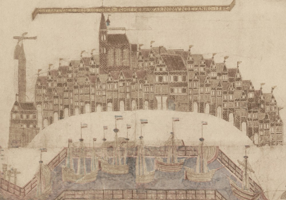
Warnemünde, 1582
Warnemünde was a fishing village at the mouth of the Warnow River, near the city of Rostock. Kiechel wrote that local fishermen went out at night in their boats and, when they returned early the next morning, sailed up the Warnow to Rostock to sell their catch. Kiechel got up early and found a fisherman who took him on his boat to the city. They arrived at the gates of Rostock an hour before they opened.
Once he was able to enter the city, Kiechel headed to the market square and took accommodation at the inn of Niclas Bergmann. According to our traveller, Rostock was a port city, large but not heavily fortified. It lay in the land of Mecklenburg and was under the protection of the Duke of Mecklenburg. Samuel also noted that very good beer was brewed in the city.1
Rostock in the Sixteenth Century
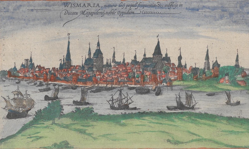
Rostock, 1572 (the prints of Wismar and Rostock were mixed up and have the wrong names)
The Civitates Orbis Terrarum contains two views of Rostock. Both depict the city in profile from the east, with the Warnow River in the foreground. The first appears in volume one of the Civitates, first published in 1572. It is on a page with three other images. The view is mistakenly titled Wismaria (Wismar), the city Kiechel was actually travelling to when he left Copenhagen before the weather forced him to change plans. The engravers of the plates for Rostock and Wismar presumably mixed up the images.
The view shows Rostock as a large port city with many church towers. The river and harbour are busy with ships of various sizes. Compared with the second image, published in volume five in 1598, the first lacks detail and appears to be a copy of an older woodcut. While Rostock’s silhouette is clearly recognisable, it looks rather generic. The second view contains much more detail, from the names of various buildings to the distinct shapes of the town hall (Curia) and St. Mary’s Church (D. Mariae) to the busy quayside with people and cargo.
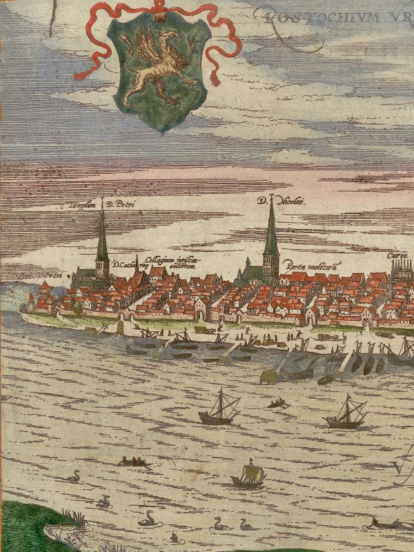
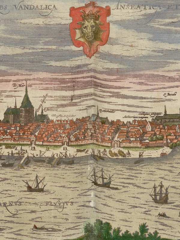
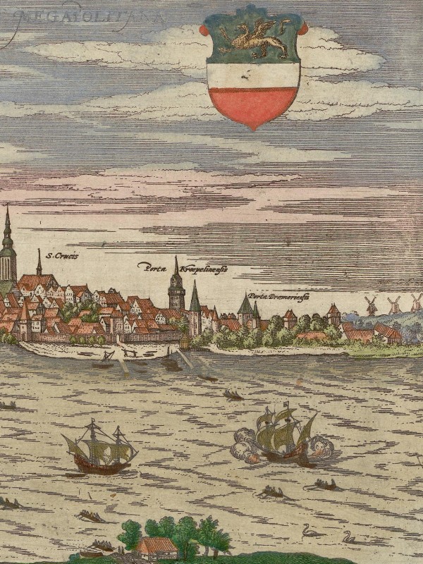
Rostock, 1598
During Samuel Kiechel’s visit to Rostock, the city was experiencing rapid economic growth after a period of decline and political turbulence.
Compared with other cities along the Baltic Sea coast, where the Protestant Reformation had already taken hold in the 1520s, Rostock adopted it only in 1531, after resistance from the city council and the university. In addition, a conflict was brewing in Rostock between the council’s magistrates and the general population. Over time, it had become a rule to allow only members of Rostock’s patrician families to serve on the council. Everyone else was excluded. As a result, the majority of Rostock’s population had no representatives to speak on their behalf. They demanded that a second chamber be established, particularly to give craftsmen and artisans a voice.2
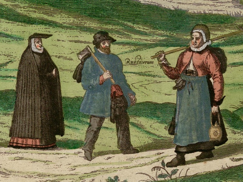
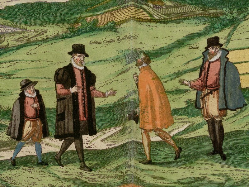
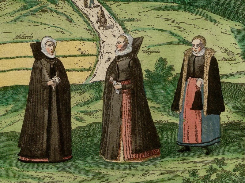
The second view in the Civitates Orbis Terrarum includes costume prints of Rostock’s inhabitants. The first image shows peasants, the second shows a council member and two citizens, and the third shows three women.
Rostock’s territorial lord, Johann Albrecht I (1525-1576), Duke of Mecklenburg, became involved in the growing conflict on the side of the old city council and eventually occupied the city in 1565. Attempts by the populace to establish a second representative body to counter patrician influence were thwarted. The Duke ordered the city walls to be torn down to prevent resistance.3 Samuel Kiechel noted that the city was not heavily fortified.
In two subsequent treaties in 1573 and 1584, Rostock came under the Duke’s full control. The struggle for autonomy was typical of German cities in the late medieval and early modern periods. Some cities, like Ulm, Hamburg and Regensburg, managed to maintain their freedom, while others, like Rostock, lost their autonomy and became subjects of their territorial lord. However, with the loss of autonomy, tensions within the city eased, laying the foundation for Rostock’s second economic boom.4
Samuel Kiechel noted that high-quality beer was produced in Rostock. Beer was a key product in the city’s economy in the late sixteenth century. The right to brew beer and trade in the necessary ingredients (barley, hops and malt) was strictly regulated. A seventeenth-century property register lists about 250 houses where beer was brewed.5 Many of those houses were private residences rather than commercial breweries. Beer brewing was therefore not confined to a specific part of Rostock, unlike other trades, but was found throughout the city.6 In private residences, beer was produced for daily consumption and also exported. The beer trade was lucrative, and professional brewers were among the city’s wealthy elite.7
Like Walking Through Rostock — The Vicke-Schorler-Rolle
About two months after Samuel Kiechel arrived in Rostock, on 24 June 1586, a young local grocer completed a project he had begun eight years earlier. The man’s name was Vicke Schorler, and he had produced a fascinating view of Rostock. The so-called Vicke-Schorler-Rolle, or Warhaftige Abcontrafactur der Hochloblichen und Weitberumten Alten See- und Hansestadt Rostock (Truthful Depiction of the Praiseworthy and Famous Old Maritime and Hanseatic City of Rostock), is a unique eighteen-metre-long, sixty-centimetre-high pen-and-watercolour drawing of the city and its surroundings. It consists of 127 sheets of paper glued together.8
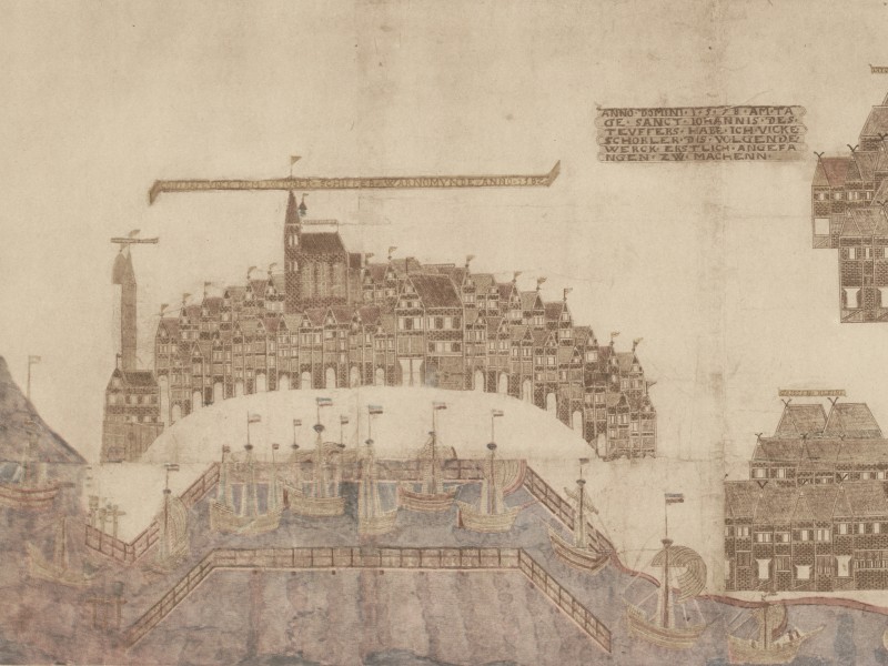
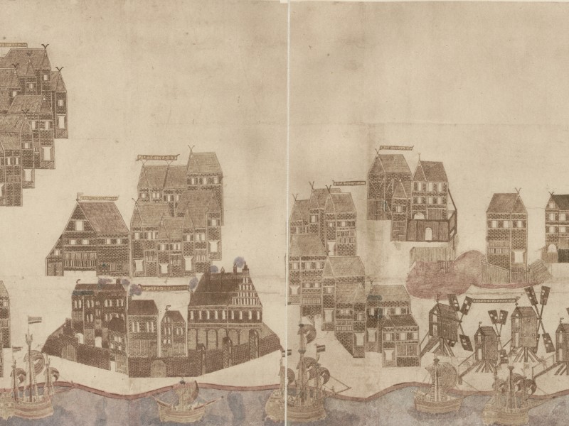
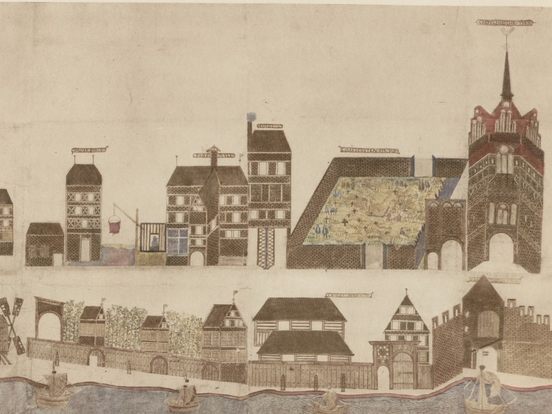
The Schorler-Rolle from Warnemünde on the left to Rostock on the right. Samuel Kiechel sailed along this stretch of the Warnow. The tower on the right edge is the Kröpeliner Tor; it still stands today. But arriving by boat, Kiechel most likely entered the city through one of the many gates along the river.
Schorler began this project in 1578, when he was still a teenager. He was not a professional artist, and compared with the views in the Civitates Orbis Terrarum, his work looks somewhat naive. Yet the level of detail is astonishing, particularly given that Vicke Schorler did it without formal training.
The Schorler-Rolle is divided into three parts. It starts on the left with the area north of the city, from Warnemünde along the Warnow River to Rostock. It is followed by the central part of the image, which shows Rostock. At fourteen metres, this is the largest part. The third part shows villages to the south, up to the towns of Güstrow and Bützow. The view is not drawn to scale, and the central part is shown much larger than the surrounding area.
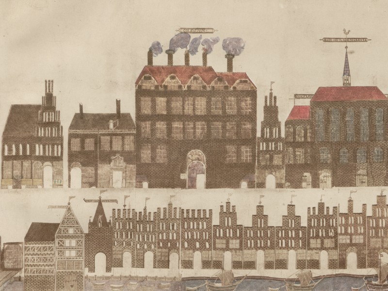
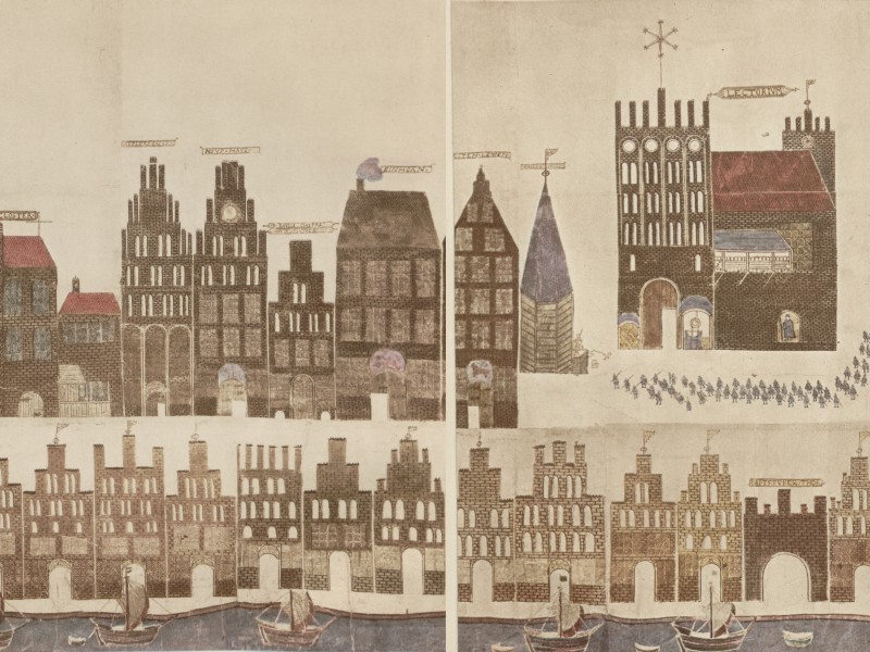
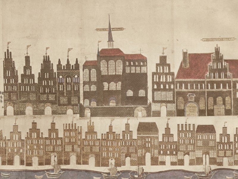
Rostock’s Hopfenmarkt with the Philosophical College (COLEGIVM), the Regentien houses and the Auditorium Magnum (LECTORIVM) with a procession of students.
Throughout the view, the Warnow River runs along the bottom of the image, connecting all three parts.9 Because the Schorler-Rolle starts with Warnemünde on the left and places the Warnow at the bottom, it is a mirror view of the area. Both Warnemünde and Rostock are on the western bank of the river, whereas the Rolle presents them on the eastern side.
One reason for the differences in size among the three parts is the way Schorler depicted Rostock in relation to its surroundings. Places north and south of the city are shown in bird’s-eye view. Schorler did not draw the landscape, only the towns and villages, such as Warnemünde. The area around Rostock therefore appears as a collection of settlements, with the Warnow River as the only connecting feature.10
In comparison, Rostock is depicted as two rows of houses, as if walking along a street. The houses in the upper row are drawn larger and contain the most notable buildings in the city. The level of detail in the buildings’ facades, gables, and brickwork shows Schorler’s effort and attention to detail. Despite the appearance of a single street, the Schorler-Rolle is more like a walking tour through Rostock, connecting multiple streets and passing by the most notable buildings. Apart from the buildings and the Warnow River with many ships and boats, there are very few additional details, such as scenes of street life.11
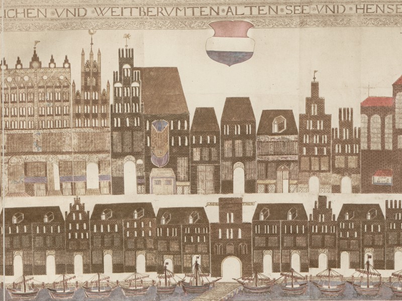
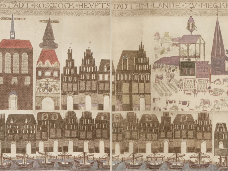
The Mittelmarkt of Rostock
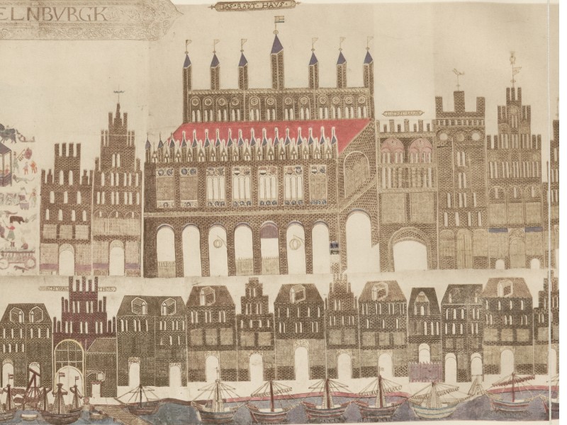
This segment of the Schorler-Rolle shows the Mittelmarkt (today called Neuer Markt) of Rostock. Because Vicke Schorler focused almost exclusively on house facades and followed them to produce a long, continuous street view, he did not present the market as a whole. Entering from the west, he followed the houses along the southern side of the Mittelmarkt, then left it via Steinstraße towards the Steintor, Rostock’s southern gate. Schorler then returned to the market to depict its eastern side with the town hall and then went north again to St. Mary’s Church. As a result, any sense of this being a market square is lost. Possibly as a token of the place’s character, the artist included one of the very few scenes of local life. We see the Mittelmarkt on market day, with vendors having spread out their merchandise.
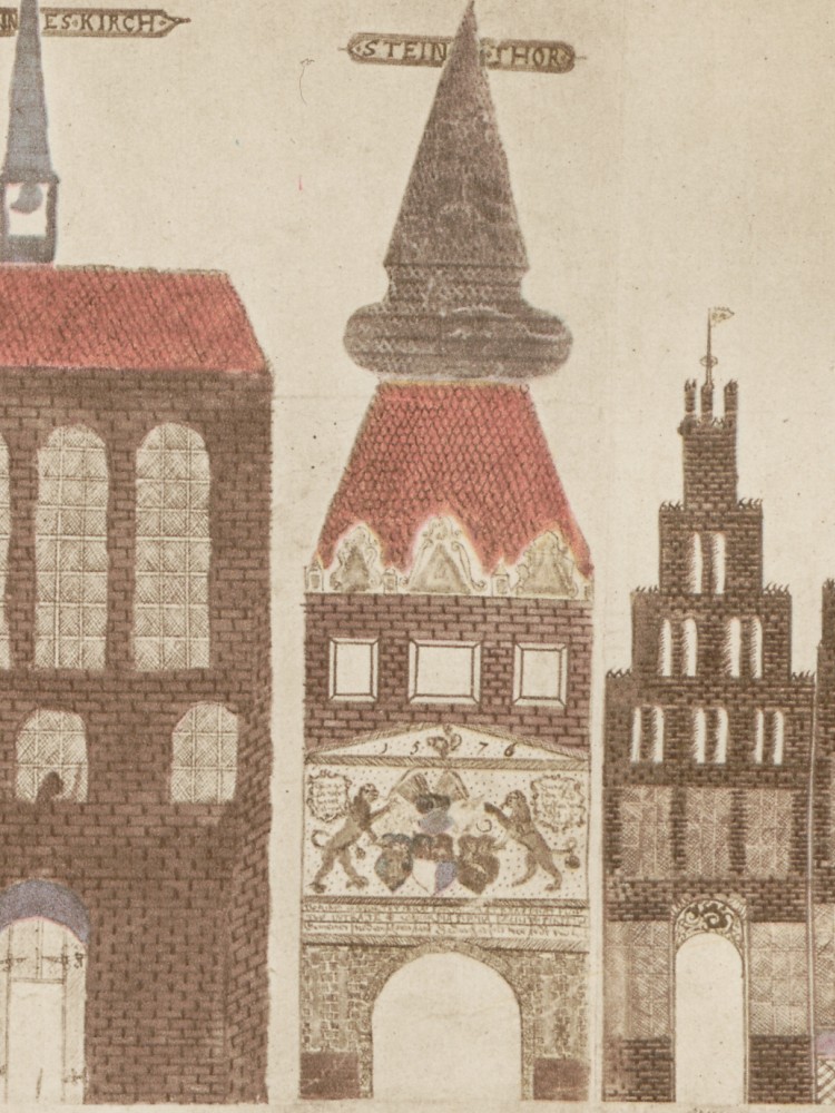
The Steintor, Rostock’s southern gate. Construction had finished only a few years earlier, in 1576. The gate still stands today.
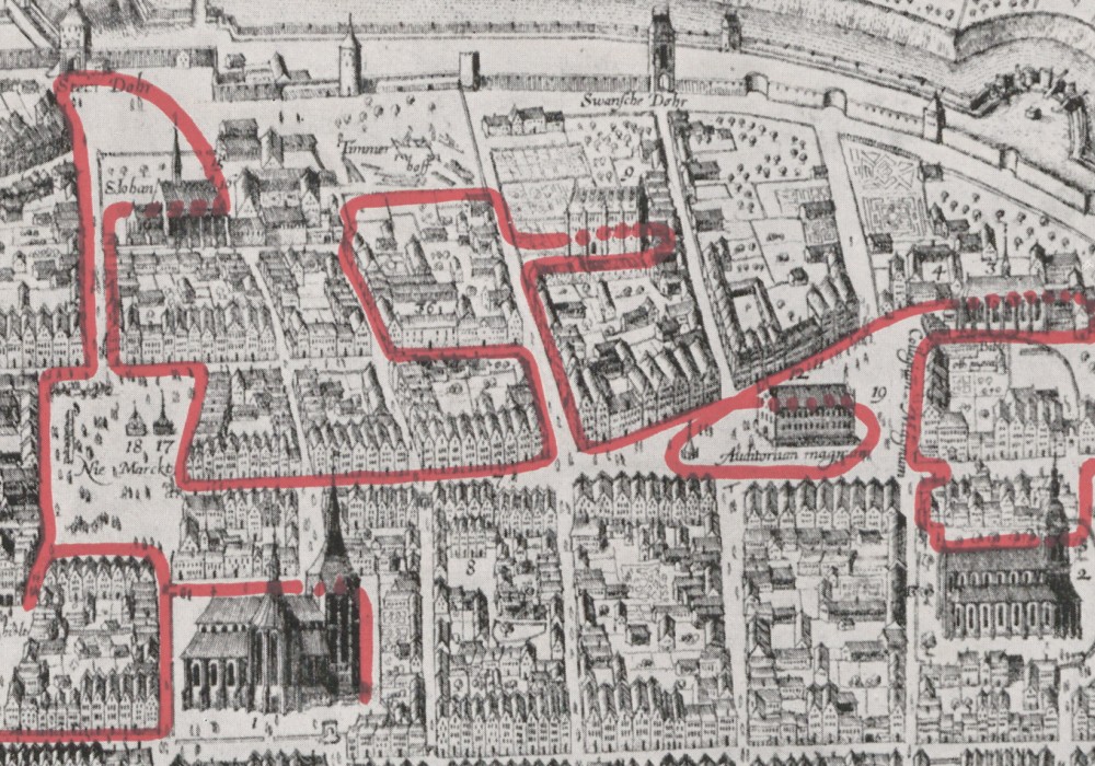
The reconstructed route Vicke Schorler followed from the Hopfenmarkt (Hops Market) on the left to the Mittelmarkt (Middle Market) on the right, as shown on a 1625 map.12 The map is oriented to the west. Following the Schorler-Rolle from left to right, the artist entered from the north (right side), circled the Hopfenmarkt, made a detour west (up) to the Michaelis monastery, then continued to the Mittelmarkt (left side of the map). He left the Mittelmarkt heading west (up), including the Steintor, then returned to the market square and continued north-east to St. Mary’s Church (bottom left).
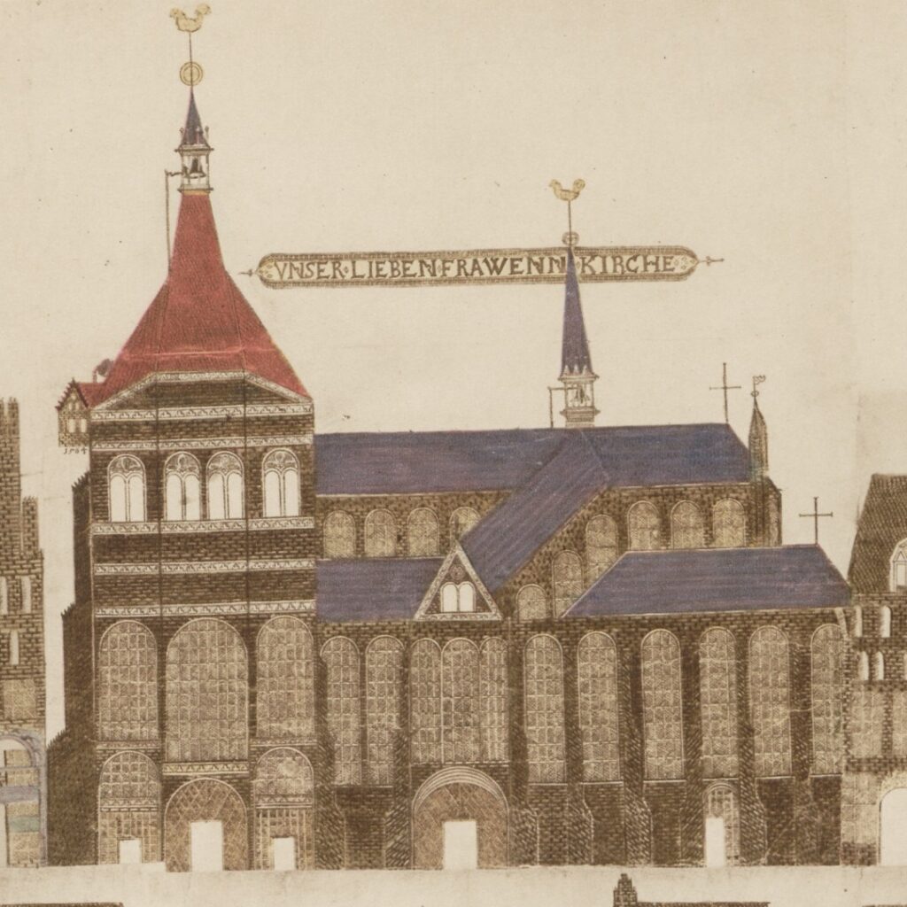
An architectural feature showcased throughout the Schorler-Rolle is the use of bricks in the construction of most buildings. Due to the lack of natural stone, many towns and cities along the southern Baltic Sea coast used fired clay bricks to build churches, fortifications, gates, warehouses and private houses. The architectural style, known as Brick Gothic, was used in the region during the late Middle Ages. Impressive examples of this style include St. Mary’s Churches in Rostock and Lübeck, as well as St. Mary’s in Gdańsk, Europe’s largest brick church.13
St. Mary’s Church in Rostock
Vicke Schorler included only a few scenes of street life. In part, this was likely due to the nature of the project. Schorler most likely drew each of the 127 sheets for the Rolle individually before glueing them together. As a result, despite resembling a street view, the houses seem oddly disconnected and sterile, and the streets are devoid of life. In addition, despite the title’s claim to be a truthful depiction of the city, there are no signs of ramshackle buildings or lower-quality housing, as would usually be found in such a large city.
Nevertheless, while many artists of the time drew city views as lifelike as possible (see Civitates Orbis Terrarum), the Schorler-Rolle presents a stark but fascinating contrast. A facsimile of the map, annotated with explanatory notes on the houses depicted, is in the appendix of a book freely accessible on the University of Rostock’s website. A copy of the whole Schorler-Rolle is also on Wikipedia.
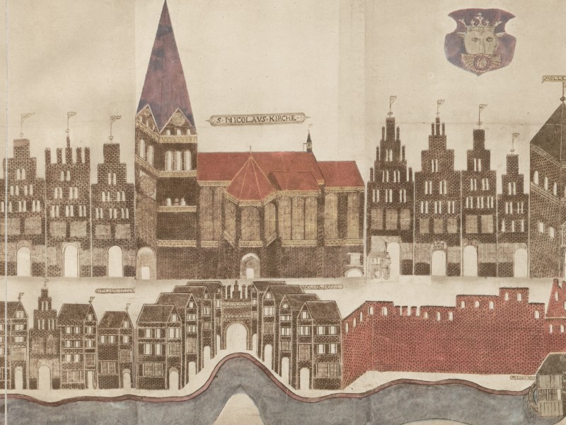

Southern side of Rostock with St. Nicolas Church and the Mühlentor (Mill Gate). In another rare depiction of local life, we see various carts arriving at the gate.
Samuel Kiechel in Rostock
Samuel Kiechel wrote that Rostock has a university, and that some of the noblemen who studied there had their meals at the inn where Kiechel stayed. During his time in the city, other noblemen visited the house to see the students, and together with our traveller, they enjoyed two entertaining days of eating, drinking, dancing and other activities.14
This comment concludes with Kiechel referring to a letter he wrote. It is the only point in the journal where he mentions writing letters home. While the revelation that Samuel communicated his experiences to his family in Ulm should not surprise us, it seems odd that there are no other references to it. We do not know how many letters he wrote or how often, and none of them has survived.
In the journal, Kiechel continues that one morning some of the university’s professors were outside the inn in the market square. When the noblemen in Kiechel’s accommodation saw them, they grabbed some of the innkeeper’s books and threw them out the window into the street. Kiechel assumed they did this to honour the professors, a somewhat strange conclusion.
As usual, Samuel Kiechel wrote little about his stay in Rostock. I went to the city’s archive hoping to find additional information. Unfortunately, neither the name of Kiechel’s innkeeper, Niclas Bergman, nor the inn itself was mentioned in the sources I consulted.
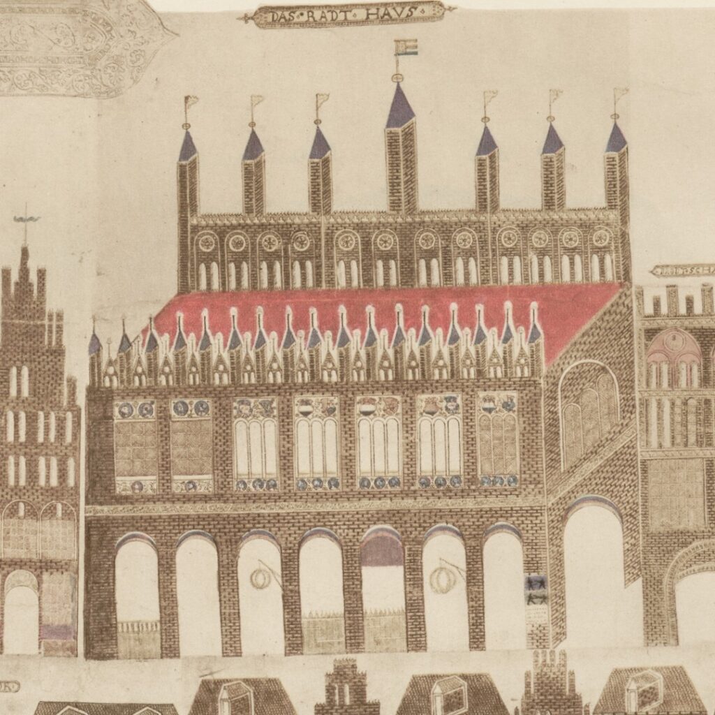
The town hall of Rostock on the Mittelmarkt
Regarding the inn’s location, Kiechel wrote that it was at the market. In the late sixteenth century, Rostock had several market squares. The Mittelmarkt (Middle Market; today called Neuer Markt/New Market) and the Hopfenmarkt (Hops Market; today called University Square) were the two largest and most important. On the Mittelmarkt stood the town hall, the city’s wine cellar and the houses of many influential citizens. At the Hopfenmarkt were various university buildings.
The University of Rostock was founded in 1419 and is one of the oldest in Germany. The Auditorium Magnum (large lecture hall) stood in the centre of the Hopfenmarkt. The Philosophical College, the houses of several professors and five houses with accommodation for students and rooms for teaching (called Regentien) were around the square. These Regentien houses were essentially student dormitories, and each had a name. They were called: Porta Coeli (Heaven’s Gate), Roter Löwe (Red Lion), Einhorn (Unicorn), Halbmond (Half Moon) and Adlerburg (Eagle’s Castle).15 According to the “Regentienordnung” (Regulation of the Student’s houses) of 1569, each house was overseen by graduates who had to offer lectures in writing and disputation. Two professors in turn oversaw them.16
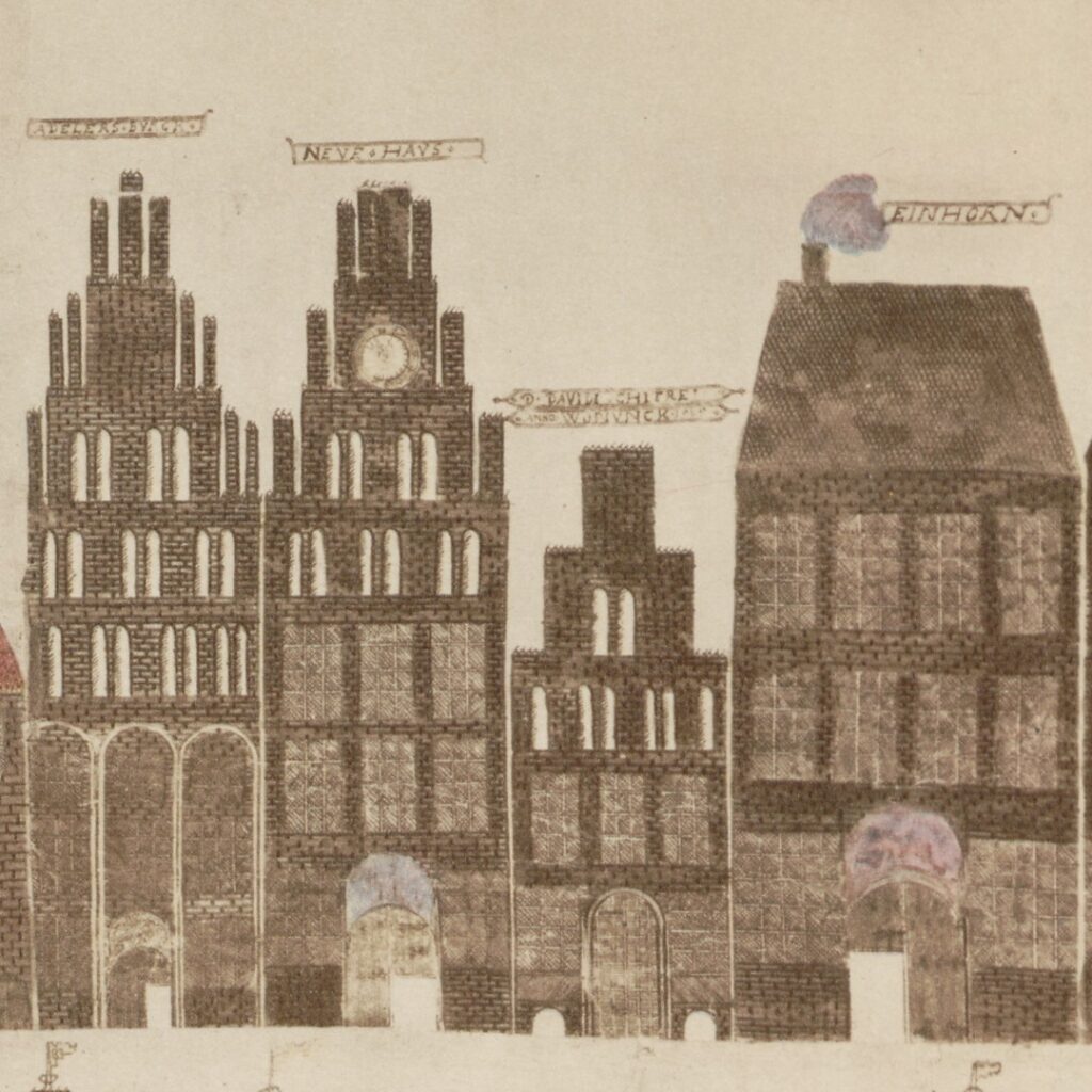
Two of Rostock’s five Regentien houses: the Eagle’s Castle (Adelers Burck) on the left and the Unicorn (Einhorn) on the right.
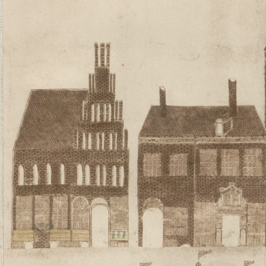
Two houses on the Hopfenmarkt. Maybe one of them was the inn where Samuel Kiechel stayed?
The inn where Samuel Kiechel stayed and where students from noble families went for lunch could have been at either the Mittelmarkt or the Hopfenmarkt. A property register of Rostock compiled fifteen years after Kiechel’s visit contains no mention of an inn at any of Rostock’s markets.17 But that does not mean such an establishment did not exist in 1586. It could have closed in the meantime, or it may not have been an official inn but rather private accommodation. Proximity to the university suggests the inn was located at the Hopfenmarkt. However, the Mittelmarkt was where wealthier citizens lived, and noble visitors usually stayed.18
Having young noblemen study at a university was no longer unusual in the sixteenth century. The time when influential positions in the Holy Roman Empire and the Church depended solely on being born into the right families was past. Education became a key requirement, and the wealthy citizenry became serious competition. As a consequence, more and more young noblemen were sent to universities in the Empire and across Europe. According to the Matriculation Register of Rostock University from 1585, nine young noblemen were studying in the city and may have been Kiechel’s acquaintances. Three of them were from the province of Mecklenburg, two from Pomerania, three from Schleswig and Holstein and one from Brandenburg.19
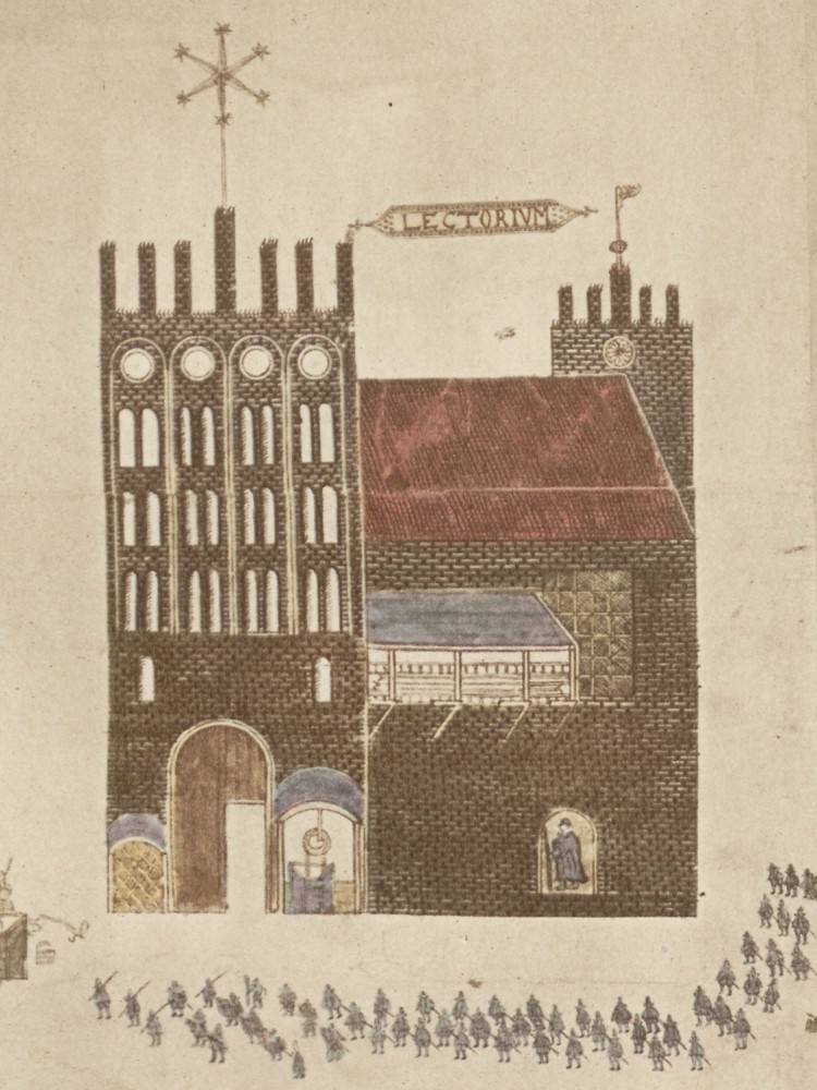
The Auditorium Magnum stood in the middle of the Hopfenmarkt. As one of the few glimpses of city life, Vicke Schorler depicted a procession of students in front of the building.
While life in the Regentien-houses had been strictly regulated, the growing number of noble students meant that regulations were relaxed. Wealthy students increasingly stayed in private accommodation, and students’ lives grew closer to what we might consider today.20 Samuel Kiechel wrote that he spent a few relaxed days with students, eating, drinking and dancing. As for the students throwing books out of the inn’s windows when they spotted their professors in the market square, I doubt Kiechel’s explanation that this was done to honour the professors.
Our traveller spent five days in Rostock to recuperate from his previous endeavours. He left the city in a coach on 5 May 1586, heading east along the Baltic Sea.
Illustrations & References
All images are in order of appearance with links to sources on external websites:
- Rostock, in: Braun, Georg, Hogenberg Frans: Civitates Orbis Terrarum (1), Cologne 1593, fol. 27v; Heidelberg University.
- Rostock, in: Braun, Georg, Hogenberg Frans: Civitates Orbis Terrarum (5), Cologne 1599, fol. 47v; Heidelberg University.
- Vicke Schorler, Warhaftige Abcontrafactur der hochloblichen und weitberumten alten See- und Hensestadt Rostock, Heubtstadt im Lande zu Mecklenburg 1578 – 1586, Rostock 1939; Rostock University.
- Die Reisen des Samuel Kiechel aus drei Handschriften, K. D. Haszler (ed.), Stuttgart 1866, p. 90; Bayerische Staatsbibliothek. ↩︎
- Münch, Ernst, Zwischen Reformation und Dreißigjährigem Krieg. 1523 bis 1648, in: Schröder, Karsten (ed.), In deinen Mauern herrsche Eintracht und allgemeines Wohlergehen. Eine Geschichte der Stadt Rostock von ihren Ursprüngen bis zum Jahre 1990, Rostock 2003, pp. 53-92, see pp. 53f. ↩︎
- Ibid., pp. 56-61. ↩︎
- Ibid., pp. 68f. ↩︎
- Münch, Ernst, Die Brauherren. Rostocks führende Schicht im Ausgang des 16. Jahrhunderts, in: Pelc, Ortwin (ed.), 777 Jahre Rostock. Neue Beiträge zur Stadtgeschichte, Rostock 1995, pp. 95-102, see p. 95; Münch, Zwischen Reformation und Dreißigjährigem Krieg, pp. 81f. ↩︎
- Münch, Die Brauherren, pp. 96f. ↩︎
- Münch, Zwischen Reformation und Dreißigjährigem Krieg, pp. 68f. ↩︎
- Gehrig, Oscar, Vicke Schorlers wahrhaftige “Abcontrafactur” der See- und Hansestadt Rostock, in: Vicke Schorler, Warhaftige Abcontrafactur der hochloblichen und weitberumten alten See- und Hensestadt Rostock, Heubtstadt im Lande zu Mecklenburg 1578 – 1586, Rostock 1939, p. 17; Rostock University. ↩︎
- Ibid., pp. 19-26. ↩︎
- Ibid. ↩︎
- Ibid. ↩︎
- Gehrig, Vicke Schorler’s wahrhaftige “Abcontrafactur“, p. 23. ↩︎
- Following the traces of the Middle Ages and the Hanseatic League, 2020, European Route of Brick Gothic. ↩︎
- Reisen des Samuel Kiechel, pp. 90f. ↩︎
- Asche, Matthias, Von der reichen hansischen Bürgeruniversität zur armen mecklenburgischen Landeshochschule. Das regionale und soziale Besucherprofil der Universitäten Rostock und Bützow in der frühen Neuzeit (1500 – 1800), 2. ed., 2010, pp. 380-382; Münch, Zwischen Reformation und Dreißigjährigem Krieg, pp. 63f. ↩︎
- Asche, Von der reichen hansischen Bürgeruniversität, p. 59. ↩︎
- Münch, Ernst (ed.), Das Rostocker Grundregister (1600-1820), Rostock 1998. ↩︎
- Münch, Zwischen Reformation und Dreißigjährigem Krieg, p. 81. ↩︎
- Asche, Von der reichen hansischen Bürgeruniversität, Appendix, tab. 16, p. 572 and tab. 17, p. 576 ↩︎
- Ibid., p. 384. ↩︎