„In the contemporary world, with its seemingly limitless capacities for producing, reproducing and transmitting graphic images, the map is a ubiquitous feature of daily life: the route map at the bus stop or subway station, the weather map on television, the location map in the travel brochure, the iconic map of the commercial advertisement. Maps are thus intensely familiar, naturalized, but not natural, objects working within a modern society of high if uneven cartographic literacy.”1
Maps in the Sixteenth Century
As the quote above states, maps are a key element of modern life, whether in traditional paper form or as digitalised versions on electronic devices. Yet using maps doesn’t come naturally to us, even if it may appear to. It requires a level of education, including the ability to read, write and engage in abstract thinking, to translate the physical world around us into the two-dimensional format of a map.
If we look at today’s multitude of purpose-made local and regional maps, such as street maps, weather maps, trail maps, real estate maps, location maps and more, there is nothing comparable from the sixteenth century. Maps played a relatively minor role in everyday practical life. We know of surveys and local maps made to help resolve legal disputes over boundaries. There are also naval charts, such as those made and published by Lucas Jansz. Waghenaer. But that’s about it. Travellers like Samuel Kiechel did not mention using maps at all.
Nevertheless, maps were popular, and cartography made enormous progress at the time. The first modern atlas, Abraham Ortelius’ Theatrum Orbis Terrarum, was published in the 1570s and reprinted in subsequent editions. As good and quite accurate as the maps in this atlas are, their practical use was very limited. Most maps did not even show major roads. Even planning a journey with them was difficult because the maps were not connected. They were drawn by different artists and focused on specific regions or territories. There was no uniform scale across all maps, and information about neighbouring territories was rarely provided. The maps were organised by country, but there was no further apparent order.
Access to the Theatrum and other atlases was limited to the educated, to people who had the time and money to engage in the pastime of learning about the world via maps. Just like Georg Braun and Frans Hogenberg, Abraham Ortelius considered his atlas a substitute for travelling. The idea was to learn about places in the world from the comfort of home, not to inspire a longing to visit them. So, due to the limited means of communication and media and the still fairly low level of education among the people, the sixteenth century was a time of very unevenly spread cartographic literacy.
Samuel Kiechel was not a student or scholar, but he had received an education and, as the journal shows, was curious about the world around him. Maybe he had used maps to choose destinations for his journey before he left. Maybe he read about Stockholm or Danzig and even saw prints of them in the Civitates Orbis Terrarum (he does not mention it), but there is a difference between reading or hearing about a place and finding your way there.
This raises the question of how Kiechel perceived the world around him and how he determined a destination’s location relative to his position. Did he know the direction home in case of an emergency? We have to keep in mind that road signs were rare, and while there were itineraries for planning routes, they had severe limitations.
So, while Samuel Kiechel still enjoys his time in Danzig, I would like to write about an aspect of his journey I have alluded to previously: orientation and the perception of geographic space in the sixteenth century.
Making a Map — Caspar Henneberger’s Prussiae Map
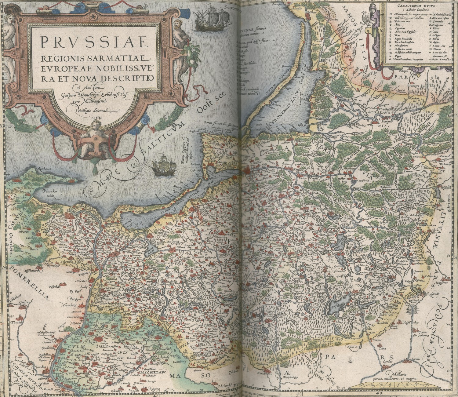
Caspar Henneberger’s Prussiae Map in the 1587 edition of Theatrum Orbis Terrarum
To help with this aspect, I would like to introduce Caspar Henneberger. Henneberger (1529-1600) was a contemporary of our traveller; he was a Protestant theologian who served as a pastor in the village of Mühlhausen in Prussia, not far from Danzig. He also produced two maps of Prussia. The first was published in 1576, and the second, a revised version, in 1595. Both maps depict the Duchy of Prussia, the regions of Warmia and Chełmno and the area around Danzig.2
Caspar Henneberger was neither an artist nor a professional mapmaker. As far as we know, he was a self-taught cartographer. According to his own account, Henneberger developed an interest in cartography while studying theology in Königsberg (Kaliningrad). He began collecting maps of Prussia and comparing them with what he knew about the land, what he had read, and what he had heard from reliable sources.3
In addition to his maps, Henneberger published a book to explain them to his readers (Ercleru[n]g der Preüssischen grössern Landtaffel oder Mappen).4 This was not unusual. As we have seen, the Swedish cartographer Olaus Magnus did so. Like Magnus, Henneberger collected information about towns, cities, castles and other notable places. He arranged them alphabetically for ease of use. At the end of the book, he added a section listing all the rivers and lakes of Prussia.
However, Henneberger went further. He explained his motivation and approach and described the problems and frustrations he encountered. Those comments were unusual for their time and offer us a glimpse into the difficulties of making a map, as well as into how people perceived geographic spaces when maps were not part of everyday life, when geography was not part of education, and when many people could still not read or write and had never seen a map.
Caspar Henneberger set out to make his map because he found existing depictions of Prussia underwhelming. In particular, he pointed to the map in the first edition of Abraham Ortelius’s wildly popular atlas.5 This map was made by Heinrich Zell, who, unlike Henneberger, was a cartographer and astronomer.
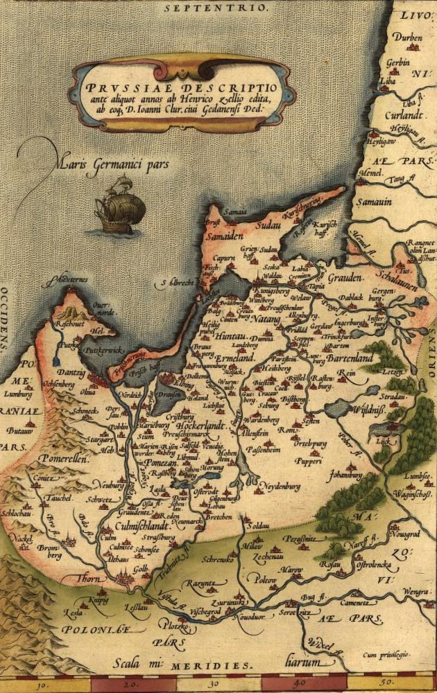
Heinrich Zell’s map of Prussia in the first edition of Theatrum Orbis Terrarum, 1570
But this did not deter Henneberger. He had a clear idea of his map’s purpose. He wanted to present Prussia as a whole, allowing the observer to see all its places, including cities and towns, castles, forests and rivers, and to show how much the Lord had blessed this land. In short, Henneberger was making a representational map for those educated enough to study and enjoy it.6
He even dedicated a section of his book to advising readers how to use the map. As mentioned, he ordered the places in his book alphabetically and added a letter and a number to each place. This was a simple set of coordinates. Along the two vertical edges of his map, he placed letters, and the numbers were along the horizontal edges. Henneberger advised his reader to use two pieces of string to connect the appropriate letter mentioned for a specific place, and to do the same with the number. Where the two pieces of string intersected, the reader would find the place mentioned in the book.7 The whole system is similar to modern city plans.
One person who was supposed to enjoy the finished map was Duke Albrecht Friedrich of Prussia. He supported Henneberger’s project financially and even directed people in the districts of Prussia to help by providing information on the lay of the land and geographical features, such as rivers and borders.8
Caspar Henneberger set out to make his map and, between 1570 and 1576, undertook several journeys through Prussia to survey the land and gather information from locals in towns and villages.9 The surveys were limited to local measurements, as conducting large-scale surveys was beyond the capabilities of a single person.
In addition to his journeys, Henneberger consulted Prussian chronicles and other documents and spoke to knowledgeable local people throughout the Duchy. Aware of the risk of misinformation, Henneberger noted that he always collected reports from multiple people about an area and wrote them down for later consultation.10
However, at this point, Henneberger’s desire to create an accurate map of Prussia collided with the reality of everyday spaces. After returning home to Mühlhausen from his journeys, he compared the collected reports with one another and with his own observations and measurements, and quickly noted an increasing number of contradictions. He wrote that a single report could throw everything out of order and that he was sometimes so frustrated and annoyed that he threw everything down and left the room to continue later.11
Henneberger described how he argued with local people when he told them that their reports were contradictory. Even when he drew for them what he had measured and seen, they refused to give in. Sometimes they would leave the room in a fury and never talk to him again.12
It’s easy to see why the local people were annoyed with him. They reported on their everyday surroundings, the areas where they had spent most, if not all, of their lives and knew intimately. Henneberger now told them they were wrong. There were misunderstandings about distances and directions, the shapes of lakes and the names of rivers, but for the most part, each person had their own understanding of their surroundings, and these varied slightly. In a way, Prussia was a conglomerate of small, local spaces. People knew their home, the neighbouring villages and their territorial lord.
But there were further difficulties. Henneberger mentioned that he consulted old chronicles and other documents to learn about Prussia.13 Many of these documents were two to three centuries old, dating from the period when the Teutonic Order settled in the Baltic and fought the Prussian tribes and the Lithuanians. Many geographical names, such as rivers, settlements and administrative districts established by the Order, originated in the Old Prussian language and remained in use during the Teutonic Knights’ reign. Prussia was a multicultural and multilingual territory, with German, Old Prussian, Lithuanian and Polish as the main languages. People migrated to Prussia or resettled within the territory, and with them, the language boundaries shifted. Place names began to change or were pronounced differently. After a long decline, the Order was secularised in 1525, and its former territory was partitioned. Within the newly formed Duchy of Prussia, an administrative reform introduced new districts, rendering the old names fully obsolete. In short, many of the names in the chronicles were no longer used and, in part, forgotten.14
A particularly difficult area for the Teutonic Knights and Caspar Henneberger was the eastern borderlands of Prussia, a region the Knights called the “Wilderness.”15 Within this swampy, densely forested area, the Order fought the Lithuanians for over a century. After peace and a border were agreed upon in the Treaty of Lake Melno in 1422, both sides spent the following 123 years arguing over where the border actually lay. The treaty described the border purely along rivers, listing their names and vague directions. But in a wilderness, how do you know which river has what name? The vagueness of the treaty left room for both intentional and unintentional misunderstandings.16
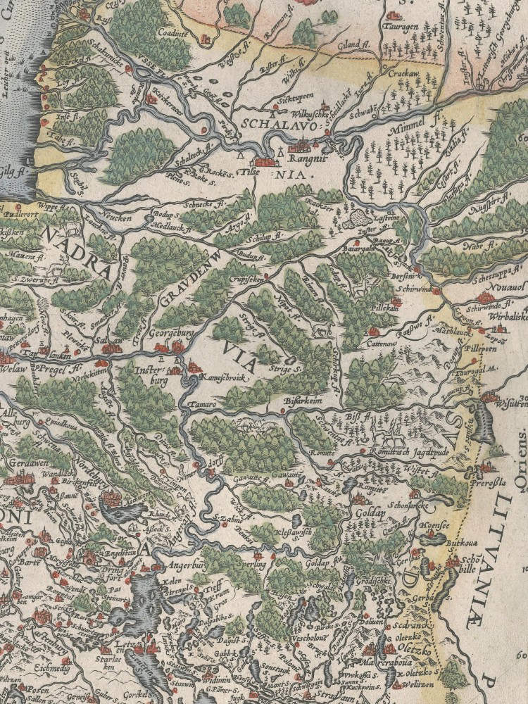
The wilderness of eastern Prussia
Caspar Henneberger noted that he devoted considerable effort to reconstructing the locations of the old districts and to identifying the rivers whose names he had read in the chronicles and related documents. He gave an example of the river that flowed through Mühlhausen, the town where Henneberger had lived for twenty-nine years. He wrote that no one in the town knew the river’s old name. The townsfolk called it the Mühlhausian River. Moreover, the river changed its name every few kilometres. In each town or village it flowed through, it took the name of that settlement.17
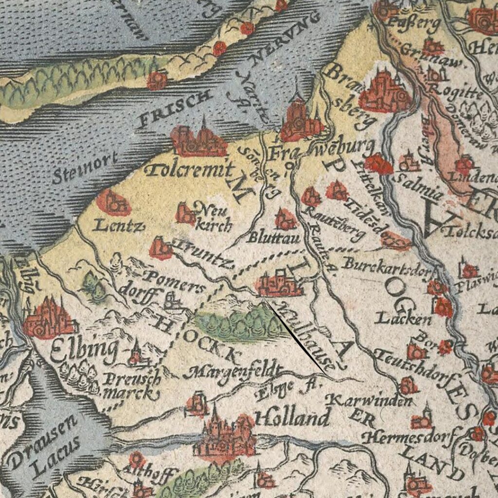
Mühlhausen on Henneberger’s Prussiae Map
The river was part of daily life in Mühlhausen and was integrated into the townsfolk’s spatial awareness of their area. But their perception of the river was localised around their town. People further up and down the river had their own daily spaces, regardless of what the river was called elsewhere or in some old chronicles. The same seemed to be true for many other rivers that Henneberger had to identify. I assume it was not just the minor rivers in Prussia that had shifting local identities, but that this was also the case in other rural or remote parts of Europe.
The various issues Caspar Henneberger encountered while working on the map stemmed from a discrepancy between the perception of local geography as people experience it daily and the descriptive approach of a map, which aims to standardise spatial knowledge. In the sixteenth century, as today, each person has their own take on the spatial properties of everyday life, shaped by daily routines, social networks and radius of activity. But thanks to modern education, we are familiar with the descriptive nature of maps for acquiring or communicating geographical knowledge. The names of rivers, mountains and landscapes are standardised and easy to look up.18 Mühlhausen is now called Młynary, and the river that flows through the town is the Bauda.
After these experiences, Henneberger, who had first written that he wanted to make a map showing all the blessings bestowed on Prussia, now remarked that he sometimes could not understand how the Lord could make such a difficult land.19 However, he persevered, and his map eventually gained widespread popularity, replacing the old map in all later editions of Theatrum Orbis Terrarum and in other atlases.
As an example of how a map could standardise geographic knowledge, Henneberger used the old names for the districts of Prussia, dating back to the time of the Teutonic Order and drawn from the names of the native Prussian tribes. What was, at the time of publication, an anachronistic use of outdated territorial names on a modern map became, thanks to the success and popularity of Henneberger’s map, copied and reused by other mapmakers for centuries, thereby keeping those names in circulation.20
Geography and Travel
The experiences of Caspar Henneberger show that in the sixteenth century, geographic knowledge was localised. Space was, in a way, a construct centred on an individual’s daily life and routines. For most people, the surroundings of their hometown marked the limits of their practical knowledge. This knowledge could be detailed and might include nearby towns and cities. But beyond the horizons of their daily experience, knowledge grew fuzzy and distorted. With uneven levels of general literacy and education, information about more distant neighbours was largely passed by word of mouth. The core sources were news and stories brought by travelling merchants, pedlars, carters, messengers and others whose daily life required them to travel longer distances. In addition, wealthier and better-educated people wrote letters or read books, cosmographies or the Civitates Orbis Terrarum. But these people were still a minority, as Caspar Henneberger’s difficulties showed.
How would a traveller like Samuel Kiechel find the way to a far-off destination in this conglomerate of local spaces? Maybe he asked for directions? But there was a difficulty with that. Imagine Samuel Kiechel leaving Rostock and asking for directions to Danzig. Many people might have heard of the city, but that did not mean they knew its direction or distance. So the obvious option would be for the traveller to ask for directions to places along the way, like Stralsund, Greifswald and Stettin. How did Samuel Kiechel know about the towns along the route to Danzig? All three places were larger towns and members of the Hanseatic League, so someone in Rostock could have told him about them. But asking for directions would be more difficult in less developed regions and would only work where our traveller spoke the local language.
A far more reliable method would be to have guides take travellers to their destinations. A fixture of Samuel Kiechel’s journey was his constant search for companions. Sometimes he spent days in a place until he found someone. As I mentioned multiple times before, travelling alone was dangerous, and there was safety in numbers to deter bandits and others who might take advantage of a lone traveller. But wayfinding was another key point, and finding a companion who spoke the local language was a bonus. Companions who knew the route were valuable. In particular, merchants, messengers and carters are repeatedly mentioned in the journal. All three professions required travelling and knowledge of the roads in their areas of activity.
Kiechel was not picky about his companions. He might grumble or complain about them, especially when it turned out that they did not know the way. But he also had little choice if he wanted to reach his destination.
How did Samuel Kiechel experience geographical space and keep track of his location? Most likely, from an egocentric point of view, in the linear fashion of a continuous route from one place to the next (like an itinerary). The distances that mattered to Kiechel were those he had to travel. This suggests that the dimensions of actual geographical space, i.e., the size of Europe and the extent of the lands he crossed, were most likely lost on him, or rather, outside the scope of his perception. For example, soon Kiechel would meet two English merchants, and they would travel together to Pskov in Russia. During his time there, Kiechel would casually mention that he had planned to travel to Moscow. But only when German merchants in Pskov told him how far it was and that there was nothing worthwhile to see along the way did he reconsider and decide against it. For us today, it is obvious that Moscow is quite some distance from the Baltic coast, and a quick look at a map would confirm it. But Samuel Kiechel did not have these options.
With these issues in mind, getting lost on a journey had a very different dimension than it does today. For Samuel Kiechel, it was not just a matter of ‘taking the wrong turn’. Kiechel described getting lost and spending hours trying to find his way. He might have quickly stumbled upon a road or path, but without road signs, how could he be sure it was the right one? And in which direction lay his destination? So, most likely, he would have to find someone who could point him to the next settlement.
In addition, rumours and certain stereotypes had greater influence on a traveller who was utterly dependent on local people to find his way. Kiechel repeatedly mentioned the danger of banditry and ambushes. Sometimes, this danger was real, as when he travelled through the Spanish Netherlands. At other times, it was more likely a common association of the time that dense forests were the home of outlaws.
As a result, Samuel Kiechel’s journey meandered through Europe and the eastern Mediterranean (see map). For a modern traveller, there would be more practical and efficient routes to connect all his major destinations, even if we discount modern means of transport. But the sixteenth century did not offer such tools. And even if a route could be planned, Kiechel’s experience shows it would soon be abandoned. He repeatedly wrote that he could not find companions to reach a specific destination and had to take a different route instead.
Other travellers of the time travelled with permanent companions, a teacher, a family member or a servant, and likely one of them had some experience with travelling and some knowledge about the world. But Kiechel went alone and chose companions along the way. This made his journey a constant stop-and-go whenever a temporary companion left him. It carried the danger of travelling with untrustworthy or even dangerous people, with supposed guides who did not know the way. But it also had benefits. Kiechel could change destinations on a whim when he heard about a worthwhile place, without needing a companion’s approval. He was also forced to step outside his comfort zone, even though this journey was already far beyond it. Needing guides to take him to his destination, Kiechel could not be choosy. Soon, he will travel with a Tatar to Vilnius and onward to Riga. The two men did not speak each other’s language, but Tatars worked as carters and the man knew the road.
But first, Samuel Kiechel would leave Danzig, travel to Königsberg (Kaliningrad), and then onwards through the wilderness of East Prussia to Grodno (Hrodna).
Illustrations & References
All images are in order of appearance with links to sources on external websites:
- Ortelius, Abraham (ed.), Theatre of the World, Antwerp 1587, fol. 87v; Library of Congress.
- Ortelius, Abraham (ed.). Theatrum Orbis Terrarum. Antwerp 1570, fol. 22v; Library of Congress.
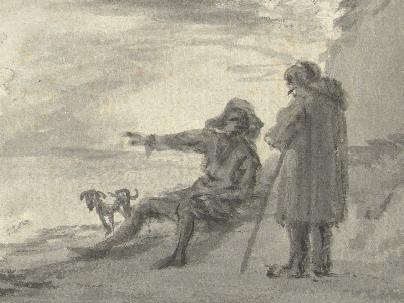
- Schellinks, Willem, Italiaans landschap, 1637 – 1678; Rijksmuseum Amsterdam.
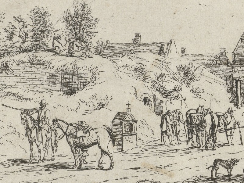
- van den Hoecke, Robert, Vele figuren op een pad bij een dorp, 1632 – 1679; Rijksmuseum Amsterdam.
- Cosgrove, Denis, Introduction: Mapping Meaning, in: Cosgrove, Denis (ed.), Mappings, London 1999, pp. 1–23, see p. 2. ↩︎
- Jäger, Eckhard, Prussia-Karten 1542–1810, Weißenhorn 1982, pp. 48-57. ↩︎
- Ibid., p. 48. ↩︎
- Henneberger, Caspar, Ercleru[n]g der Preüssischen grössern Landtaffel oder Mappen. Mit leicht erfindung aller Stedte, Schlösser, Flecken, Kirchdörffer, Orter, Ströme, Fliesser vnd See so darinnen begriffen, Königsberg 1595; Bayerische Staatsbibliothek. ↩︎
- Henneberger, Ercleru[n]g, p. 4; Jäger, Prussia-Karten, pp. 44-47. ↩︎
- Henneberger, Ercleru[n]g, Dedication. ↩︎
- Ibid., p. 11. ↩︎
- Ibid., p. 2. ↩︎
- Jäger, Prussia-Karten, pp. 48f. ↩︎
- Henneberger, Ercleru[n]g, p. 4. ↩︎
- Ibid., p. 6. ↩︎
- Ibid., pp. 5f. ↩︎
- Ibid., p. 3. ↩︎
- Jäger, Prussia-Karten, pp. 50f. ↩︎
- „wiltnisse der heren von Prusen“, in: Aussagen alter Leute über die Ausdehnung des D. Ordensgebietes an der Grenze Samaitens, in: Hirsch, Theodor, Toeppen, Max, Strehlke, Ernst (eds.), Scriptores Rerum Prussicarum – Die Geschichtsquellen der Preussischen Vorzeit bis zum Untergange der Ordensherrschaft, Vol. 2, Leipzig 1863, pp. 709–711. Joachim Erich (ed.), Marienburger Tresslerbuch der Jahre 1399–1409, Königsberg, Bremerhaven 1896 (reprint 1973), pp. 98, 115, 238, 408. ↩︎
- Striegler, Stefan, Raumwahrnehmung und Orientierung im südöstlichen Ostseeraum vom 10. bis 16. Jahrhundert. Von der kognitiven zur physischen Karte,
Stuttgart 2018, pp. 133-143. ↩︎ - Henneberger, Ercleru[n]g, pp. 6f. ↩︎
- Striegler, Raumwahrnehmung, pp. 220-236. ↩︎
- Henneberger, Ercleru[n]g, p. 4. ↩︎
- Striegler, Raumwahrnehmung, p. 230. ↩︎