Journal of Samuel Kiechel
29 – 31 July 1585
In Amsterdam
“Amsterdam is the capital of the Netherlands. It is a large, heavily fortified and densely populated city. Much trade occurs here due to the blockade of sea routes to Antwerp. Small ships can anchor in Amsterdam along an arm of the sea that extends deep into the city.“
Die Reisen des Samuel Kiechel aus drei Handschriften, K. D. Haszler (ed.), Stuttgart 1866, p. 16; Bayerische Staatsbibliothek.
A View of Amsterdam
Samuel Kiechel had sailed from Harlingen via Enkhuizen to Amsterdam. The voyage was uncomfortable due to strong winds, but he arrived in the Dutch capital on 29 July 1585. His ship entered the IJ, an arm of the Zuiderzee that served as Amsterdam’s only access to the North Sea. The IJ must have been busy with large and small vessels. Kiechel noted that canals extended deep into the city, allowing smaller boats to moor within Amsterdam. Larger ships with a deeper draught had to anchor further away, being loaded and unloaded by numerous smaller, lighter craft.

View of the harbour and the Haringpakkerstoren


Pieter Bast’s view of Amsterdam, 1599
The Dutch artist and engraver Pieter Bast created a profile view of Amsterdam and its busy harbour seen from the IJ. The foreground of the view is dominated by several large ships at anchor. Behind them, the sprawling city and its large harbour filled with smaller vessels are visible. Notably, the section of the harbour on the left resembles a forest of ship masts. In the centre, a wide canal runs deep into Amsterdam.
Claes Jansz. Visscher, an Amsterdam engraver and publisher, issued Bast’s view as part of a larger print in 1611, accompanied by a text and four images of notable sites in Amsterdam. These smaller images depict Dam Square, including the town hall and weighing house, the Stock Exchange, the meat market and the fish market.
Dam Square was the centre of the city. As its name suggests, it was once a dam across the Amstel River, which gives Amsterdam its name. The image shows a lively square, the Nieuwe Kerk, and two municipal buildings: the town hall and the weighing house.
Weighing houses existed in many cities. As the name indicates, their purpose was to weigh goods for trade and tax purposes. The units of weight used in early modern Europe varied from country to country. The weighing house stored scales for weighing large quantities of trade goods and, being a municipal building rather than a private enterprise, its measurements were reliable and legally recognised.

Dam Square

Stock Exchange
The Amsterdam Stock Exchange had not yet been established when Kiechel visited; it was founded in 1611. Initially, it served as a marketplace for goods and commodities. As Dutch trade expanded to Asia, the Dutch East India Company needed investors to finance its risky voyages; stocks in such voyages began to be sold at the Stock Exchange.
Regarding the meat and fish markets, as their names imply, they were venues for selling meat and fish. Due to the lack of refrigeration, both had to be sold quickly. The fish market was located beside a canal, facilitating easy access for fishing boats.

Amsterdam’s meat market

Fish market
Antwerp’s Decline and Amsterdam’s Rise
Drawings, paintings and engravings of Amsterdam and its harbour from the late sixteenth and seventeenth centuries exist in large numbers. Amsterdam was on the rise at that time. Until the 1570s, Antwerp had been the most significant economic centre in the Low Countries. However, in 1576, during the Eighty Years’ War, mutinous Spanish troops sacked Antwerp, resulting in a bloodbath among the inhabitants. For a time, this gruesome event united the still-loyal provinces of the Spanish Netherlands and the rebellious northern provinces in a common cause to drive out all marauding Spanish troops.
In July 1584, Spanish troops besieged Antwerp once more, blocking the river Scheldt. The Scheldt was the city’s access to the sea and, thus, to its trade routes. At the time of Samuel Kiechel’s visit to Amsterdam, Antwerp was still under siege but was set to surrender a few weeks later (17 August 1585). The economic changes resulting from the sack of Antwerp in 1576 and the current blockade were already being felt. Trade was redirected to Amsterdam, as the shallow Zuiderzee remained secure in Dutch hands.
Following Antwerp’s surrender, the Spanish pressured the city’s Protestant population to convert or migrate. Consequently, many Antwerp Protestants relocated to Amsterdam. The siege, particularly the loss of prosperous Dutch merchants and artisans, contributed to Antwerp’s economic decline towards the end of the sixteenth century. In its place, Amsterdam emerged as the new centre of trade. Samuel Kiechel would visit the captured city of Antwerp during his return journey from England in a few months.
The Beginning of the Dutch Golden Age

The late sixteenth century marked the early stages of the Dutch Golden Age. The northern provinces that had rebelled against Spanish rule had formed the Dutch Republic, which, in turn, evolved into a significant economic and cultural power in Europe. Trade formed the foundation of the Republic’s rise. As a coastal nation, its inhabitants possessed expertise in shipbuilding and the capability to mass-produce new vessels. Despite the ongoing conflict with Spain, the Dutch successfully built a robust navy and merchant fleet.
The foundation for the success of the Dutch merchant fleet was the development of better ship types, in particular the Fluyt. The Fluyt would dominate merchant shipping for many decades. It was designed purely as a cargo vessel and featured minimal or no armament. Consequently, the Fluyt was cheaper to produce, could carry more cargo, and required fewer crew members than similarly sized vessels of the time. Dutch merchants were thus able to outcompete their rivals.

A Fluyt
With the wealth acquired from European trade, the Dutch financed increasingly daring yet often profitable ventures by entering the spice trade. Since the Middle Ages, spices such as pepper, nutmeg, cinnamon and cloves have been luxury goods in Europe. They needed to be imported from Asia and were therefore expensive. Following the Portuguese discovery of the sea route around Africa, Western European merchants began playing an active role in Asian trade. Spices became cheaper due to direct access to the Indian Ocean. The old trade route from Asia overland to ports in the western Mediterranean and onwards by Venetian and Genoese ships was no longer profitable. In the sixteenth century, Portugal dominated the trade with Asia and supplied the European spice market.
Merchants from the rebellious Dutch provinces lost access to this market with the start of the Eighty Years’ War and the dynastic union of Spain and Portugal in 1580. However, due to the Iberian Union, Portuguese overseas possessions became legitimate targets for Dutch incursions. Dutch merchants financed the first expedition of four ships to the East Indies in 1595. Once it successfully returned, more expeditions were launched. Initially, shareholders established a company to finance a single expedition and dissolved it shortly after its return.

The Return to Amsterdam of the Second Expedition to the East Indies, 19 July 1599
Due to the high risks involved in such ventures, fluctuations in spice trade prices and the need to organise and control various expeditions, the Vereenigde Oostindische Compagnie (United East India Company) was founded in 1602. Through the East India Company’s organisational capabilities, the Dutch monopolised the trade of certain spices in Europe.
The influx of wealth from European trade and expeditions to the East Indies raised the standard of living in the Dutch Republic. This development, in turn, influenced Dutch art and culture of the period, leading to an increased demand for cultural commodities. The art market flourished, with Dutch artists developing new techniques and establishing new genres.

View across the roofs of Amsterdam towards the Ij
Dutch art of the seventeenth century is renowned for masters like Johannes Vermeer and Rembrandt van Rijn. Their paintings reflect the pinnacle of a period marked by political stability, economic prosperity and cultural advancement. The various drawings, paintings, and prints by Dutch artists from this period are an excellent source for illustrating Samuel Kiechel’s journey. The works of many Dutch artists offer a glimpse into the worlds encountered by Kiechel, much like the Civitates Orbis Terrarum depicts how cities looked to our traveller.
A large number of prints, drawings and paintings produced and published in the late sixteenth- and seventeenth-century Netherlands can be viewed in the digital collection of the Rijksmuseum in Amsterdam.
The Expanding City
Samuel Kiechel spent only one day in Amsterdam, and his description is brief. He wrote: Amsterdam is the capital of the province of Holland. It is large, well-populated and fortified. The city is an important trade centre because all sea traffic to Antwerp is blocked.

Amsterdam’s Noordermarkt and Noorderkerk
Two bird’s-eye views of Amsterdam appear in the Civitates Orbis Terrarum. Both views show the city from the northeast with the IJ in the foreground. The first view depicts Amsterdam as a sprawling place surrounded by a strong wall. A broad canal or moat encircles the city, and another wide canal runs through its centre. Numerous smaller boats occupy this canal, while various smaller waterways traverse the city. Amsterdam’s commercial success is emphasised by the many large ships at anchor.

Bird’s-eye view of Amsterdam, 1572
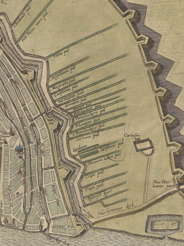
The second bird’s-eye view of Amsterdam is somewhat unusual. Most images in the Civitates illustrate the buildings of a city, usually highlighting relevant structures with attention to detail. However, this second map of Amsterdam prioritises the streets and canals. In this respect, the image is somewhat similar to Jacob van Deventer’s work. No other buildings except churches and a few municipal structures are visible, and the names of the streets and some canals are inscribed on the map. Additionally, new canals and fortifications are drawn outside the perimeter of the old walls, giving this view the appearance of a construction plan.

Bird’s-eye view of Amsterdam, 1627
The first view of Amsterdam, published in 1572, was a reproduction of an older image from 1538 by Cornelis Antonisz. The second view of Amsterdam was published in 1618 and shows the changes that occurred over the intervening eighty years.
Since 1538, Amsterdam had grown considerably due to the arrival of Protestant refugees from Antwerp and increased trade and commerce. The city’s old fortifications could no longer accommodate the increasing number of houses.
In 1612, construction began to expand the city. Notably, three new canals were created: the Herengracht, Keizersgracht and Prinsengracht. These would run in parallel, forming a semicircle around the city. The construction would take several decades and be completed in the 1660s.
Planned expansion of Amsterdam
The second view of Amsterdam from 1618 shows the early stages of this expansion. The Herengracht is the canal closest to the city centre, and its route follows the old moat depicted in the first view. On the right side, a new ring of fortifications is visible. The moat alongside the new fortifications is today’s Singelgracht, which marked the city’s new boundary following its first expansion. The construction of the Keizersgracht and Prinsengracht was not yet planned.
Departure
Samuel Kiechel left Amsterdam on the afternoon of 31 July. He went to a gate in search of transport. As previously mentioned, carts would regularly wait at the city gates to pick up passengers. Alongside three other passengers, Kiechel rode on a cart to Haarlem, three miles west of Amsterdam. The gate of Amsterdam leading onto the road to Haarlem is the first gate on the right in the bird’s-eye view, labelled “Haerlemmer poort” on the 1618 map.

The gate and the road to Haarlem
Illustrations & References
All images are in order of appearance with links to sources on external websites:
- Nooms, Reinier, Noordermarkt met de Noorderkerk, 1657-1662; Rijksmuseum Amsterdam.
- Nooms, Reinier, Haringpakkerstoren, 1652-1654; Rijksmuseum Amsterdam.
- Bast, Pieter, Amstelredam, 1599; Rijksmuseum Amsterdam.
- Visscher, Claes Jansz., View of Amsterdam, 1611; Rijksmuseum Amsterdam.
- de Verwer, Abraham, View of Hoorn, 1650; National Gallery of Art, Washington.
- Hollar, Wenceslaus, Naues Mercantoriæ Hollandicæ, vulgo, VLIET, 1647; Metropolitan Museum of Art, New York.
- Vroom, Hendrik Cornelisz, The Return to Amsterdam of the Second Expedition to the East Indies, 1599; Rijksmuseum Amsterdam.
- van Ruisdael, Jacob Isaacksz, Panoramic View of Amsterdam, Looking towards the IJ, c. 1665; Rijksmuseum Amsterdam.
- Amsterdam, in: Braun, Georg, Hogenberg, Fran, Civitates Orbis Terrarum (1), Cologne 1593, fol. 20v; Heidelberg University.
- Amsterdam, in: Braun, Georg, Hogenberg, Frans, Civitates Orbis Terrarum (6), Cologne 1618, fol. 10v; Heidelberg University.