
Journal of Samuel Kiechel
3 September – 4 October 1586
From Reval to Danzig
“On the afternoon of the 11th, we spotted land; we were close to Königsberg. The owner of the salt [the ship’s cargo] wanted the helmsman to sail there. Meanwhile, night was approaching, and the wind picked up. The helmsman did not dare approach the coast in darkness. The entrance [to Königsberg] was called Nehrung, and it was dangerous. The helmsman said he had not entered it in 14 years. They began to argue as the wind increased and turned into a storm.”
Die Reisen des Samuel Kiechel aus drei Handschriften, K. D. Haszler (ed.), Stuttgart 1866, p. 133; Bayerische Staatsbibliothek.
Departing Reval (Tallinn)
Samuel Kiechel left Livonia on 3 September 1586, aboard a ship bound for Danzig (Gdańsk). The ship was Dutch, and its owner was from Enkhuizen. The vessel was loaded with salt. The recipient of the salt in Reval refused to pay the agreed price, so the ship’s owner decided to sail to Danzig and try to sell the salt there.
According to Kiechel, the ship carried forty-two ‘Last’ of salt. ‘Last’ was a common unit of weight and volume used to estimate a ship’s carrying capacity. One ‘Last’ weighed about 2,000 kilograms or about 2.7 cubic metres.
Danzig was one hundred miles closer to the Netherlands than Reval, Kiechel wrote, and the price of salt would be three Reichsthaler per ‘Last’ lower than in Livonia. Given the journey’s duration so far and the expenses of the detour, the ship’s owner would struggle to make any profit.
When Kiechel’s ship was away from the harbour and out at sea, the wind strengthened. It came from the northeast, which was very beneficial for them, and by the following evening they had already sailed into the Bay of Riga. Kiechel wrote that the bay was a dangerous place in stormy weather.1
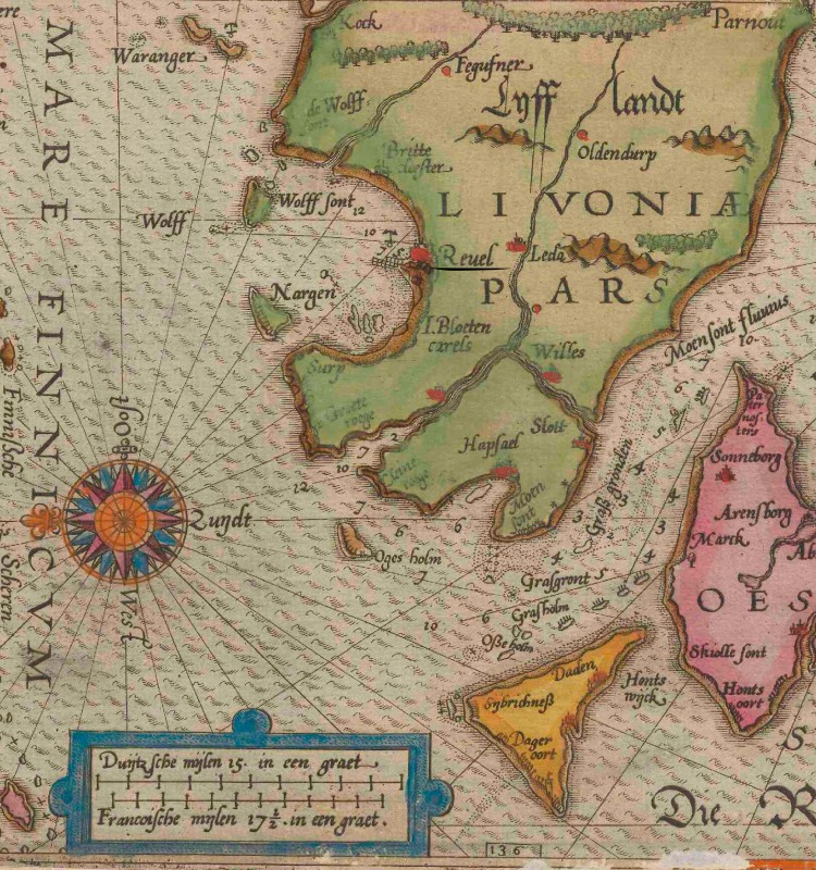
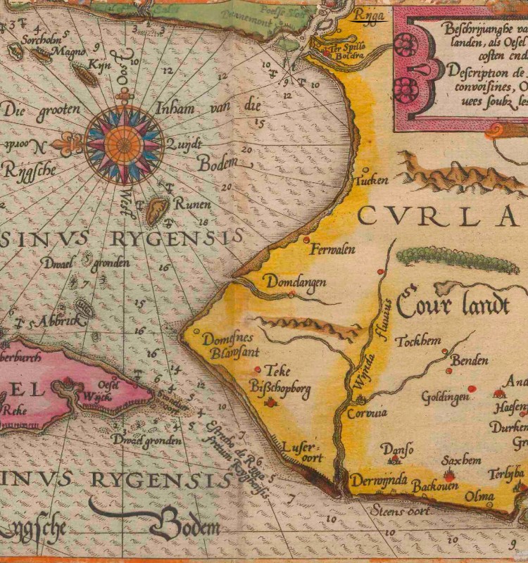
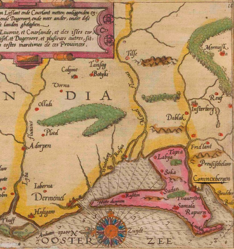
Naval chart of the Baltic Sea coast from Reval (Reuel) to Königsberg (Conincxbergen) with the Bay of Riga (Sinvs Rygensis), 1596
Maritime Trade in the Baltic Sea Region
Trade in the Baltic Sea region was profitable yet volatile. For centuries, the Hanseatic League sought to monopolise it and, for merchants with access, to establish legal frameworks and a network of friendly ports and trading posts to make trade predictable and profits secure. But storms, ship losses, war, disease and political turmoil always posed risks.
In the Middle Ages, merchants sailed from port to port to buy and sell goods. The risks of these endeavours were high, and the loss of ships, cargo and lives was ever-present. To spread risk and reduce costs, merchants stopped financing their own ships and instead paid for transport. Within the Hanseatic League’s network of large Kontors (offices in London, Bruges, Bergen and Novgorod) and small trading posts in other cities, merchants soon stopped accompanying their goods. Instead, they maintained a permanent presence, a subordinate merchant or servant, in the cities they traded with.
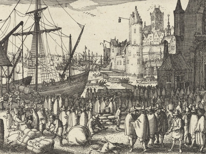
The ships used for transport in the Baltic trade were either owned by an individual or, more often, by multiple people to spread the cost. Often, the ship’s owner or his subordinate, along with the crew, handled transport and delivery but no longer had a stake in the cargo. Amid the dangers of medieval and early modern seafaring, what had once been a common undertaking, with everyone on board having an interest in safe delivery, became for the involved sailors a job with fixed, often low, pay.
As the League declined, other parties gained access to the Baltic Sea market. First and foremost among the new merchant powers in the Baltic were the Dutch. Grain and salt were bulk goods, and modern Dutch ships, developed in the sixteenth century, could carry more cargo at lower cost. Samuel Kiechel noted the large number of merchant ships entering and leaving the Baltic Sea when he was in Helsingør on the Øresund.
The Baltic trade, particularly the grain trade, formed the core of the Dutch economy. Beyond the lucrative trade itself, grain from the Baltic Sea region fed the Netherlands’ growing population. The Dutch imported grain, tar, timber, hemp, flax and other raw materials from western Europe and exported salt, wine, herring, textiles and manufactured goods to the east. Although they did not trade in exotic, highly prized commodities, these routes were the backbone of the Dutch Republic’s economy, known as the ‘mother trade’. Using its profits and a system of investors or shareholders, Dutch merchants funded expeditions to Asia, laying the foundations of the Dutch colonial empire in the seventeenth century.
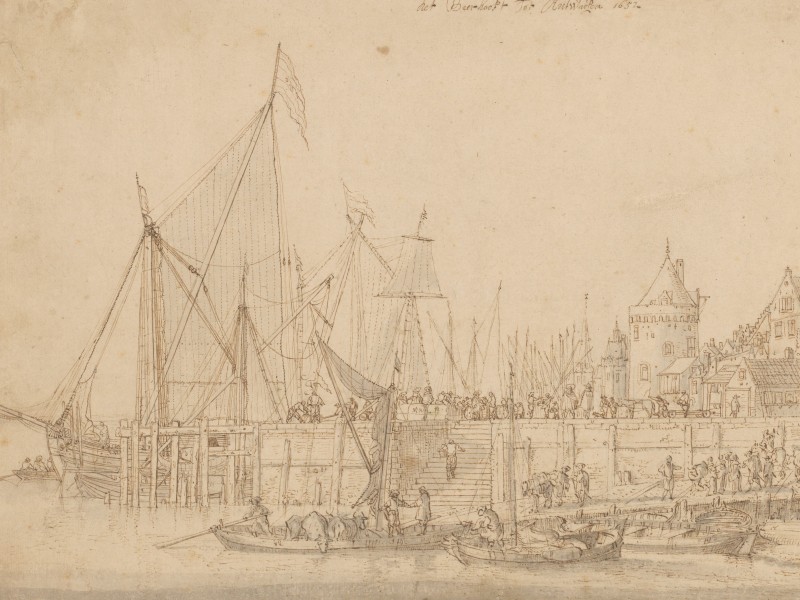
In Kiechel’s case, the ship’s owner also appears to have been the merchant who tried to sell the salt. Salt was an important and lucrative trade commodity in the early modern period. It was one of the few ways to preserve food. Initially, most of the salt traded in the Baltic Sea region came from Lüneburg in northern Germany. Kiechel had visited the city and seen the saltworks. But in the fifteenth and sixteenth centuries, French sea salt from the Atlantic coast became a popular alternative because it was cheaper.
Samuel Kiechel wrote that the recipient of the salt in Reval refused to accept it. He might have gone bankrupt or at least no longer had the money to pay for it. Alternatively, he may have been unhappy with the salt’s quality. The risk fell to the ship’s owner, who had just sailed all the way to Reval for nothing. Every further day at sea cut into his profits, and now he was doubling back along the coast. The closer he got to Lüneburg, the lower the price would be.
Königsberg or Danzig?
At midnight on 4 September, the wind turned. The ship carrying our traveller had to sail into the wind for several days. At noon on 11 September, they spotted land and arrived off Königsberg.
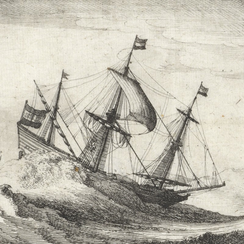
The ship’s owner decided to stop in the city. But the wind remained strong throughout the afternoon and night, and the helmsman did not dare approach the coast. According to Kiechel, the entrance to Königsberg was called the Nehrung, a very dangerous place to sail through. The ship’s owner and the helmsman began to argue. The helmsman said he had not sailed to Königsberg in fourteen years and was therefore no longer familiar with the area. Meanwhile, the wind increased and turned into a storm. It settled the argument, as they could neither stay there nor enter the harbour. The ship had to turn away from the coast, and the storm pushed it westward.
The following morning, they were already close to Danzig. But the wind was so strong that a sail tore apart, and the ship began to lean heavily to one side. Kiechel wished he were back on land. He wanted to be off the ship. He wrote he had not eaten or drunk much in the last four days. He had enough provisions, but felt too unwell to eat or drink because of the sea’s movement. Kiechel calmed himself with the knowledge that the Dutch, like the English, were the best sailors and could handle such weather better than others.
Throughout the day, the ship remained at sea, in sight of the mouth of the Vistula River, which led to the harbour of Danzig. The ship’s owner still wanted to sail to Königsberg, hoping to sell his cargo of salt there. Unfortunately, the sea was too rough to bring Kiechel ashore by boat. Our traveller had to stay on board all day, watching about thirty Dutch ships enter the harbour. Kiechel felt bored and helpless. He mused that if the wind turned, the ship’s owner would have sailed back to Königsberg. And Kiechel would have been forced to come along.
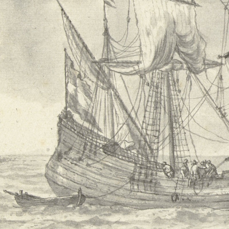
Fortunately, the wind did not shift and calmed in the evening. Our traveller was brought ashore, where he hired a boat to take him upriver to Danzig.2
Navigating the Baltic Coast
Maritime trade was central to the Baltic Sea region. Many ships sailed from west to east each year. Yet despite the high volume of traffic, each ship’s safe passage depended on many factors. One crucial factor was the helmsman’s and crew’s experience. In the sixteenth century, sailors navigated the Baltic Sea largely by following sailing instructions, using coastal landmarks and measuring depth to avoid running aground. The new instruments used by the Portuguese, Spanish and other seafaring nations were not really necessary in the comparatively narrow confines of the Baltic. In contrast to Atlantic voyages, or even the Mediterranean, a ship sailing the Baltic Sea was never far from the coast.
Naval charts were a relatively late introduction to the region. To accommodate the prevalent use of landmarks, many charts included drawings of coastal profiles. I have previously mentioned Lucas Jansz. Waghenaer and his two collections of naval charts, the “Spieghel der zeevaerdt” (1584) and “Thresoor der zeevaert” (1592).3 The following map from the “Spieghel der zeevaerdt” shows the coast between Königsberg (Kaliningrad) and Danzig (Gdańsk).
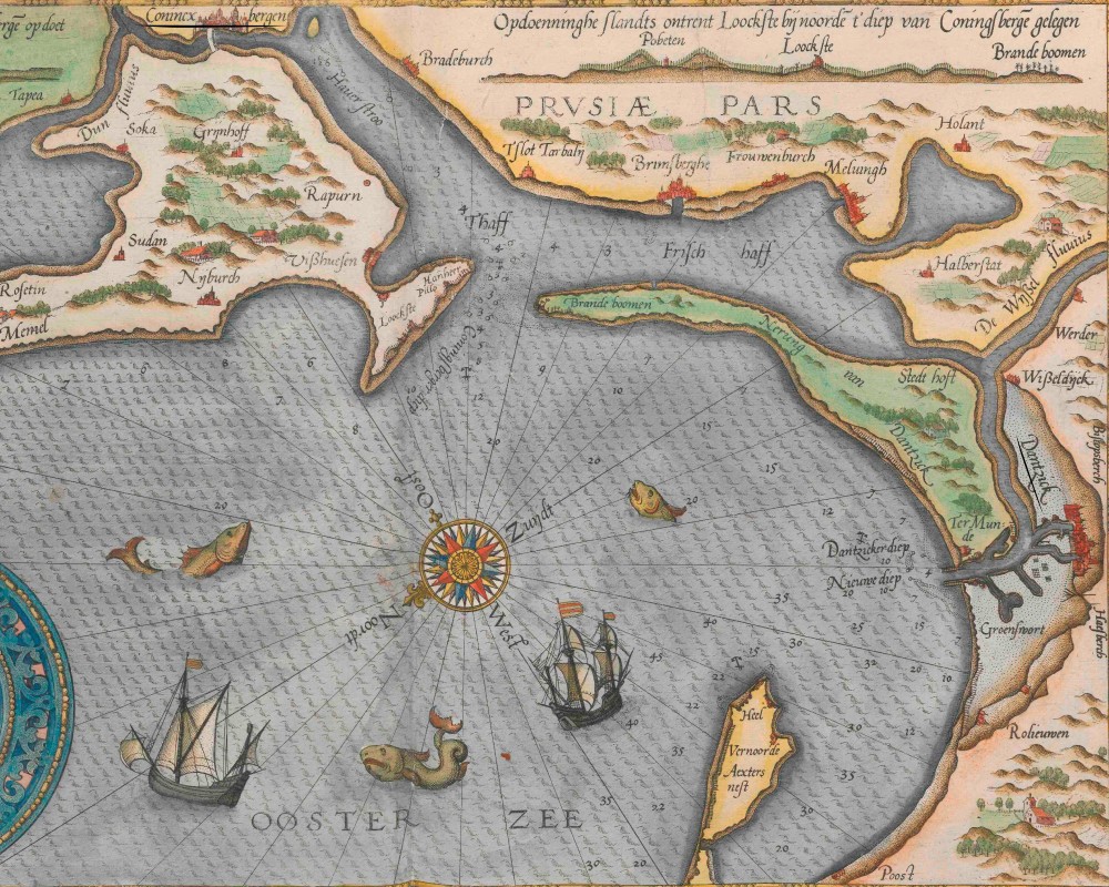
Naval chart of the Baltic Sea coast from Königsberg (Conincxbergen) to Danzig (Dantzik), 1585
Samuel Kiechel wrote that the entrance to Königsberg was called the Nehrung. A ‘Nehrung’ is a long, narrow sandbar that separates a lagoon from the sea. Two ‘Nehrungen’ lie on the eastern coast of the Baltic Sea: the Curonian Spit, which separates the Curonian Lagoon from the sea north of the large Sambia peninsula, and, south of it, the Vistula Spit, which forms a barrier to the Vistula Lagoon. Both lagoons could be entered via a narrow strait.
The owner of Kiechel’s ship wanted to sail into the Vistula Lagoon because, at its northern end, the Pregel River (Pregolya) led to the harbour of Königsberg. The map shows the narrow entrance and includes information on water depth. In the upper-left corner is a coastal profile of the area, and the Dutch text above it reads: The rising sands (or rising coastline) near Loockste, situated north of the Königsberg Diep. The Königsberg Diep is the strait into the Vistula Lagoon (Strait of Baltiysk). In German, it is called Pillauer Tief after the town of Pillau (Baltijsk) on its northern shore (Pillo on the map).
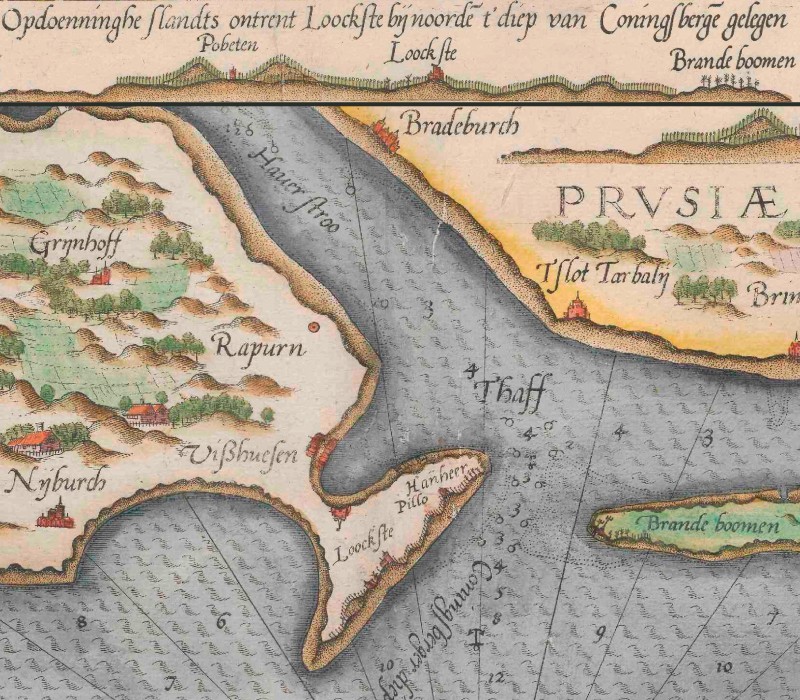
The Königsberg Diep on the chart with the coastal profile inserted above
Loockste, in the coastal profile and on the map, was Lochstedt Castle. The Teutonic Order founded the castle in the thirteenth century during its conquest of Prussia. However, once the better-located Königsberg was founded in 1255, Lochstedt had no meaningful function and fell into decay. It nevertheless survived until after the Second World War, and its remains were demolished in the 1960s. In the early modern period, it seemingly served as a landmark for ships entering the Vistula Lagoon. On the other side of the Königsberg Diep, some burnt trees (“brande boomen”) served as a landmark.
The strait is not actually visible in the profile because the opposite coastline of the Lagoon was too close. To give sailors another landmark to establish their position, a place called “Pobeten” appears on the left side of the profile. However, the map shows no such location nearby. Pobethen (Romanowo, Oblast Kaliningrad) was not on the coast but about thirty-five kilometres inland, north-east of the strait. It was actually closer to the north coast of Sambia. However, Pobethen had a church from the fourteenth century that was considered the largest village church in Sambia. Its tower could be seen from far away. Apparently, from a position close to the Königsberg Diep, the Pobethen church tower was visible between two low hills. With some knowledge of the area and the use of lead and line, an experienced helmsman could use this position to approach the strait and sail into the Lagoon.
Nevertheless, as Kiechel mentioned, the Königsberg Diep remained dangerous to navigate, and the ship’s helmsman did not feel confident enough to proceed. According to Samuel, the helmsman said he was no longer familiar with the area. This familiarity included knowledge of landmarks, currents, depths and local underwater hazards, which was the most important part of navigation, despite the naval charts. The weather eventually became the deciding factor, with the wind pushing the ship away from the coast.
Arriving near Danzig, the situation was not much different. Access to the harbour was via the mouth of the Vistula River. Again, the map shows a narrow entrance, shallow water and sandbanks. But there is no coastal profile for this part of the coast. This was unnecessary because a lighthouse marked the entrance for ships. Kiechel had seen it on his first visit to Danzig.
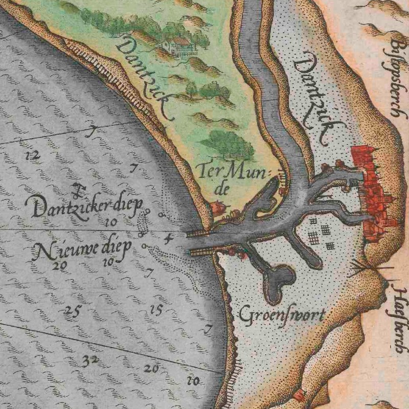
The mouth of the Vistula River on the coastal chart, 1585
The helmsman of the ship was again reluctant to approach the coast in the stormy weather. But Kiechel wrote that he watched about thirty ships enter the harbour. This might again be a question of experience. The ship carrying our traveller had sailed to Reval, and the journey to Danzig was not planned. For direct trips to Reval from the western Baltic Sea, ships could sail along the Swedish coast to Gotland and then cut across to Livonia. Maybe the helmsman was used to this northern route and was indeed unfamiliar with the south-eastern coastline. In contrast, the other Dutch ships sailing to Danzig came to pick up grain for western Europe. This was such a regular and profitable route that the crew on those ships must have been familiar enough with the area to enter the Vistula even in bad weather.
In Danzig Again
Samuel Kiechel stayed in Danzig (Gdańsk) for three weeks. He was not particularly happy about it. He had already visited the city, but his new companion, a Dutchman, delayed his departure. This Dutchman had married a woman from Danzig and had a house in the city. He postponed their departure day after day. Despite these early annoyances, Kiechel wrote that this companion would stay with him until Ancona in Italy.
Kiechel presumably spent the time waiting as best he could. He wrote nothing about his second visit to Danzig apart from an execution he witnessed in the city’s suburb of Schottland. Under torture, the condemned had confessed to arson. He had set fire to the house of a citizen in the town of Wollenberg (?). The fire had spread, and around one hundred houses burnt down. The criminal was executed by burning at the stake. He survived the fire for a long time before he suffocated. Kiechel added that Schottland had judicial autonomy, and Danzig had no influence over how justice was administered.
Eventually, the Dutchman was ready to leave. They bought provisions, hired a coach to Posen (Poznań), and left on the afternoon of 4 October.4
Illustrations & References
All images are in order of appearance with links to sources on external websites:
- Waghenaer, Lucas Jansz, Thresoor der zeevaert, 1596, fol. 142v; Utrecht University Repository.
- Ibid., fol. 136v; Utrecht University Repository.
- Visscher, Claes Jansz., Handel en koopvaardij, 1608; Rijksmuseum Amsterdam.
- Peeters, Bonaventura, Het Bierhooft tot Antwerpen, 1652; Rijksmuseum Amsterdam.
- Hollar, Wenceslaus, Zeilschepen in een zeestorm, 1627 – 1636; Rijksmuseum Amsterdam.
- Nooms, Reinier, Zeegezicht met twee driemasters en een beurtvaarder, 1633 – 1667; Rijksmuseum Amsterdam.
- Waghenaer, Lucas Jansz, Tweede deel vande Spieghel der zeevaerdt, 1585, fol. 15v; Utrecht University.
- Die Reisen des Samuel Kiechel aus drei Handschriften, K. D. Haszler (ed.), Stuttgart 1866, p. 132; Bayerische Staatsbibliothek. ↩︎
- Ibid., pp. 132-134. ↩︎
- Waghenaer, Lucas Jansz., Teerste [-tweede] deel vande Spieghel der zeevaerdt, vande navigatie der Westersche Zee, innehoudende alle de custen van Vranckrijck, Spaignen ende ‘t principaelste deel van Engelandt, in diversche zee caerten begrepen, Leiden 1585; Utrecht University Repository; Waghenaer, Lucas Jansz., Thresoor der zeevaert, inhoudende de geheele navigatie ende schip-vaert vande Oostersche, Noordtsche, Westersche ende Middellantsche Zee, met alle zee-caerten daer toe dienende …, Amsterdam 1596; Utrecht University Repository. ↩︎
- Reisen des Samuel Kiechel, p. 134. ↩︎